Overall Altitude Overview of Duku Highway
The charm of Duku Highway lies essentially in the “magic of altitude”. Built along the veins of the Tianshan Mountains, it deliberately passes through geographical units of different altitudes, allowing travelers to experience a complete landscape zone from temperate grasslands to alpine periglacial regions within hours. Understanding its overall altitude distribution is the first step in planning your trip.
Core Law of Altitude Change: Three-Stage Distribution of “Low in the North, High in the Middle, Then Sharp Drop”
Divided by Bayanbulak Grassland, Duku Highway can be split into northern, middle, and southern sections, with an obvious stepped altitude change. Each section corresponds to distinctly different scenery:
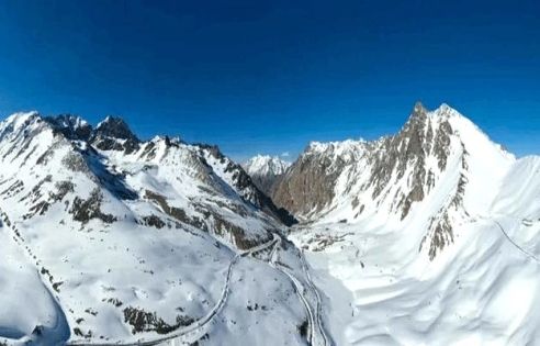
- Northern Section (Dushanzi → Nalati): Rapid Altitude Climb SectionStarting from Dushanzi at approximately 650 meters, it ascends along the northern foot of the Tianshan Mountains. By Qiaerma, the altitude rises to 2,000 meters, and upon reaching Nalati Grassland, it is around 1,800 meters. The most thrilling part of this section is “Hasihugen Daban”, where the altitude surges to 3,400 meters—the highest point of the entire route. It is a classic section to experience the leap from “oasis to snow-capped mountains”.
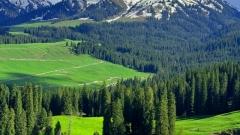
- Middle Section (Nalati → Bayanbulak): Stable High-Altitude Platform SectionTraveling southeast from Nalati Grassland, the altitude remains between 1,800-2,500 meters. With an open terrain, the entire section passes through the core area of Bayanbulak Grassland, making it the best route to admire the “horizon grassland”. There are almost no drastic altitude changes, so the body can easily adapt.
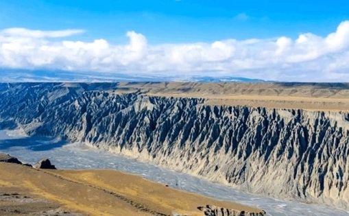
- Southern Section (Bayanbulak → Kuqa): Sharp Altitude Drop SectionStarting from 2,500 meters in Bayanbulak, it travels south along the southern foot of the Tianshan Mountains. After passing the Big and Small Dragon Pools, the altitude gradually decreases. Entering the Kuqa Canyon area, it drops to 1,200 meters, and upon reaching the endpoint Kuqa City, the altitude is only 1,070 meters. The scenery quickly transitions from grasslands to gobi and red mountain canyons.
Altitude Overview of Key Nodes: Don’t Miss These Landmarks
The altitude markers of several core nodes along the route are not only geographical coordinates but also signals for scenery transitions. Overseas travelers can confirm the altitude via on-board navigation or roadside signs and prepare in advance for the experience:
| Core Nodes | Altitude (meters) | Scenic Features & Precautions |
| Dushanzi (Start) | 650 | Gobi starting point, dry climate, no risk of altitude sickness |
| Qiaerma Martyrs Memorial | 2,000 | Junction of grassland and forest, can stop to adjust and adapt to the initial altitude increase |
| Hasihugen Daban | 3,400 | Highest point of the entire route, permanent residual snow year-round, high-risk area for altitude sickness, recommended stay ≤ 30 minutes |
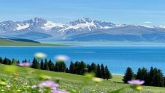
| Nalati Grassland | 1,800 | “Alpine Grassland”, comfortable altitude, ideal for adjustment after high-altitude travel |
| Bayanbulak Grassland | 2,500 | Plateau wetland grassland, note the low night temperature, mild altitude sickness may occur |
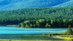
| Big and Small Dragon Pools | 2,300 | Alpine lakes, stable altitude, suitable for photo stops |
| Kuqa Tianshan Grand Canyon | 1,200 | Low-altitude gobi canyon, hot and dry, can relieve high-altitude discomfort |
| Kuqa (End) | 1,070 | Southern Xinjiang basin climate, warm and comfortable, end of high-altitude experience |
Seasonal Wonders Created by Altitude: Scenic Experiences at Different Heights
The secret behind Duku Highway’s “four seasons in one day” lies in the climatic differences caused by altitude. Even during the opening period (June-October), the scenery at different altitude sections may vary drastically at the same time—this is precisely its most attractive highlight for overseas travelers.
Above 3,000 Meters: A “Winter Wonderland” with Permanent Snow Line
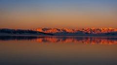
The high-altitude area above 3,000 meters, centered on Hasihugen Daban, is on the edge of Tianshan’s “permanent snow line”. Even in the midsummer of July-August, there may be meters of snow piled beside the road, and the temperature can drop below 5℃ when mountain winds blow, just like winter. The scenery here mainly consists of bare rocks, glaciers, and snowfields. Looking far away, you can see the snow-capped peaks of the Tianshan main range; nearby, there are cold-resistant alpine meadows, and occasionally, herdsmen’s yaks can be seen foraging near the snow.
For overseas travelers experiencing this area: Even if it’s hot inside the car, put on warm coats, hats, and gloves before getting off to avoid colds caused by sudden temperature drops; snow reflection is strong, so it’s recommended to wear sunglasses to prevent snow blindness. This is a highly impactful photo spot—you can take contrasting photos of “standing in front of snow in short sleeves”, which will become a classic travel memory.
2,000-3,000 Meters: A Cool Spring & Autumn Paradise
This altitude range covers core attractions such as Qiaerma and Bayanbulak Grassland, belonging to a temperate plateau climate. The average summer temperature is between 15-20℃, cool and comfortable, making it an ideal place to escape the heat. In June, this area is an “emissary of spring”—wild lilies and globeflowers bloom one after another on the grassland, and streams converge from snowmelt, gurgling through the lush green land; in September, it enters a “autumn painting”—poplar leaves turn yellow, birch leaves redden, interweaving with green grasslands into a colorful tapestry.
Bayanbulak Grassland is representative of this altitude section. At 2,500 meters, the air is fresher and the night sky is clearer. You can photograph the bright Milky Way at night, making it a treasure for astronomy enthusiasts. The herdsmen here are mainly Mongolian; travelers can experience special foods such as mare’s milk wine and hand-grasped meat, and feel the plateau nomadic culture.
Below 2,000 Meters: A Passionate Summer Paradise
Low-altitude areas such as Dushanzi (650 meters) and Kuqa (1,070 meters) have a temperate continental climate. The summer temperature can exceed 30℃, presenting a strong “summer vibe”. Near Dushanzi in the northern section, at the junction of gobi and oasis, you can see camels walking on the gobi; in the Kuqa Canyon area in the southern section, there are red rock canyons, which glow with fiery halos under the sun, like a miniature version of the Flaming Mountain.
The scenery in low-altitude areas is full of passion and vitality. From June to July, farmland near Dushanzi is abundant with grapes, watermelons, and other fruits—you can taste fresh Xinjiang fruits; in Kuqa, there are traditional Uyghur villages where you can enjoy traditional music such as the Twelve Muqam and experience the unique customs of southern Xinjiang.
Must-Know for Overseas Travelers: High-Altitude Travel Safety & Health Guide
Faced with the maximum 3,000-meter altitude difference of Duku Highway, overseas travelers are most concerned about the prevention and response to altitude sickness. In fact, as long as you are fully prepared, most people can smoothly adapt to the altitude changes and enjoy the trip with peace of mind.
Prevention First for Altitude Sickness: Advance Preparation is Key
The occurrence of altitude sickness is related to personal physical condition and the speed of altitude increase. The core of prevention lies in “slow adaptation and enhanced physical fitness”. Overseas travelers can prepare in the following aspects:
- Pre-Trip Preparation: 1-2 weeks before departure, ensure adequate sleep, avoid staying up late and overworking; if you have underlying diseases such as hypertension or heart disease, it is recommended to consult a doctor in advance to confirm whether you are suitable for traveling to high-altitude areas; you can take Rhodiola rosea (a traditional Chinese medicine for preventing altitude sickness) 3 days in advance to help the body adapt to the hypoxic environment.
- Altitude Adaptation Rhythm: After arriving in Urumqi (800 meters), it is recommended to stay for 1 day before traveling to Duku Highway to avoid directly entering high altitudes from low altitudes; when driving to areas above 3,000 meters such as Hasihugen Daban, do not rush to run or jump after getting off the car. Walk slowly and give your body 5-10 minutes to adapt.
- Dietary Adjustments: Drink plenty of warm water during the trip, maintaining a daily water intake of over 2,000ml to promote metabolism; avoid heavy drinking, smoking, and excessive consumption of greasy and spicy food to reduce physical burden; appropriately consume local butter tea and dairy products, which help adapt to high altitudes.
Recognition & Response to Altitude Sickness: Learn to Handle Emergencies
Mild altitude sickness is a normal phenomenon—overseas travelers need not panic excessively, but they must learn to recognize the symptoms and handle them in a timely manner to avoid deterioration.
- Mild Altitude Sickness Symptoms: Dizziness, headache, fatigue, insomnia, loss of appetite, slightly rapid breathing. Usually occurs 1-2 hours after arriving at high altitudes and will relieve on its own within 1-2 days.
- Response Methods: Immediately stop strenuous activities, return to the car or a nearby rest point to sit quietly; drink plenty of warm water and take glucose oral solution to supplement energy; if the headache is obvious, you can take painkillers such as ibuprofen; ensure adequate sleep and avoid staying up late.
- Emergency Medical Attention Required: If severe symptoms such as severe headache, uncontrollable vomiting, difficulty breathing, chest tightness, or confusion occur, it may be a precursor to high-altitude pulmonary edema or cerebral edema. Immediately go to a low-altitude area and contact medical rescue.
Essential High-Altitude Item List: Don’t Miss Anything from Clothing to Medicine
Bringing appropriate items according to altitude changes is key to improving travel comfort. Overseas travelers can refer to the following list for preparation:
- Clothing: Layered dressing is essential—inner layer: breathable and quick-drying clothes; middle layer: thin down jacket or fleece; outer layer: windproof and waterproof jacket; pants: wear durable outdoor pants, which can be paired with thermal underwear; hats, gloves, and scarves are a must to resist high-altitude cold winds; shoes: wear non-slip outdoor shoes to avoid slipping on snow sections.
- Medicines: Altitude sickness prevention drugs (Rhodiola rosea, Gaoyuan’an); altitude sickness treatment drugs (glucose oral solution, ibuprofen); daily medicines (cold medicine, gastrointestinal medicine, band-aids); if you have chronic diseases, carry sufficient prescription drugs.
- Other Items: Sunscreen (SPF50+), lip balm with SPF, sunglasses (to resist snow reflection); insulated water bottle (drink warm water at all times); portable oxygen tank (available at pharmacies in Urumqi or Dushanzi, for backup); mobile power bank (ensure smooth emergency communication).
Itinerary Planning Combined with Altitude: Make High-Altitude Experiences More Comfortable
Reasonable itinerary planning that conforms to altitude change rules can minimize the impact of altitude sickness and enhance travel experience. Below are two altitude-adaptation-based itinerary options recommended for overseas travelers, which can be flexibly adjusted according to travel days.
- 5-Day 4-Night Classic Itinerary (Gradual Adaptation from Low to High)
Route: Urumqi (800 meters, stay 1 day) → Dushanzi (650 meters, stay 1 night) → Qiaerma (2,000 meters, stay 2 hours) → Nalati Grassland (1,800 meters, stay 2 nights) → Bayanbulak Grassland (2,500 meters, stay 1 night) → Kuqa (1,070 meters, end of trip)
Advantages: Start from the low altitude of Urumqi, gradually climb to the comfortable altitude of Nalati, then challenge the 2,500 meters of Bayanbulak. The body has sufficient adaptation time, and the risk of altitude sickness is low; staying in Nalati for two nights allows for in-depth experience of grassland scenery and avoids travel fatigue.
- 3-Day 2-Night Condensed Itinerary (Skip Extremely High-Altitude Sections)
Route: Urumqi → Nalati Grassland (1,800 meters, stay 1 night) → Bayanbulak Grassland (2,500 meters, stay 1 night) → Kuqa (1,070 meters)
Advantages: Skip the high-altitude dangerous section from Dushanzi to Qiaerma (can detour via other highways by car) and start the trip directly from the comfortable altitude of Nalati. Suitable for travelers with limited time or sensitive constitutions; focus on experiencing the two major grassland landscapes with a relaxed itinerary.
If you want to save time and hassle, entrusting a reputable travel agency to arrange your trip is often more cost-effective and reliable than handling everything yourself.
Planning to visit China in 2026? Keep these three points in mind: plan in advance, clarify your comfort needs, and choose an experienced travel agency for arrangements. If you want us to provide a free quote evaluation or compare the most cost-effective combination of flights and trains, feel free to contact China Dragon Travel. We offer a variety of group tours and private customized packages, from small groups of 2–12 people to exclusive chartered car services, and assist with full-process arrangements to let you depart with peace of mind.