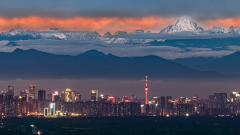
The Sichuan-Tibet Highway, a miraculous route stretching across southwest China, is not only a vital transportation lifeline connecting the Sichuan Basin and the snow-capped Tibetan Plateau but also a world-renowned super scenic corridor. Wandering through the Hengduan Mountains, it crosses surging rivers, threads through vast grasslands, traverses dense forests, and approaches glittering glaciers—gradually transitioning from the mild charm of the Land of Abundance to the majestic grandeur of Tibet.
This road is brimming with unknowns and delights, where every bend reveals breathtaking scenery that touches the soul. A detailed Sichuan-Tibet Highway map serves as the key to unlocking such charm. Clearly marking scenic spots, supply stations, and driving routes along the way, it gives travelers peace of mind as they explore the unknown, allowing them to fully savor the visual feast and spiritual enlightenment brought by this “heavenly road.”
First Impression of the Heavenly Road: The Map Unfolds the Landscape Context of Sichuan-Tibet
Before embarking on the Sichuan-Tibet Highway, it is crucial to understand the basic context of this highway through the Sichuan-Tibet Highway map. The Sichuan-Tibet Highway is usually divided into the North Line and the South Line. The North Line is dominated by cultural landscapes, while the South Line is famous for its natural scenery. The full picture and branches of these two routes are clearly presented on a high-quality Sichuan-Tibet Highway map.
A high-quality Sichuan-Tibet Highway map will mark the starting point of the highway (Chengdu), the end point (Lhasa), and important towns along the way, such as Kangding, Yajiang, Litang, Batang, Mangkang, etc. These towns are important nodes for supplies and rest during the journey, and can be easily found on the Sichuan-Tibet Highway map. At the same time, the map will also mark the total mileage of the route and the altitude changes of major sections, allowing you to understand in advance the geographical reasons for the phenomenon that “there are four seasons in one day, and different sceneries every ten miles”.
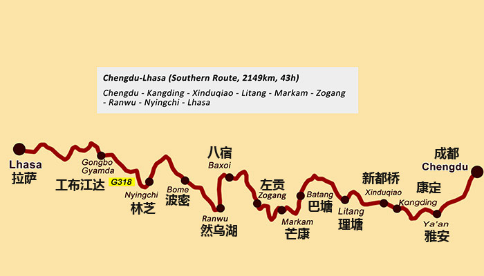
Sichuan-Tibet Highway Map G318
Customize Your Exclusive Journey: Let the Map Be Your Sichuan-Tibet Guide
When planning a Sichuan-Tibet trip, the Sichuan-Tibet Highway map can help you formulate a reasonable route according to your own time and interests. If you have plenty of time and want to experience the customs of western Sichuan and Tibet in depth, the combined loop of the South Line and the North Line is a good choice. By connecting these two routes on the Sichuan-Tibet Highway map, you can plan a perfect itinerary without retracing your steps.
If you are fond of magnificent natural landscapes, the Sichuan-Tibet Highway map will guide you to travel along the South Line. Scenic spots along the way, such as Gongga Snow Mountain, Daocheng Yading, Ranwu Lake, and Yamdrok Lake, are clearly marked on the map. You can reasonably arrange the daily driving time according to the distance between the scenic spots to avoid fatigue driving. For travelers interested in Tibetan Buddhism culture, scenic spots such as Tagong Monastery and Seda Larung Gar Buddhist Academy on the North Line are also clearly visible on the Sichuan-Tibet Highway map, allowing you to easily step into the depths of Tibetan culture.
In addition, some sections of the Sichuan-Tibet Highway are greatly affected by seasons. For example, high-altitude areas such as Dongda Mountain and米拉山口 (Mila Mountain Pass) are prone to snow and ice in winter. A high-quality Sichuan-Tibet Highway map will mark these sections that are vulnerable to weather conditions and remind you of the best travel season, helping you avoid potential risks during the journey.
Tips for a Worry-Free Journey: Scenic Spots and Supply Stations Marked on the Map
The scenic spots dotting the Sichuan-Tibet Highway are relatively scattered, stretching across vast landscapes that span from rolling grasslands to rugged mountain passes. Having a detailed Sichuan-Tibet Highway map at your fingertips allows you to accurately pinpoint the exact location of each attraction and map out the most efficient route to reach them—saving you precious time and avoiding unnecessary detours.
For instance, the scenic branch route from Litang to Daocheng Yading, a paradise renowned for its snow-capped peaks and crystal-clear lakes, is clearly delineated on the map. This enables you to calculate the round-trip travel time in advance, account for possible stops along the way, and seamlessly integrate this detour into your overall journey. By doing so, you can fully immerse yourself in the breathtaking beauty of Daocheng Yading without worrying about falling behind schedule or missing key highlights of your main Sichuan-Tibet itinerary.
In addition to scenic spots, supply information is crucial for long-distance travel. The Sichuan-Tibet Highway map will mark the locations of infrastructure such as gas stations, hospitals, banks, and supermarkets in the towns along the way, enabling you to quickly find corresponding service locations when your vehicle needs refueling, when you need to buy daily necessities, or when you feel unwell. For example, in Litang County, which has a high altitude, oxygen-supplied hotels and hospitals will be marked on the map to provide guarantee for your acclimatization to the plateau.
For travelers who like outdoor camping, suitable camping sites are also marked on the Sichuan-Tibet Highway map. Most of these sites are far from dangerous areas and have basic sanitary facilities, allowing you to enjoy the starry sky and grassland scenery while ensuring accommodation safety.

The Sichuan-Tibet Highway and Its Scenery Along the Route
Tips for Choosing a Map: Fully Secure Your Sichuan-Tibet Journey
When choosing a Sichuan-Tibet Highway map for your journey, it is highly recommended to give priority to the latest version of electronic maps or high-quality printed maps—both tailored to different travel scenarios and needs. Electronic maps such as Google Maps and Amap stand out for their ability to update real-time road conditions, traffic alerts, and even temporary road closures, empowering you to adjust your itinerary promptly in response to unexpected changes like construction or weather-related disruptions.
Printed maps, on the other hand, are indispensable for remote sections of the route where mobile signals are weak or unavailable, serving as a reliable backup that won’t fail due to poor connectivity. They often include detailed topographical markers, scenic spot introductions, and key supply points that electronic versions might omit. By combining these two types of maps—relying on electronic maps for dynamic updates in signal-covered areas and turning to printed maps for stable guidance in remote regions—you can achieve the best possible navigation effect, ensuring a smooth and worry-free exploration of the stunning Sichuan-Tibet Highway.
When using the Sichuan-Tibet Highway map, you should learn to plan your itinerary based on altitude and driving time. The average altitude of the Sichuan-Tibet Highway is over 3,000 meters, and travelers visiting Tibet for the first time are prone to altitude sickness. Therefore, mark the daily altitude changes on the map to avoid a sharp increase in altitude within one day. At the same time, pay attention to the winding and dangerous sections marked on the map, such as the Tongmai Dangerous Section (which has been improved now), and drive slowly when passing through these sections to ensure driving safety.
In addition, you can mark Tibetan restaurants and characteristic homestays along the way on the Sichuan-Tibet Highway map in advance. This allows you to taste local delicacies such as butter tea and highland barley cakes, and experience the unique charm of Tibetan dwellings, making your journey more immersive.
Set Off with a Map: Make Every Section of the Sichuan-Tibet Road Worry-Free
The charm of the Sichuan-Tibet Highway lies in its constantly shifting and breathtaking landscapes—from the lush greenery of the Sichuan Basin to the rugged grandeur of the Hengduan Mountains, and finally to the pure sanctity of the snow-capped plateau. Every stretch of the journey holds hidden surprises waiting to be discovered. A detailed Sichuan-Tibet Highway map is the reliable companion that unlocks this unique allure. Whether you’re a free-spirited self-driving adventurer or a traveler joining a group tour, it serves as the most thoughtful guide for your journey.
Clearly marked on the map are every route, supply station, and rest stop, allowing you to traverse snow-capped mountain roads, wander through lush green grasslands, linger by crystal-clear lakes, and explore deep, precipitous canyons without worrying about itinerary planning. Immerse yourself fully in the emotions stirred by the natural beauty around you. Meanwhile, it will also lead you to Tibetan villages along the way, where you can safely savor the rich aroma of butter tea, feel the passion of Guozhuang dances, and experience the profound Tibetan culture and unique customs.
The Sichuan-Tibet Highway is never merely a transportation artery connecting two regions; it is a spiritual link that weaves together diverse local cultures and countless scenic wonders. Bring this map and embark on this miraculous “heavenly road.” At every turn, you’ll encounter unexpected delights; on every grassland, you’ll feel unrestrained freedom; and atop every mountain peak fluttering with prayer flags, you’ll touch the power of faith. This journey is destined to become an unforgettable and precious memory of a lifetime, and the Sichuan-Tibet Highway map is the perfect starting point for this wonderful experience.