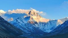
Perched beneath the towering silhouette of Mount Everest, Rongbuk Glacier is one of the high-Himalaya’s most spectacular ice landscapes. Located on the north slope of Everest in Tingri County, Shigatse Prefecture, Tibet, Rongbuk spreads across an alpine amphitheatre of crevasses, ice towers and glacier lakes at elevations that commonly exceed 5,000 metres. For travelers seeking a combination of raw high-altitude scenery, mountaineering history and Tibetan monastic life, Rongbuk is a place that feels sacred, cinematic and fragile all at once.
Geography and Formation of Rongbuk Glacier
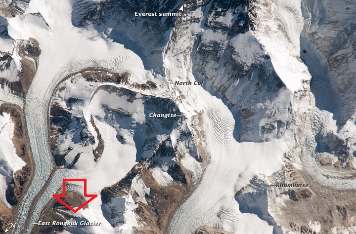
Rongbuk Glacier occupies the north face basin beneath Everest and is the largest glacier system in the Mount Everest area. The glacier complex is composed of three main arms—east, middle and west—which converge in the glacial valley and then flow northwards. The elevation of the glacier ranges roughly from about 5,300 metres up toward 6,300 metres on the slopes feeding the ice field.
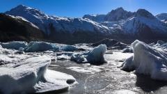
Glaciers are living recorders of climate and geological movement. Rongbuk’s immense ice tongue — measured in kilometres across and tens to hundreds of metres thick — has sculpted the valley over millennia. As the glacier flows and cracks under the pressure of its own weight and the steep gradient, it produces the dramatic features visitors come to see: towering seracs, deep ice clefts, avalanche chutes and small milky moraine lakes that mirror the sky.
Ice Sculptures and Landforms of Rongbuk Glacier
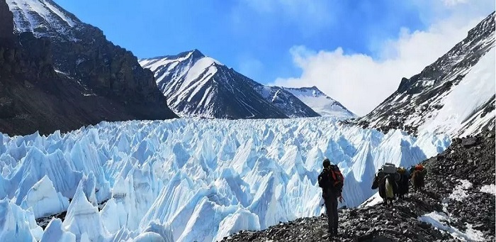
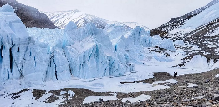
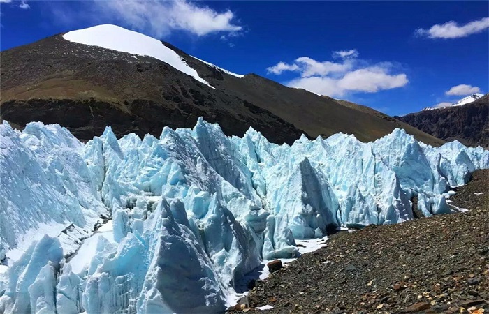
One of Rongbuk’s most memorable traits is the astonishing variety of ice formations. A long belt of ice towers stretches across part of the glacier — a 5.5-kilometre succession of milky pinnacles, some rising tens of metres and taking shapes you might only expect from a fantasy landscape. These formations go by many names—seracs, ice mushrooms, ice chimneys—and they form where the glacier flow fractures and differential melting carves dramatic relief.
You will also find mammoth ice cliffs, hidden crevasses that can look deceptively calm, and ice-carved caves that glint like blue cathedrals in sunlight. In bright weather, meltwater ponds form and act like mirrors between the towers; on windier, colder days the whole valley may be swathed in mist and spindrift, giving the place a truly mystical atmosphere.
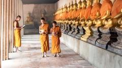
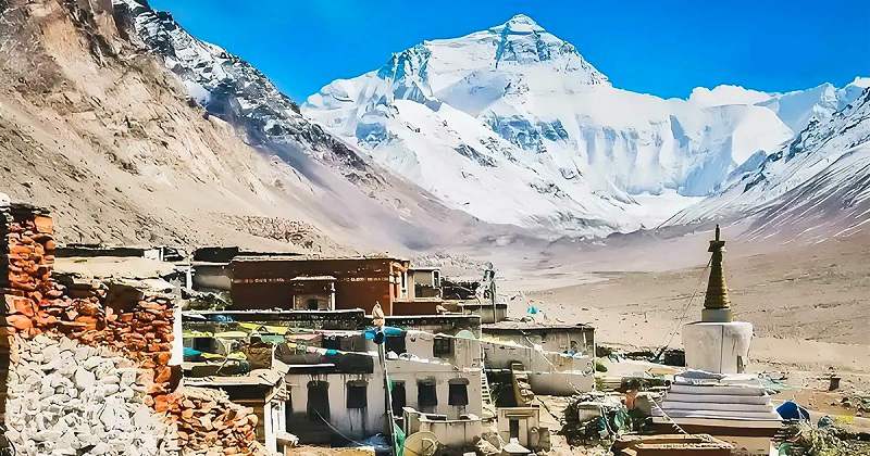
Rongbuk Monastery: Spiritual and Cultural Anchor
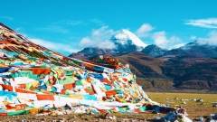
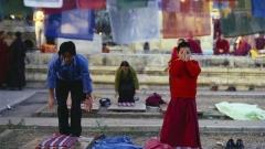
At the northeastern edge of the glacier, clinging to the slopes above the valley, is Rongbuk Monastery — among the highest monastic sites in the world. Founded at the turn of the 20th century, the monastery sits at an altitude above 5,100 metres and serves both as a place of devotion and a base for climbers attempting Everest from the north.
From the monastery’s courtyard you can look south and see Everest rise like a vast pyramid above the glacier. The visual and spiritual juxtaposition — prayer flags fluttering in subalpine wind, robed monks moving between stone buildings, and an enormous glacial valley beyond — is a defining image of Rongbuk. The monastery has long been a site for pilgrims, climbers and photographers, and its presence helps remind visitors that this place is not only geological but deeply cultural.
Rongbuk River and the Story of Retreat
At the glacier’s toe, meltwater streams join to form the Rongbuk River. This ice-fed river is a visible record of glacier dynamics: broad braided channels, sedimentary deposits and exposed boulders mark a hydrological history of fuller, more powerful flows in earlier eras. Observations by researchers and local accounts indicate that Rongbuk—like many high-mountain glaciers—has been receding over decades. The riverbed’s exposed rounded stones and the reduced extent of ice at the glacier’s snout are plain evidence that this ice landscape has changed considerably.
Melting patterns are influenced by factors such as local microclimates, high solar radiation at low latitudes, and the shape of the glacier itself. The glacier’s variable melting creates the very features visitors love — sculpted towers, melt ponds, polished ice — but also signals the sensitivity of these high-alpine environments to climate fluctuations.
How to Reach Rongbuk Glacier
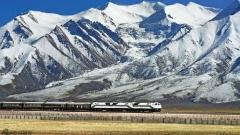
Access to Rongbuk Glacier typically begins from Lhasa or Shigatse as the main Tibetan transport hubs, or from Kathmandu if entering from Nepal and then travelling overland into Tibet. From Tingri County the road climbs toward the Rongbuk valley; the drive itself is part of the experience, passing alpine pastures, yak herds, and gradually thinning air.
Because Rongbuk sits at extreme altitude, most visitors travel with organised groups and experienced drivers. Road surfaces can be rough and the journey may take several hours from the nearest county town. Many visitors combine Rongbuk with a broader north-slope Everest circuit or a pilgrimage itinerary to nearby sacred sites.
Permits, Guiding and Local Regulations
Travel to high-altitude regions of Tibet typically requires permits and local registration. In addition, many areas near Everest require special permissions and must be visited with an authorised guide or through a travel company familiar with regional regulations. Travellers should arrange logistics through a reputable operator that knows the local requirements, acclimatisation schedules and emergency procedures.
For your safety and for respect to local rules, do not attempt to self-drive into restricted areas or visit monastery precincts without permission. Local guides will also help you understand culturally appropriate behaviour inside monastic compounds and at sacred viewpoints.
Flora, Fauna and the Human Presence
At extreme elevations plant life is sparse, but you will still observe hardy alpine species, scattered cushion plants and low grasses that survive seasonal extremes. Wildlife is adapted to thin air: sightings might include Himalayan marmots, blue sheep in distant slopes and a variety of alpine birds. Human presence—nomadic herders, monastery communities and seasonal climbers—shapes the landscape too. Respect local grazing areas and cultural sites.
Health, Acclimatisation and Safety
Rongbuk’s altitude is serious: the monastery and glacier surfaces are well above 5,000 metres. Altitude sickness is the single greatest health risk. Symptoms range from headache and nausea to potentially life-threatening pulmonary or cerebral edema. To reduce risk:
- Allow at least one full day for slow acclimatisation after arriving at a town at 3,000–4,000 metres.
- Climb gradually; avoid sudden altitude gains.
- Stay hydrated, avoid heavy exertion in the first 24–48 hours and limit alcohol intake.
- Learn the early warning signs of severe altitude illness and carry a pulse oximeter if possible.
- Consider carrying emergency oxygen and a plan for rapid evacuation if symptoms worsen.
Weather hazards are also real: crevasses, avalanche slopes and unstable ice are present near the glacier. Keep to marked or well-trodden paths, listen to your guide, and do not venture onto the ice without experienced guidance and appropriate gear.
Packing Checklist
Essentials for a Rongbuk trip include: warm layered clothing for extreme cold, windproof outer shell, sturdy high-altitude boots, sun protection (high SPF sunscreen, sunglasses with UV protection), water purification or reliable bottled water, a good headlamp, first-aid kit with altitude medication (as advised by a physician), extra camera batteries, and a compact travel pillow for better rest at altitude.
Environmental Responsibility and Conservation
High-altitude glaciers are fragile ecosystems and are particularly vulnerable to human impacts and climate change. Travelers should:
- Carry out all rubbish and avoid single-use plastics where possible.
- Keep to established trails and viewpoints; do not disturb ice formations.
- Respect monastic sites, cultural norms and local wildlife.
- Minimise campfire use and ensure any human waste is managed according to local guidelines.
- Support local conservation projects or communities via ethical tourism.
Visiting Rongbuk responsibly ensures that future generations of travelers and local people can continue to experience this extraordinary place.
Common Misconceptions about Rongbuk Glacier
- Rongbuk is not a leisure stroll: it is a high-altitude, remote environment that requires physical preparation, acclimatisation and respect for local rules.
- The glacier is not an unchanging ice sheet: it is dynamic and has been retreating and reshaping over decades. Visiting with a guide, you will see evidence of change in riverbeds, moraine lines and exposed rock.
- Monastery access may be limited during certain ritual periods or weather conditions — always follow local signage and guidance.
Rongbuk is visually dramatic, but its value goes deeper. It is a living laboratory for understanding climate change at high altitude, a spiritual landscape for Tibetan Buddhism, a historical waypoint for Everest pioneers, and a community space for local residents who have lived in the high plateau for generations. For the thoughtful traveler, Rongbuk is a place that provokes reflection on the power of nature, the slipperiness of permanence and the resilience of human spirit at altitude.
Final Planning Tips of Rongbuk Glacier Travel
- Book with a specialist operator experienced in Tibetan high-altitude logistics.
- Prioritise time for acclimatisation and avoid back-to-back rapid altitude gains.
- Check seasonal road conditions and local festival calendars which may affect access.
- Purchase travel insurance that covers high-altitude evacuation and emergency care.
- Travel with curiosity and humility: local communities and monastic custodians hold the most meaningful context for what you see.
If you prefer expert local help to plan a safe, culturally respectful and logistically smooth visit to Rongbuk Glacier and Everest’s north slope, China Dragon Travel specialises in tailor-made Tibet journeys. Our team has deep experience organising high-altitude trips, monastery visits and overland routes while prioritising acclimatisation, safety and sustainable practices. For personalised itineraries that combine natural spectacle, cultural insight and careful logistics, contact us.