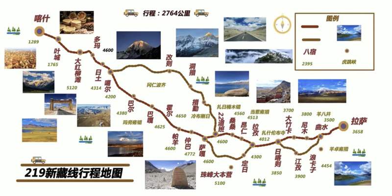
The G219 Xinjiang–Tibet Highway, also known as the Xinjiang–Tibet route, is one of the highest and most demanding roads on Earth. Connecting Yecheng in Xinjiang with Lazi in Tibet, the route spans over 2,100 kilometers at an average elevation above 4,500 meters. Along the way, travelers cross massive mountain passes, vast uninhabited regions, sacred lakes, glaciers, and remote cultural landscapes. More than a transportation corridor, G219 represents an immersive journey through extreme geography and human resilience.
Detailed Breakdown of National Highway G219 Sections – Unlock Unique Scenery Along the Way
National Highway G219 boasts complex road conditions and significant altitude fluctuations. Scenery, elevation, and supply availability vary greatly across sections, so it’s recommended to allocate 7-10 days for a leisurely journey. Below is a detailed breakdown of each section’s core features, highlights, and key notes to help you fully prepare for the trip.
The G219 Xinjiang–Tibet Highway
Lhasa to Lhatse Section: The Transitional Start of Culture and Nature
As the southern starting section of National Highway G219, connecting to National Highway 318, the Lhasa to Lhatse stretch covers about 415 kilometers. With generally smooth paved roads, it’s ideal for travelers to initially acclimatize to the plateau environment. Passing through Shigatse City, you can visit Tashilhunpo Monastery to immerse yourself in the profound Buddhist culture of Western Tibet, making it a crucial transitional section blending humanity and nature. Lhatse, an important node on National Highway G219 at an altitude of 4,050 meters, means “the top where the sun first shines” in Tibetan. The Yarlung Tsangpo River flows gently beside it, and though the county seat is small, it offers complete facilities including restaurants and hotels. It’s a perfect resting point for first-time plateau travelers to adapt to the climate and the official starting point of National Highway G219’s core sections.
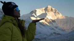
Lhatse to Saga Section: Distant Views of Everest and First Encounter with Sacred Lakes
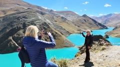
Covering approximately 300 kilometers, the Lhatse to Saga section requires transferring from National Highway 318 to National Highway G219. With excellent road conditions, it passes through neat Tibetan villages and offers broad vistas, allowing you to stop and admire plateau pastoral scenery at will. The highlight of this section is the multiple Everest viewing platforms, where you can gaze at the magnificent northern foot of Mount Everest. You’ll also encounter the stunning scene of Lake Peiku and Mount Shishapangma framed together – the lake’s blue waters mirror the towering snow-capped mountains, creating breathtaking photos. Saga County, at an altitude of 4,500 meters with a population of around 16,000, is a must-pass on National Highway G219 and a key supply station before entering Ngari Prefecture. It features complete hotels, restaurants, and a newly built RV camp, providing a clean and safe resting place for travelers.
Saga to Mount Kailash Section: The Gateway to Ngari’s Secrets
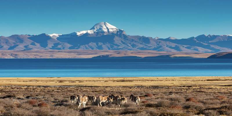
Stretching about 490 kilometers, the Saga to Mount Kailash section officially enters Ngari Prefecture. It’s one of National Highway G219’s most representative scenic sections, with increasingly primitive and magnificent landscapes where grasslands, Gobi, and snow-capped mountains interweave, showcasing the plateau’s vastness and grandeur. Along the way, you’ll pass Zhongba County Martyrs Cemetery, where you can pause to pay tribute to martyrs who sacrificed their lives to defend the border and feel a sense of national pride. You’ll also see Jima Yangzong Glacier, the source of the
Yarlung Tsangpo River, where trickles converge into a mighty river, witnessing the magic of nature. The endpoint, Saga Town in Pulan County, is adjacent to Mount Kailash Base Camp at an altitude of 4,600 meters – the best spot to admire the sacred Mount Kailash. Simple homestays and parking areas are available nearby, allowing travelers to experience the mountain’s solemnity up close.
Mount Kailash
Mount Kailash to Shiquanhe Section: The Core Feast of Sacred Mountains and Lakes
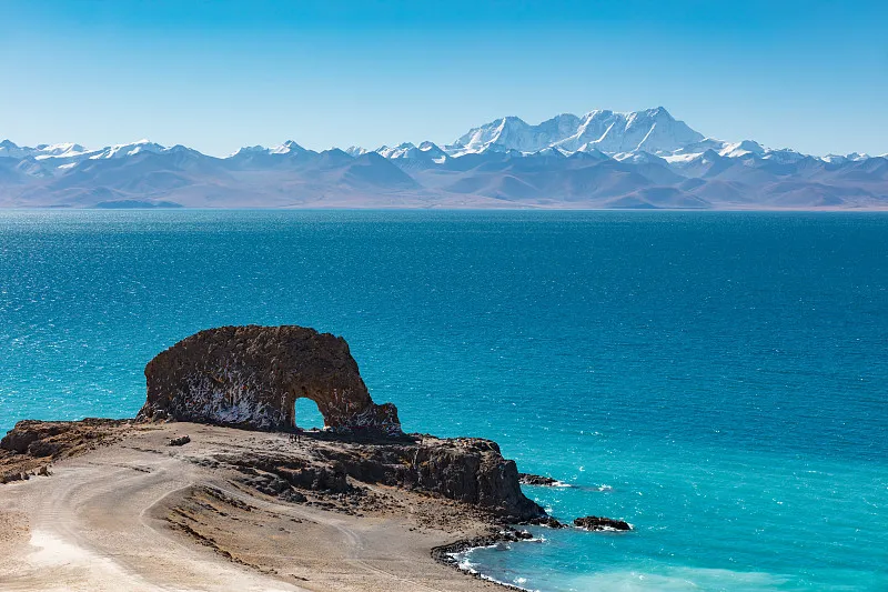
Covering around 245 kilometers with smooth road conditions, the Mount Kailash to Shiquanhe section gathers National Highway G219’s core cultural and natural landscapes, making it a must-experience for all travelers. Along the way, you can visit Lake Manasarovar (“Sacred Lake”), hailed as the “Jade Pool of the West” and China’s most transparent lake. Its blue waters, like jade, contrast with the adjacent Lake Rakshastal (“Demon Lake”), forming a unique scene of “one sacred, one demonic” – both equally charming, inviting you to immerse yourself in their purity and holiness. As the administrative center of Ngari Prefecture, Shiquanhe Town sits at 4,200 meters above sea level with complete facilities including restaurants, hotels, gas stations, and hospitals. It’s the primary resting and supply hub in Ngari and a crucial preparation point for crossing the subsequent no-man’s land.
Shiquanhe to Duoma Township Section: Encountering Life in No-Man’s Land
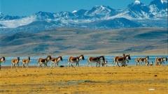
The 230-kilometer Shiquanhe to Duoma Township section, mainly traversing parts of the Changtang no-man’s land, is an excellent spot to encounter plateau wildlife. Though short, the route offers extremely broad views, fully displaying the desolate beauty of the plateau desert. Herds of Tibetan wild asses, gazelles, and other wildlife are often seen, creating spectacular scenes – travelers can take photos from a safe distance to capture the vitality of plateau life. Note that Duoma Township has a high altitude and simpler facilities compared to Shiquanhe Town, with limited supply options that only meet basic resting and material needs, serving as a temporary stop during short-distance travel.
Duoma Township to Da Hongliu Tan Section: The Ultimate Challenge at the Top of the Sky Road
Covering approximately 300 kilometers, the Duoma Township to Da Hongliu Tan section is one of National Highway G219’s highest and most challenging stretches. It crosses Jiashan Pass (China-Nepal border) at an altitude of 6,035 meters – the highway’s highest point. Standing atop the pass, you can overlook the plateau mountains, feeling the grandeur of “seeing all mountains small,” and it also marks the geographical boundary between Xinjiang and Tibet, holding great commemorative significance. Parts of this section are no-man’s land with no gas stations or supply points. While road conditions are generally acceptable, extra caution is required when driving. Ensure your fuel tank is full in advance and carry sufficient drinking water and food. Da Hongliu Tan has a high altitude and basic facilities, mainly simple homestays and parking areas, suitable for short rests to adapt to higher altitudes before crossing the no-man’s land.
Da Hongliu Tan to Yecheng Section: A Perfect Conclusion to the Sky Road Journey
The 300-kilometer Da Hongliu Tan to Yecheng section is National Highway G219’s northern endpoint and a stretch where altitude gradually decreases. Road conditions become smoother, allowing travelers to slowly adapt to lower altitudes and alleviate altitude sickness discomfort. The route passes through Kudi Pass, Maza Pass, and other areas with relatively complex road conditions – winding and cliffside – requiring careful driving. However, the scenery remains charming, with Gobi, snow-capped mountains, and river valleys interweaving to showcase the unique style of Xinjiang’s plateau. As the northern starting point of National Highway G219, Yecheng County offers complete facilities including restaurants, hotels, and gas stations, and is an important town in Kashgar Prefecture, Xinjiang. Travelers can rest well here, experience Xinjiang’s customs, and taste local specialties, drawing a perfect end to the entire National Highway G219 journey.
Essential Items for Starting Your Xinjiang-Tibet Highway Journey
With high altitudes, harsh climates, and inconvenient supplies along National Highway G219, preparing various items in advance can effectively cope with unexpected travel situations and ensure comfort and safety. Below is a comprehensive checklist for travelers to supplement based on their individual needs.
Essential Documents
ID card, driver’s license, and vehicle registration certificate are mandatory – multiple checkpoints along the way will conduct strict inspections. The border defense permit is crucial: it’s recommended to apply for it in advance at the police station in your place of household registration, specifying Shigatse City, Ngari Prefecture, and Kashgar Prefecture to avoid delays during the trip. A valid ID card is required for application, and no fees are charged.
Clothing Essentials
Temperature differences on the plateau are extreme – daytime temperatures can exceed 20°C under intense sunlight, while nighttime temperatures can drop below -10°C. Prepare warm, windproof, and sun-protective clothing: recommended items include冲锋衣 (hard-shell jackets), down jackets, thermal underwear, thick woolen socks, windproof pants, sun hats, sunglasses, scarves, and gloves. Choose high-top hiking shoes or waterproof, warm outdoor shoes to avoid frostbite and sunburn.
Medical Supplies
Altitude sickness medications are essential: carry Gaoyuan’an (plateau adaptation medicine, no need to take in advance – start on the departure day), acetazolamide (to prevent cerebral edema), and ibuprofen (to relieve altitude sickness-induced headaches). Also prepare cold medicine, antipyretic medicine, gastrointestinal medicine, motion sickness medicine, band-aids, and alcohol pads. Travelers with sensitive stomachs can bring additional Gaoyuan’an probiotics to cope with acclimatization issues. It’s advisable to carry portable oxygen cylinders, especially for travelers with weaker physical conditions, for emergency use.
Daily Necessities
The plateau climate is dry – carry moisturizer, hand cream, and lip balm to prevent dry skin and chapped lips. Choose sunscreen with SPF50+ and PA++++ for full protection. Bring a large-capacity thermos – most water along the way is melted snowwater, which is not safe for direct drinking, so prepare sufficient drinking water in advance or carry water purification tablets. Also pack wet wipes, garbage bags, power banks, and flashlights. Garbage bags must be properly stored – littering is strictly prohibited along the entire route to protect the plateau ecosystem.
Other Supplementary Items
Carry high-energy, easy-to-store snacks such as chocolate, beef jerky, compressed biscuits, and nuts to replenish energy at any time due to inconvenient supplies. Bring navigation equipment including mobile phone navigation and on-board navigation – mobile phone signals are unavailable in some no-man’s land areas, so it’s recommended to carry a satellite phone or offline maps. Self-driving travelers should additionally bring vehicle emergency tools such as tow ropes, electric air pumps, and off-road recovery boards.
Important Notes for the Xinjiang-Tibet Highway
National Highway G219 is a road full of challenges and charm. While the journey is beautiful, safety and respect for local culture must be prioritized. Remember the following notes to ensure a smooth trip.
Altitude Sickness Response Guide
With an average altitude exceeding 4,500 meters, oxygen levels on National Highway G219 are only 44% of those in inland areas. Altitude sickness is a common issue for all travelers – there’s no need for excessive panic, but proper precautions are essential. Avoid strenuous exercise such as running or jumping when first arriving on the plateau, drink plenty of water, rest more, eat light meals, avoid alcohol and overeating, and ensure adequate sleep (sleep is the best way to cope with altitude sickness). If severe altitude sickness symptoms occur (difficulty breathing, chest tightness, persistent vomiting, confusion), immediately stop the trip, use oxygen to relieve symptoms, and seek medical treatment at a nearby hospital if necessary. Shiquanhe Town and Yecheng County have relatively complete medical facilities.
Driving Safety Tips
Road conditions along the way are complex – some sections are cliffside, winding, with hidden pits and snow. Strictly control vehicle speed, avoid fatigue driving (drive no more than 8 hours a day), and allocate 1-2 flexible days to handle emergencies. Don’t get anxious if delayed by road construction – take the opportunity to admire the scenery and observe wildlife. Travel in groups in no-man’s land sections and avoid driving alone. Maintain a safe distance of over 80 meters from wildlife, do not approach or chase them, and never provoke dangerous animals such as wild yaks and brown bears.
Cultural Taboo Guidelines
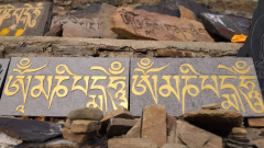
National Highway G219 passes through areas mainly inhabited by Tibetans and Uyghurs – respect local religious beliefs and customs. When visiting temples, do not wear shorts or miniskirts, avoid loud noises and photography, take off hats and sunglasses, and follow the temple’s relevant regulations. Communicate with local residents in a friendly and humble manner, avoid sensitive topics, and do not disturb or photograph pilgrims – patiently give way to them. When circumambulating sacred lakes such as Lake Manasarovar, follow the local pilgrim tradition by moving clockwise.
Weather and Environmental Protection Notes
Weather along National Highway G219 is unpredictable – even in summer, extreme weather such as snowfall, heavy rain, and strong winds may occur. Check the weather forecast for the route before departure, prepare emergency items, and stop driving to take shelter in case of severe weather. The plateau ecosystem is fragile – littering is strictly prohibited along the entire route, and checkpoints will randomly inspect on-board trash cans. Properly store garbage and dispose of it in towns with waste treatment facilities. Do not pick plateau vegetation or hunt wildlife – jointly protect this pure land.
Other Friendly Reminders
Mobile phone signals are unavailable in some sections – inform your family of your itinerary in advance to avoid worrying them. Supply points are far apart – prepare sufficient drinking water and food in advance and do not wait until supplies are exhausted to look for replenishments. From November to April of the following year (winter), some sections of National Highway G219 are closed due to heavy snow, so travel is not recommended. The best travel time is from May to October, when the climate is relatively mild and road conditions are more stable.
Preparing for a Safe and Meaningful Journey on the G219 Highway
Traveling the G219 Xinjiang–Tibet Highway requires more than curiosity—it demands respect for altitude, distance, and environmental extremes. With limited infrastructure and long stretches of uninhabited land, success on this route depends on realistic planning, physical awareness, and reliable logistical support. For travelers who prefer a structured and secure approach, working with experienced specialists such as China Dragon Travel helps ensure that road conditions, altitude adaptation, and regional regulations are properly managed. With adequate preparation and professional guidance, the G219 becomes not just a challenging road, but a profoundly rewarding journey across one of the world’s most extraordinary landscapes.