For travelers venturing into the southwest gem of China, Yunnan, a map replete with meticulous details is the key to a dreamy journey. Yunnan, a land woven with a rich diversity of landscapes and cultures, may prove to be a mesmerizing maze to those unfamiliar with its ways. A carefully drawn map is crucial for a meaningful and immersive experience. This guide will assist you in turning flat cartographic symbols into a vivid, three-dimensional travel plan, guaranteeing an unforgettable and remarkable sojourn in Yunnan.
The Geographic and Cultural Puzzle on a Yunnan Province Map
The information presented on a standard map of Yunnan Province goes far beyond imagination. First, we need to understand its geographic framework from a macro perspective. Yunnan’s overall terrain is high in the northwest and low in the southeast. The significant elevation difference directly shapes vastly different climates and landscapes. On the map, you can clearly see the Hengduan Mountains running vertically through the western part, where iconic peaks like Meili Snow Mountain and Yulong Snow Mountain stand tall. The southeastern part gradually transitions to hilly and karst landscapes, such as the famous Puzhehei and Bamei.
Secondly, cultural divisions provide another clue to understanding the map. Place names on the map often conceal codes of history and ethnicity:
- Northwest Yunnan (Shangri-La, Lijiang, Diqing): Located in the upper left corner of the map, this area is an extension of the Tibetan Plateau, characterized by Tibetan culture, magnificent snow mountains (like Meili Snow Mountain), and highland lakes (like Lugu Lake).
- Western Yunnan (Dali, Baoshan, Tengchong): Along the western part of the map, this region is famous for the Bai ethnic culture around Cangshan Mountain and Erhai Lake, the historic Ancient Tea Horse Road, and Tengchong’s volcanic geothermal features.
- Central Yunnan (Kunming, Yuxi, Chuxiong): The central part of the map, where the provincial capital Kunming is located. It serves as a transportation hub with a pleasant climate and features classic attractions like the Stone Forest.
- Southwest Yunnan (Xishuangbanna, Pu’er): Located in the lower right corner of the map, this area enters the tropical zone, filled with Dai ethnic culture, pristine rainforests, and Pu’er tea mountains.
- Southeast Yunnan (Wenshan, Honghe): Highlights include the Yuanyang Rice Terraces, the idyllic waterside scenery of Puzhehei, and the cultures of the Zhuang and Miao ethnic groups.
Understanding these regions helps you quickly locate your areas of interest on the map and plan a logically clear travel route.
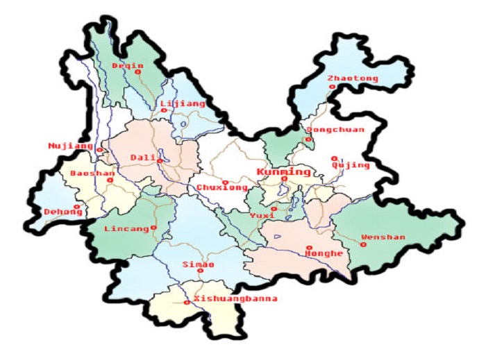
Yunnan Map
The Lifelines on the Map: A Complete Analysis of Yunnan’s Transportation Network
The core of itinerary planning lies in connecting destinations, and the crisscrossing transportation lines on the map are your lifelines. Modern transportation in Yunnan is very convenient, but due to its mountainous terrain, point-to-point travel still requires time.
- Air Hubs: Kunming Changshui International Airport is the absolute center, handling the vast majority of international and domestic flights. Additionally, airports in Lijiang, Xishuangbanna (Jinghong), Dali, and Diqing (Shangri-La) are suitable for quick jumps within the province to save time. Marking these airport locations on the map is the foundation for planning long-distance travel.
- Railway Network: High-speed rail is reshaping travel in Yunnan. From Kunming, bullet trains conveniently reach Dali, Lijiang, Jianshui, Mengzi, and other places, offering comfort and punctuality. When planning, checking the railway lines on the map (usually marked with thick white or colored lines) allows you to design efficient “bullet train + local tours” combinations.
- Road System: Highways (like the Kunming-Dali-Lijiang route) connect major cities. More provincial and county roads lead to off-the-beaten-path destinations like Yubeng, Bingzhongluo, and Nuodeng. When you see these winding mountain roads on the map, it means you need to allocate more time for the journey and consider chartering a car or joining a local small group tour.
Skillful Tool Use: Practical Tips for Digital and Paper Maps of Yunnan Province
In the era of smartphones, digital maps (like Google Maps, or within mainland China, apps like Gaode Maps or Baidu Maps) are undoubtedly the most convenient, providing real-time navigation, traffic queries, and location reviews. However, a waterproof paper map of Yunnan still holds irreplaceable value: it helps you build a macro geographic understanding, remains reliable in network-less mountainous areas, and serves as an excellent souvenir after the journey.
Usage suggestions:
- Mark Key Points: Mark planned accommodations, transport hubs (airports, train stations), must-visit attractions, and desired restaurants on the map to get an intuitive sense of their distribution density and distances.
- Estimate Travel Time: Use the map’s scale to roughly estimate point-to-point distances, then combine with road conditions (highway vs. mountain roads) to anticipate travel time. This helps arrange daily schedules reasonably and avoid being overly rushed.
- Discover Unexpected Delights: Sometimes, small towns or nature reserves between two major attractions on the map may hide scenery undisturbed by large tourist crowds. Consider leaving some flexible time to explore these “blank areas.”
Practical Planning: Using a Yunnan Province Map to Design Your Perfect Itinerary
Now, let’s put map knowledge into practice. Below are several classic route concepts planned using a Yunnan Province map, based on different themes and durations. You can adjust and combine them according to your situation.
Route 1: Classic Nature & Culture Panorama Tour
This route follows the geographic trend, traveling from north to south to experience diversity.
1.Start in Kunming: Acclimate to the altitude, visit the Stone Forest or Dianchi Lake.
2.Take the bullet train north to Dali (approx. 2 hours): Experience Bai culture by Cangshan Mountain and Erhai Lake, stay for 2 days.
3.Continue by bullet train or car to Lijiang (approx. 2-2.5 hours): Explore Dayan Old Town, using Lijiang as a base.
4.Deepen exploration from Lijiang: Choose to go hiking in Tiger Leaping Gorge, or visit Lugu Lake to experience Mosuo culture (each approx. 3-4 hours drive). A more challenging option is heading to Shangri-La (Diqing) and Meili Snow Mountain, requiring an additional 4-5 days and suitable for those with ample time.
5.Fly from Lijiang to Xishuangbanna (Jinghong): Experience a completely different tropical atmosphere, visit botanical gardens and Dai villages, and enjoy the food.
6.Depart from Xishuangbanna or return to Kunming.
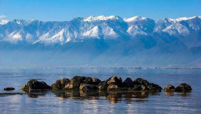
Scenery of Cangshan and Erhai in Dali
Route 2: Southeast Yunnan Photography & Pastoral Poetry Tour
Focus on the stunning scenery of the Honghe and Wenshan regions.
1.Start from Kunming, rent a car or charter a car heading south.
2.Head to Jianshui Ancient Town: Experience history, culture, and delicious food.
3.Venture into the Yuanyang Rice Terraces: Stay in different villages (like Duoyishu, Bada) to capture sunrise and sunset, creating photographic masterpieces with light and shadow.
4.Travel to Puzhehei in Qiubei County, Wenshan Prefecture: Experience the waterside countryside, boat through lotus ponds, as if stepping into a traditional Chinese landscape painting.
5.Optionally extend to Bamei, visiting this “Shangri-La” accessible only by boat through a cave.
6.Return to Kunming.
Route 3: West Yunnan Hot Springs & Border Culture Tour
Explore a relatively niche but highly distinctive route.
1.Fly from Kunming to Baoshan or Mangshi.
2.Focus on Tengchong: Immerse yourself in the tranquility of Heshun Ancient Town, visit the Volcanic Geopark, and be sure to experience the natural hot springs.
3.Travel to Ruili: Experience the unique Sino-Myanmar border culture, visit sites like “One Village, Two Countries.”
4.Choose to return via Dali or directly from Mangshi.
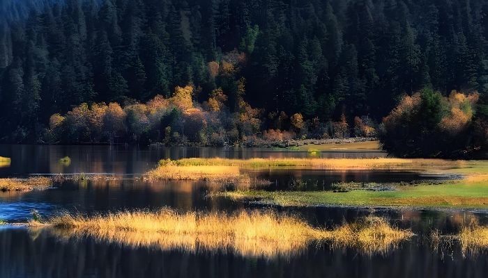
Autumn scenery of Shangri Lepitacuo National Park
Yunnan Travel Practical Advice and Planning
Deliberately orchestrating a meaningful voyage across Yunnan is akin to assembling a delicate jigsaw, with the Yunnan Province map serving as the master template that dictates the arrangement of each intricately shaped piece. In the midst of your preparations, the distinctive allure of Yunnan becomes palpable in every nook: the effervescent flora of Kunming, the serene dance of Cangshan Mountain and Erhai Lake in Dali, the timeless allure of Lijiang Old Town—each locale a vital segment of the puzzle, irreplaceable. Yet, to mold an impeccable travel escapade, expert advice is imperative. In your planning phase, should you require more seasoned route recommendations or logistical assistance, it would be prudent to turn to seasoned entities such as YuLong Travel Agency. They are adept at curating an itinerary that aligns with your preferences, schedule, and travel prerequisites, ensuring your Yunnan sojourn truly dazzles.