Welcome to this complete guide to the Xinjiang Map – written for international travelers who want a practical, map-based understanding of China’s vast far-west. Below you’ll find clear explanations of Xinjiang’s geography and borders, a city-by-city orientation, the major airports and rail hubs that appear on most Xinjiang transportation maps, a curated list of must-see attractions organized by region, climate and travel-season guidance, safety & culture tips, and creative ways to use maps to plan meaningful time in Xinjiang.
Xinjiang Location Map: Where Is Xinjiang Located On A Map?
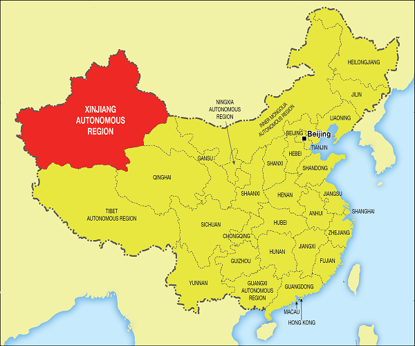
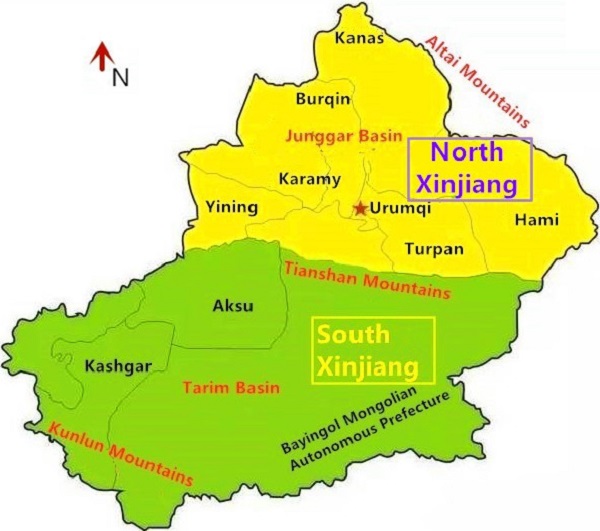
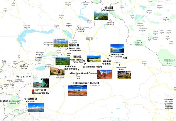
When you pull up a Xinjiang location map, you’re looking at the northwestern edge of the People’s Republic of China. Xinjiang (officially the Xinjiang Uygur Autonomous Region) sits at the crossroads of Central and East Asia. Its scale is hard to overstate: the region covers about one-sixth of China’s land area and rivals many countries in size — that’s why a single map of Xinjiang often needs inset maps or multiple zoom levels to be useful. Major geographic anchors that should appear on any good Xinjiang map include the Tarim Basin and Taklamakan Desert in the south, the Dzungarian Basin in the north, and the Tian Shan and Kunlun mountain ranges along the region’s edges.
Xinjiang’s international borders touch eight countries: Mongolia, Russia, Kazakhstan, Kyrgyzstan, Tajikistan, Afghanistan, Pakistan and India – this is essential context for travelers using border-area maps or planning multi-country overland journeys.
Xinjiang Location Map
Xinjiang Map With Major Cities
Below is a practical guide to the cities you’ll see on any useful Xinjiang map. For each city I’ll explain its travel value, what you’ll find there, and how it fits into an overall route.
Urumqi — The Regional Capital And Transport Hub
Urumqi is Xinjiang’s administrative capital and the main gateway for many international visitors. Urumqi Diwopu International Airport functions as the region’s primary aviation hub; it connects Xinjiang with major Chinese cities and selected international routes. The city mixes modern urban life (malls, museums) with easy access to natural attractions such as Heavenly Lake (Tianchi) to the east. Urumqi is where most international flights and long-distance trains concentrate, so it’s usually the best place to begin exploring on a Xinjiang map.
Kashgar — Silk Road Soul & Market Culture
Kashgar is often described as the living heart of the Silk Road — its Old City, historic mosques and famous Sunday Bazaar (a sprawling market) make it culturally invaluable. On a Xinjiang tourist map, Kashgar anchors the far southern Silk Road circuit and is the starting point for visiting historic sites and local handicraft centers.
Turpan — Ancient Oasis In A Depression
Turpan sits in a low-lying depression and is famous for its heat, ancient ruins, the Karez irrigation system, and vineyards — look for the Flaming Mountain and Grape Valley on any Turpan map. Because Turpan is below sea level, its landscape and agriculture are unique; a Xinjiang map will often include elevation markers to show how deeply the depression sits.
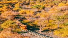
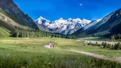
Kanas / Burqin — The Northern Alpine Gem
Kanas Lake and the surrounding villages (Hemu, Burqin) show up on the northern maps of Xinjiang. This area is marked by alpine scenery: pine forests, mirror lakes, and wooden villages — a striking contrast to the southerly deserts.
Korla / Kuqa / Hotan / Karamay — Regional Gateways
- Korla and Kuqa are major northern/southern crossroads, often appearing on travel maps as hubs for the Tianshan and Tarim areas.
- Hotan (Hetian) is famous for jade and silk, and it anchors southern Silk Road stops on many Xinjiang maps.
- Karamay is the oil town known for unusual geological formations like the “Ghost City” near Urho.
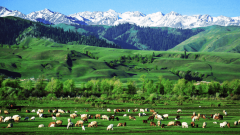
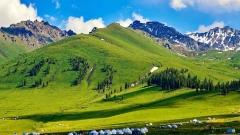
Ili / Yining / Nalati — The Green West
The Ili region (including Yining and Nalati) appears on maps as a verdant area with lakes and pastures — often called “Little Switzerland” for its rolling hills. Sayram Lake and Nalati Grassland are key markers here.
Xinjiang Map With Major Cities
Xinjiang Tourist Map: Top Attractions By Region
Xinjiang’s attractions are widely dispersed; a good tourist map groups them by region to avoid impossible transit plans.
Northern Xinjiang Attractions
- Kanas Lake: Alpine scenery, forests, and ethnic Tuva and Kazakh culture.
- Tianchi (Heavenly Lake): High-altitude lake in the Tian Shan range near Urumqi.
- Wucaitan (Five-Colored Beach): Colorful sandstone formations near Burqin/Kanas.
- Keketuohai National Geological Park & Dushanzi Grand Canyon: Rugged rock formations and dramatic canyons that are obvious highlights on a geological or tourist map.
Eastern Xinjiang Attractions
- Turpan Depression: Flaming Mountain, Karez irrigation tunnels, ancient cities of Gaochang and Jiaohe.
- Grape Valley: Vineyards and fruit markets — a map will show farming belts around Turpan.
Southern Xinjiang Attractions (Silk Road Heart)
- Kashgar Old City & Sunday Bazaar: A cultural epicenter for Uyghur crafts, textiles, and food.
- Kuqa Grand Canyon & Tashkurgan Stone City: Historic ruins and remote stone fortresses on many maps of southern Xinjiang.
- Hotan (White Jade River): Jade markets and desert fringes.
Ili & Altay (Western/Borderlands)
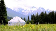
- Sayram Lake: High alpine lake with reflective waters.
- Nalati Grassland: Summer pastures and horse culture.
- Borderland scenery: Maps show the proximity to Kazakhstan and Kyrgyzstan, which matters for cross-border exploration.
Xinjiang Tourist Map
Xinjiang Map With Airports & Train Stations
Xinjiang’s size makes air and rail the best way to cross large distances. By the end of 2023, Xinjiang had 25 civil transport airports — more than any other provincial-level region in China — which means there are many possible entry and exit points depending on what you plan to see.
Major Airports You’ll See On Any Xinjiang Airports Map
- Urumqi Diwopu International Airport (URC): Main international gateway and domestic hub.
- Kashgar (Kashi) Laining International Airport: Southern international gateway near the Silk Road towns.
- Turpan Jiaohe Airport, Burqin Kanas Airport, Korla Licheng Airport, Hotan Kungang Airport, Kelamayi Guhai Airport, Yining Airport, Xinyuan Nalati Airport, Tashkurgan Hongqilafu Airport: These regional airports appear on detailed Xinjiang airports maps and make reaching remote attractions far easier than long coach rides.
Main Railway Stations And Rail Corridors
Rail is practical for major city-to-city hops: Urumqi, Kashgar (part of the southern rail expansion), Turpan, Kuqa, and Yining are the principal nodes. The high-speed rail network is expanding but still less dense than eastern China — maps show the key conventional and high-speed corridors linking Xinjiang to Lanzhou, Xi’an, and beyond. If your travel map includes train times, match them against seasonal schedules.
Visa & Entry for Xinjiang Travel: What The Maps Don’t Tell You
China’s visa and transit rules have evolved since 2022–2026 with policies designed to encourage tourism. Starting in December 2024, transit passengers from 54 countries will be able to stay visa-free for up to 10 days. Travelers from France, Germany, Italy, Spain, and several Asian countries will be able to enjoy a 30-day visa-free stay until 2026. Holders of US, UK, and Canadian passports can stay visa-free for 6 days.
Read More: China Tour Visa Guide & Comprehensive China Visa-Free Policies
Climate & When To Go to Xinjiang
Xinjiang’s climate changes dramatically across regions — desert heat in Turpan, alpine chill by Kanas — so timing matters. Below is a three-column table (optimized for mobile) with the best months and typical temperature ranges for representative points. (These are general seasonal ranges; consult local forecasts for exact values before packing.)
| City / Region | Best Months To Visit | Average Temp Range (Typical) |
|---|---|---|
| Urumqi / Northern Plains | May–October | 10°C – 28°C |
| Turpan (Depression) | April–June, Sept–Oct | 20°C – 38°C (very hot in mid-summer) |
| Kashgar / Southern Silk Road | April–October | 15°C – 33°C |
| Kanas / Burqin (Alpine) | June–September | 5°C – 20°C |
| Ili / Nalati | June–September | 10°C – 25°C |
This table helps mark seasons on a route map: deserts (hot & dry), highlands (short summer window), and northern lakes (best in summer).
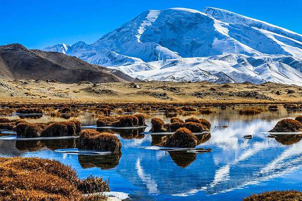
Xinjiang Karakul Lake
Quick Recap: Five Xinjiang Map Facts To Remember
- Xinjiang is huge — roughly 1.6 million km², one of China’s largest administrative regions.
- It touches eight countries, so border landmarks on a map matter for cross-border travel.
- Xinjiang now has 25 civil transport airports, making air travel a practical choice to connect distant highlights.
- Visa and transit rules have changed recently — check official consular updates before you travel.
- Cluster visits regionally — map-based clustering reduces wasted travel time and lets you enjoy deeper cultural experiences.

![11 Day Tour[Winter Limited] Drunken Beauty Xinjiang Ice and Snow Kanas Fairy Tale New Vision](https://www.chinadragontravel.com/wp-content/uploads/2025/12/25cff76cef9e445-240x135.jpg)