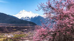
What are the best trekking routes in Tibet? This is one of the most frequently searched questions by adventure travelers planning a journey to the Himalayas. Known as the “Roof of the World,” Tibet captivates explorers with its pristine skies, sacred lakes, towering snow-capped peaks, and profound spiritual heritage. Trekking across this extraordinary land offers an unparalleled way to connect with its raw beauty and timeless culture. From the sacred pilgrimage around Mount Kailash to the breathtaking Everest East Face and the beginner-friendly trails of Kula Kangri, each route presents a unique blend of challenge, scenery, and cultural depth.
Kailash Kora: A Sacred Pilgrimage to the World’s Spiritual Heart
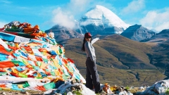
Among all Tibet’s hiking trails, the Kailash Kora holds an irreplaceable status as one of the most revered pilgrimage routes in the world. Standing at 6,656 meters, Mount Kailash is not the highest peak in Tibet, but it serves as a sacred spiritual anchor for multiple religions, drawing devotees from across the globe. For hikers, this journey is far more than an outdoor adventure—it is a transformative experience that cleanses the soul and fosters deep respect for nature.
Route Overview
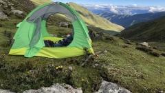
The entire kora (circumambulation) spans approximately 52 kilometers. While the distance is not excessive, the high altitude means most hikers complete it in 2 to 3 days. Starting and ending in the small town of Darchen, the trail passes through iconic sites including the Prayer Flag Square, Choku Monastery, Drirapuk Monastery, the Sky Burial Site and the Drolma La Pass. Each location offers unique scenery and profound cultural significance, immersing you in the pure, sacred atmosphere of Tibet.
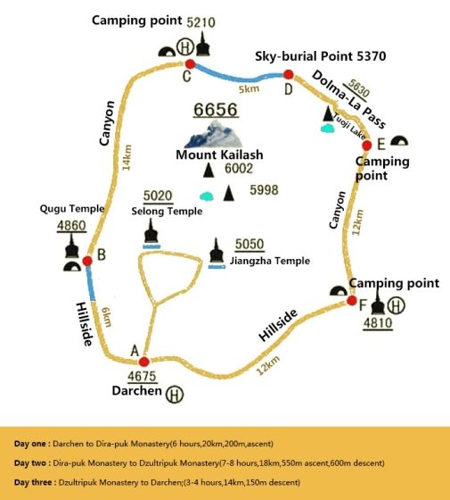
Mount Kailash Kora Route Map
Best Time to Hike
The kora is accessible from May to October, with June to September being the optimal period. During these months, the weather is milder, road conditions are better, and extreme weather is less likely, ensuring a more comfortable and enjoyable pilgrimage or hiking experience.
Difficulty Level
Moderate to challenging. The highest point, Drolma La Pass, reaches 5,630 meters, placing significant demands on physical stamina and altitude acclimatization. The thin air makes even short walks tiring, so inexperienced hikers should not attempt this route without proper preparation and prior altitude adaptation.
Key Highlights
The most striking feature is the intense religious atmosphere. You will encounter countless pilgrims prostrating themselves along the trail, measuring the sacred path with their bodies—a display of devotion that is deeply moving. Additionally, you will enjoy up-close views of Mount Kailash, particularly at sunrise when golden sunlight bathes the snow-capped peak in a breathtaking glow. The trail is lined with prayer flags, mani stones and Tibetan nomad tents, offering an authentic glimpse into traditional Tibetan culture.
Itinerary Suggestion
Beginners should opt for the 3-day itinerary to allow their bodies to acclimate gradually. On Day 1, hike from Darchen to Drirapuk Monastery (22 km), a relatively easy section that helps you adjust to the altitude. Day 2 is the most challenging, as you cross Drolma La Pass before descending to Zutulpuk Monastery (another 22 km). On Day 3, return to Darchen via an 8 km trail, taking your time to soak in the final views before concluding your pilgrimage. Experienced hikers with good stamina can complete the kora in 2 days.
Everest East Face & Gama Valley: The World’s Most Beautiful Valley
Renowned for its unparalleled natural beauty, the Everest East Face and Gama Valley trail is often called the “world’s most beautiful valley” and is undoubtedly one of Tibet’s best hiking routes. Unlike Mount Kailash, it is not famous for religious significance, but it captivates hikers with its pristine wilderness. The valley is home to four 8,000-meter peaks, and the landscape features a stunning mix of ancient forests, alpine meadows and glacial lakes. Walking through this untouched paradise feels like stepping into a forgotten world, where every turn reveals a new awe-inspiring sight.
Route Overview
The trail covers approximately 70 kilometers and typically takes 7 to 8 days to complete. It starts in Qudang Township, and hikers can choose to end in Chentang Town or return to Qudang Township. Returning allows you to revisit your favorite scenic spots, while ending in Chentang Town offers a unique glimpse into the region’s border culture.
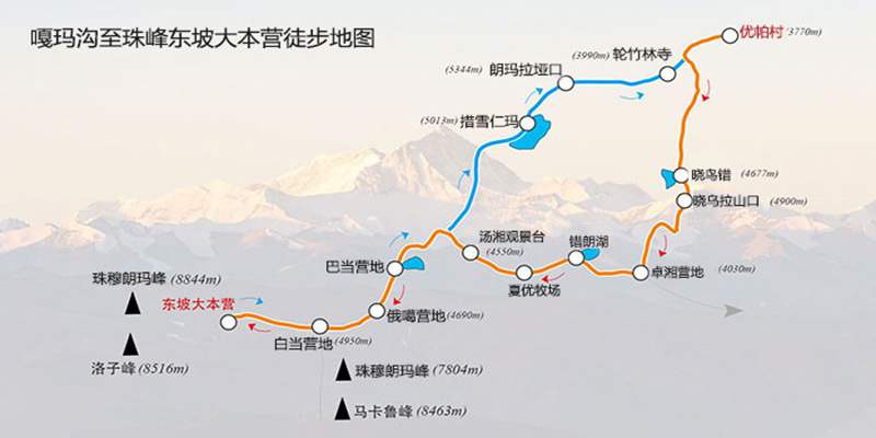
The Everest East Face and Gama Valley Trail
Best Time to Hike
The ideal periods are April to May and September to October. During these months, the weather is clear with excellent visibility, minimal rain and snow, making it perfect for mountain viewing. In April and May, wildflowers bloom across the grasslands, creating a vibrant contrast against the snow-capped peaks. In September and October, the dry air makes the night sky exceptionally clear, offering stunning views of the Milky Way.
Difficulty Level
Moderate to challenging. The highest elevation is around 5,300 meters, slightly lower than Mount Kailash, but the longer duration of the hike (7 to 8 consecutive days) places greater demands on physical endurance. Hikers should have some prior experience and be well-prepared for altitude sickness.
Key Highlights
The biggest draw is the unique opportunity to see four 8,000-meter peaks simultaneously—a rare experience anywhere in the world. Standing in the valley, you will gaze up at these majestic mountains piercing the clouds, a sight that will leave you speechless. The valley’s pristine ecosystem supports diverse wildlife, including Tibetan antelopes and wild donkeys, which you may spot grazing on the grasslands. At night, the brilliant starry sky is unforgettable; lying in your tent and watching the Milky Way stretch across the heavens will wash away all your fatigue.
Itinerary Suggestion
We recommend an 8-day itinerary at a relaxed pace to fully enjoy the scenery and acclimate to the altitude. Day 1: Drive from Qudang Township to Youpa Village, then hike to Xiaowu Tso to admire the alpine lake. Day 2: Cross Xiaowu La Pass and hike to Zhuoxiang. Day 3: Hike to Tangxiang, an excellent viewpoint for Mount Everest and Lhotse. Day 4: Hike to Ega for close-up views of the snow-capped peaks. Day 5: Hike to Baidang, where you can see the full profile of Mount Everest and its glaciers. Day 6: Return to Tangxiang to revisit the stunning mountain views. Day 7: Hike to Cuoxuerenma, home to multiple alpine lakes with perfect mountain reflections. Day 8: Cross Langma La Pass and return to Qudang Township to conclude your hike.
Kula Kangri Hiking: A Classic Beginner-Friendly Route
If you are new to hiking in Tibet and wondering which route to choose, Kula Kangri is the perfect starting point. It offers a manageable difficulty level and gentle terrain, making it accessible to hikers with basic physical fitness and no extensive outdoor experience. Best of all, it combines stunning views of snow-capped mountains, lakes and grasslands, allowing beginners to experience the joy of hiking while immersing themselves in Tibet’s natural beauty.
Route Overview
The entire trail is approximately 50 kilometers long and takes 5 to 6 days to complete. It starts and ends in Se Township, with relatively flat terrain and minimal elevation gain, making it easy for beginners to adjust to the altitude at a comfortable pace.
Best Time to Hike
The best periods are April to June and September to November. During these months, the weather is stable with little rain or snow, the lakes are crystal clear, and the snow-capped peaks are visible. In April to June, wildflowers carpet the grasslands, creating beautiful reflections in the lakes. In September to November, the dry air ensures excellent visibility, and there are fewer tourists, allowing you to enjoy the hike in peace.
Difficulty Level
Beginner-friendly. The highest elevation is around 5,200 meters, and most of the trail consists of gentle mountain paths with no steep sections. Even hikers with no outdoor experience can complete this route successfully with proper altitude acclimatization and preparation.
Key Highlights
The trail’s biggest attraction is its stunning alpine lakes: Baima Lin Tso, Jiejiu Tso and Zhegong Tso, each with its own unique charm. Baima Lin Tso, considered the soul lake of Guru Rinpoche, changes color with the light, shifting from deep blue to emerald green—a magical phenomenon. You will also get up close to glaciers and enjoy perfect reflections of snow-capped mountains in the lakes. Walking across the vast grasslands, you will experience the tranquility and purity of Tibet, making it an ideal introduction to Tibetan hiking.
Itinerary Suggestion
Beginners should take the 6-day itinerary to pace themselves and fully appreciate the scenery. Day 1: Drive from Lhasa to Se Township and rest overnight to acclimate to the altitude. Day 2: Hike to Baima Lin Tso to enjoy the lake and mountain views. Day 3: Hike around Baima Lin Tso to see its full beauty, then continue to Jiejiu Tso. Day 4: Hike to Zhegong Tso, where you can see more primitive scenery, glaciers and snow-capped peaks. Day 5: Return to Se Township, revisiting your favorite spots along the way. Day 6: Drive back to Lhasa to end your pleasant hiking journey.
Shishapangma Hiking: A Feast of Snow-Capped Peaks and Lakes
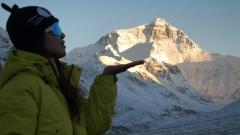
As the only 8,000-meter peak entirely within China’s borders, Mount Shishapangma offers one of Tibet’s most rewarding hiking experiences. The trail centers on the mountain and connects numerous alpine lakes, creating a visual feast of snow-capped peaks and tranquil waters. With the majestic Shishapangma as your backdrop and the brilliant blue waters of Peiku Tso and other lakes, every moment is a photo opportunity, making this a must-visit for photographers and mountain lovers alike.
Route Overview
The trail spans approximately 100 kilometers and takes 8 to 9 days to complete. It starts in Nyalam County and ends at Peiku Tso, passing through multiple campsites along the way. While the terrain is relatively gentle, the long distance places significant demands on physical stamina and endurance.
Best Time to Hike
The optimal periods are April to May and September to October. During these months, the weather is clear with excellent visibility, minimal precipitation, and perfect conditions for viewing mountains and lakes. September to October is particularly ideal, as the dry air makes the mountain outlines sharp and the lake waters exceptionally blue. The grasslands remain green, adding to the scenic beauty.
Difficulty Level
Moderate to challenging. The highest elevation is around 5,600 meters, similar to Mount Kailash. Hikers need prior experience and good altitude acclimatization. The 8 to 9 consecutive days of hiking also require strong physical endurance, so this route is not recommended for beginners.
Key Highlights
The main attraction is the chance to admire Mount Shishapangma from all angles, with particularly stunning views at sunrise and sunset when the peak glows golden. The trail passes through numerous alpine lakes, including Peiku Tso—the largest lake in Shigatse Prefecture. Its deep blue waters contrast beautifully with the snow-capped mountains, and the surrounding grasslands with grazing yaks and sheep create a picturesque Tibetan landscape. You may also spot rare wildlife such as Tibetan wild donkeys and antelopes, showcasing Tibet’s rich natural ecosystem.
Itinerary Suggestion
We recommend a 9-day itinerary to distribute your energy evenly and ensure safety while enjoying the scenery. Day 1: Drive from Lhasa to Shigatse and rest overnight to acclimate. Day 2: Drive to Nyalam County and prepare for the hike. Day 3: Hike to Yiga Camp to experience the alpine meadows. Day 4: Hike to Xinde Camp, where you will first catch sight of Mount Shishapangma. Day 5: Hike to the South Base Camp for close-up views of the mountain’s glaciers. Day 6: Hike to Gong Tso Camp to admire the beautiful Gong Tso lake. Day 7: Hike to the south bank of Peiku Tso to experience its grandeur. Day 8: Drive back to Shigatse and rest overnight. Day 9: Return to Lhasa to conclude your mountain and lake adventure.
Nyainqentanglha East Hiking: Hidden Gem with Breathtaking Scenery
If you prefer off-the-beaten-path destinations and want to avoid crowds, the Nyainqentanglha East trail is the perfect choice. Located in the eastern part of the Nyainqentanglha Mountains, it remains largely undeveloped, preserving its pristine natural beauty. With few visitors, you will have the mountains, glaciers and lakes all to yourself, making it ideal for experienced hikers seeking solitude and a true wilderness challenge.
Route Overview
At approximately 120 kilometers, this is the longest trail on our list and takes 10 to 12 days to complete. It starts in Biru County and ends in Jiali County, with complex terrain including mountain paths, grasslands and glacial sections, placing high demands on hikers.
Best Time to Hike
The best period is June to September, when wildflowers bloom across the grasslands in a riot of colors. The weather is relatively stable with minimal snowfall, and road conditions are better, allowing you to fully enjoy the stunning scenery.
Difficulty Level
Difficult. The highest elevation is around 5,400 meters, and the trail features many steep mountain paths and glacial sections. Hikers need extensive experience, professional equipment and excellent physical stamina. We strongly recommend joining a professional hiking team and never attempting this route alone.
Key Highlights
The biggest advantage is its seclusion and pristine nature. With almost no other tourists, you can enjoy the breathtaking scenery in complete peace, surrounded only by snow-capped mountains, glaciers, lakes and grasslands. The trail passes dozens of unclimbed peaks that retain their original, untouched beauty, as well as numerous crystal-clear alpine lakes with perfect mountain reflections. The excellent ecosystem supports a wide variety of rare wildlife, offering a true taste of Tibet’s natural wilderness.
Itinerary Suggestion
This route is not suitable for beginners and is only recommended for experienced hikers. Always travel with a professional team that provides experienced guides and proper equipment to ensure your safety. The 10 to 12-day itinerary is designed to allow you to hike at a relaxed pace and fully appreciate the primitive beauty of this hidden gem. Always follow your team’s instructions and never leave the group without permission.
General Tips for Hiking in Tibet
Now that you know the best hiking trails in Tibet, here are some essential tips to ensure a safe, enjoyable and memorable experience, regardless of which route you choose.
Altitude Sickness Prevention
Tibet has an average altitude of over 4,000 meters, and altitude sickness is a common concern for hikers. Start taking Rhodiola supplements one week before your trip. Upon arrival, avoid strenuous exercise, drink plenty of water and get plenty of rest. Do not take a shower immediately after arriving. If you experience severe symptoms such as headache, vomiting or difficulty breathing, descend to a lower altitude immediately and seek medical help.
Equipment Preparation
Tibet’s weather is unpredictable, with large temperature differences between day and night. Pack warm clothing including a waterproof jacket, down jacket and fleece layer. Choose waterproof, non-slip hiking shoes and use trekking poles and knee pads to reduce strain on your legs. High-factor sunscreen, sunglasses and a hat are essential to protect against the strong UV rays. A headlamp is also necessary for any night walking.
Environmental Protection and Local Customs
Tibet’s ecosystem is fragile, so do not litter. Carry all your waste with you and dispose of it properly outside the mountains. Respect local religious beliefs and customs. Do not take photos of pilgrims or religious sites without permission. When visiting monasteries, follow the rules, speak quietly and do not touch religious artifacts.
Safety Assurance
Never leave your group while hiking. For remote or difficult routes, always join a professional team. Avoid hiking during heavy rain, snow or other severe weather conditions. Purchase comprehensive outdoor insurance before your trip. In case of emergency, call 110, 120 or contact local rescue services immediately.
Choose Your Ultimate Tibet Trekking Adventure
The best trekking routes in Tibet offer far more than breathtaking landscapes—they provide transformative journeys through some of the most remote and spiritually significant regions on Earth. Whether you seek the sacred devotion of Mount Kailash, the dramatic beauty of the Everest East Face, or the untouched wilderness of Nyenchen Tanglha East, each trail promises an unforgettable experience tailored to different skill levels and aspirations.
For a seamless and safe trekking experience, expert planning is essential. China Dragon Travel specializes in customized Tibet trekking tours, offering experienced local guides, reliable logistics, and comprehensive travel support. With professional assistance, you can explore Tibet’s most iconic trails with confidence and turn your Himalayan adventure into a once-in-a-lifetime achievement.