The Tianshan Mountains are an important mountain range in Asia, renowned for their magnificent snow-capped peaks, vast grasslands, and clear alpine lakes. When people plan to travel to the Tianshan area, the first basic question they need to clarify is: “Where is Xinjiang Tianshan?” This is not only about geographical location but also directly affects the planning of travel routes. This article will systematically introduce the geographical location, main components, and landscape differences between the northern and southern slopes of the Tianshan Mountains, and provide specific transportation information and travel suggestions to help you fully understand Tianshan and effectively arrange your itinerary.
Where in Asia is the Tianshan Mountains in Xinjiang?
To accurately understand where Xinjiang Tianshan is, it is first necessary to recognize this mountain range on a macro scale. The Tianshan Mountains are one of the most important mountain systems in Central Asia, stretching east-west for more than 2,500 kilometers, making it a typical transnational mountain range. Its main part is located in the Xinjiang Uygur Autonomous Region of China, usually referred to as Xinjiang Tianshan; the western section of the mountain range extends to Central Asian countries such as Kazakhstan and Kyrgyzstan.
On China’s territory, the location of Xinjiang Tianshan has clear geographical significance. It roughly runs through the central part of Xinjiang, becoming an important physical geographical dividing line. To the south of the mountain range is the Tarim Basin (often called Southern Xinjiang), and to the north is the Junggar Basin (Northern Xinjiang). This mountain range not only divides Xinjiang into northern and southern parts geographically but also has a decisive impact on climate, hydrology, and vegetation distribution. Therefore, geographically speaking, Xinjiang Tianshan refers to the main part of the mountain range located in Xinjiang, China, stretching about 1,700 kilometers east-west.
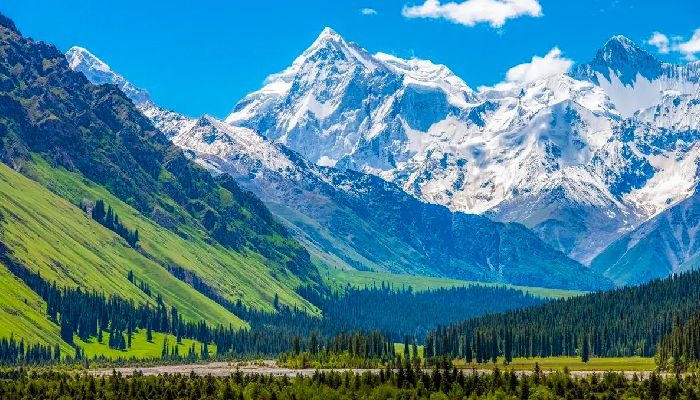
Main Peak Landscape of the Tianshan Mountains
What Regions Does Xinjiang Tianshan Cover?
After clarifying the overall location, further understanding the internal regional division of Tianshan can better answer the question “Where are the specific landscapes of Xinjiang Tianshan?” The Tianshan Mountains are not a single mountain ridge but consist of several parallel mountain ranges, as well as intermontane basins and river valleys between them. According to geographical characteristics and landscape distribution, it can be divided into the following main regions:
- Eastern Tianshan Region: Mainly refers to the section of Tianshan north of Hami and Turpan. This region has relatively open mountain terrain, including characteristic attractions such as Barkol Grassland and Tianshan Temple. Mount Bogda, with an altitude of 5,445 meters, is the iconic peak of Eastern Tianshan, and its snow-capped peak can be seen from downtown Urumqi on clear days.
- Central Tianshan Region: This is the core area with the most concentrated landscapes and the most convenient access in Tianshan, surrounding Urumqi City and Changji Hui Autonomous Prefecture. The famous Heavenly Lake (ancient Yaochi) is located on the northern slope of Mount Bogda. With convenient transportation, this region is the first choice for most first-time visitors.
- Western Tianshan Region: This is the highest-altitude area of the Tianshan Mountains with the most fully developed modern glaciers, mainly located in Ili Kazakh Autonomous Prefecture and Bayingolin Mongol Autonomous Prefecture. Its highest peak is Mount Tomur, with an altitude of 7,443 meters. Western Tianshan is world-famous for its vast and beautiful alpine grasslands, such as Kalajun Grassland, Nalati Grassland, Bayanbulak Grassland, and the historically and culturally significant Xiaata Ancient Road.
- Southern Tianshan Region: Located on the northern edge of the Tarim Basin, covering parts of Aksu Prefecture and Kizilsu Kirghiz Autonomous Prefecture. The mountains here are steep, forming a strong contrast with the desert landscapes on the edge of the basin, resulting in unique geological landscapes such as Wensu Grand Canyon and Kuqa Grand Canyon (Tianshan Mysterious Grand Canyon).
Understanding the above divisions helps travelers quickly locate the approximate positions of target attractions in Xinjiang Tianshan based on their interests and time.
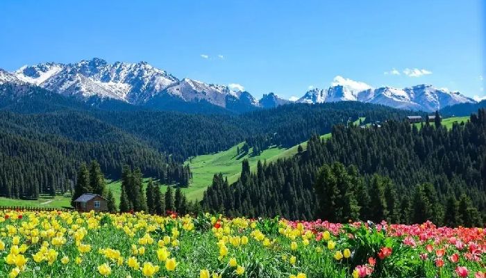
Alpine Grasslands and Forests of Tianshan
What Are the Differences Between the Northern and Southern Slopes of Tianshan?
The huge mountain body of the Tianshan Mountains blocks water vapor, resulting in distinct natural landscapes on its north and south wings (i.e., the northern slope and the southern slope). This difference is a key factor to consider when planning a trip.
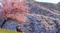
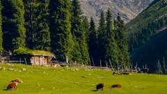
- Northern Slope Landscape Characteristics: Facing the Junggar Basin, the northern slope of Tianshan can receive a small amount of moist air from the north, with relatively more precipitation. Therefore, the northern slope has developed a complete vertical zonal spectrum, with glaciers, alpine meadows, spruce forests, grasslands, and river valley woodlands commonly seen from top to bottom. The landscape is characterized by humidity and lush greenery, with representative attractions including Heavenly Lake, Nalati Grassland, and Jiangbulak. The travel experience on the northern slope is usually more comfortable, with dense vegetation and abundant water sources.
- Southern Slope Landscape Characteristics: Backed by the extremely arid Tarim Basin, the southern slope of Tianshan has scarce precipitation and a dry climate. Its landscape is dominated by arid desert mountains, with sparse vegetation, and exposed rock mountains, deep dry-hot canyons, and desert Gobi are common. Kuqa Grand Canyon and Wensu Grand Canyon are typical representatives of the southern slope landscape, presenting a visually shocking scene of desolation, grandeur, and colorful colors. Travelers in this region need to be prepared for wind and sand, sun protection, and coping with the dry climate.
Choosing to visit the northern or southern slope of Tianshan mainly depends on personal preference for natural landscape types: whether you prefer the beauty of forests and grasslands or the vastness of canyons and deserts.
How to Get to and Tour Tianshan?
After clarifying “Where is Xinjiang Tianshan” and the distribution of its internal landscapes, the next step is to plan specific transportation and tour plans. The following are practical suggestions based on geographical locations.
Main Transportation Hub Cities
- Urumqi City: As the capital and largest aviation hub of Xinjiang, it is the most convenient gateway to the northern slope and central Tianshan region. The downtown area is about 1.5 hours’ drive from the Heavenly Lake Scenic Area.
- Yining City: Located in the Ili River Valley, it is the best starting point for exploring the grassland scenery of western Tianshan (such as Nalati, Kalajun, and Zhaosu).
- Korla City / Kuqa City: These two cities are located at the southern foot of Tianshan and are the main service bases for traveling to the southern Tianshan canyon area (Kuqa Grand Canyon, Wensu Grand Canyon) and Bayanbulak Grassland.
- Aksu City: It is an important transportation node for traveling to the Mount Tomur area and Wensu Grand Canyon.
Main Tour Methods
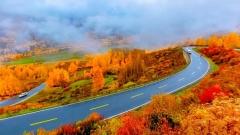
- Road Trip and Crossing: Driving through Tianshan is an excellent way to experience its magnificent landforms. The Duku Highway (from Dushanzi to Kuqa) runs north-south through Tianshan, known as the “Landscape Avenue,” where you can enjoy the drastic changes from forest grasslands to canyon deserts along the way. Yizhao Highway and Saiguo Expressway are also scenic mountain highways. This method is suitable for travelers with sufficient time and a pursuit of in-depth experience.
- Key Scenic Area Tour: For travelers with limited time, you can choose 1-2 core scenic areas for in-depth tours. For example, tour Heavenly Lake centered on Urumqi; or tour Nalati and Kalajun Grasslands centered on Yining. Each major scenic area has complete viewing plank roads and transportation connection facilities.
- Hiking and Professional Exploration: The Tianshan mountain area has many classic hiking routes, such as the Xiaata Ancient Road and the Mount Bogda Grand Loop. Such activities have high requirements for participants’ physical fitness, equipment, and experience. They must be led by professional guides, and adequate logistics and safety preparations must be made.
Itinerary Planning Suggestion: Due to the vast area of Tianshan, scattered attractions, and clear seasonal opening periods for some roads (such as Duku Highway, usually from June to early October), it may be cumbersome to plan all transportation, accommodation, and tickets by yourself. Entrusting a travel agency with local operation experience, such as China Dragon Travel, to assist in arranging the itinerary, vehicles, and ticket bookings can effectively improve travel efficiency and reliability, allowing travelers to focus more on the landscape experience.
Practical Pre-Travel Preparation Points
A successful trip is inseparable from careful pre-travel preparation. Based on the geographical and climatic characteristics of Tianshan, the following suggestions are particularly important to ensure a smooth and safe trip:
- Travel Season Selection: The best travel season for most scenic areas in Tianshan is summer and early autumn (June to September). At this time, the climate is mild, the grasslands are lush, and the road conditions in the mountainous areas are good. In winter (November to March of the following year), there is heavy snowfall in the mountainous areas, and many roads and scenic areas will be closed. In spring (April to May), you may encounter snowmelt floods or slippery roads. Be sure to check the latest opening announcements of the target roads and scenic areas before traveling.
- Coping with Altitude and Climate: Many scenic areas in Tianshan are above 2,000 meters to 3,000 meters above sea level. When first arriving at the plateau, avoid strenuous exercise, rest well, and prevent altitude sickness. The weather in the mountainous areas is changeable, with large temperature differences between day and night. Even in summer, you need to prepare warm and windproof clothing (such as fleece jackets, waterproof jackets, or thin down jackets), sunscreen, sunglasses, and hats.
- Transportation and Accommodation Booking: During the peak tourist season (July to August and National Day holiday), tickets, accommodation in popular scenic areas along Tianshan, and parking resources along the Duku Highway may be very tight. It is strongly recommended to book through formal channels in advance. Especially for tourists planning to drive through the Duku Highway, they need to understand the road conditions and traffic restriction information in advance and plan the daily stop points.
- Documents and Safety: To travel to border areas (such as near Kanas) or some special areas, you may need to apply for a border pass. During the trip, please abide by the safety regulations of the scenic areas and do not enter undeveloped areas without permission. It is recommended to purchase travel insurance covering plateau travel and emergency medical evacuation.
Xinjiang Tianshan Itinerary Planning Suggestions
In summary, to answer “Where is Xinjiang Tianshan,” it is necessary to understand it from multiple geographical dimensions. It is a huge mountain range spanning China and Central Asia. Its part located in Xinjiang stretches about 1,700 kilometers east-west and can be further divided into four main regions (eastern, central, western, and southern) according to landscape characteristics. Due to climate differences, the northern and southern slopes have formed two distinct landscape styles: forest grasslands and arid canyons.
For travelers planning to visit, clarifying the type of landscape you are interested in (whether it is grasslands and lakes or canyon landforms) is the first step in choosing a specific destination. Then, according to the selected destination, determine the corresponding gateway city (such as Urumqi, Yining, Kuqa), and choose a suitable tour method such as self-driving crossing, key scenic area tour, or professional hiking. Fully considering the travel season, preparing for altitude adaptation, equipping with appropriate clothing, and making advance reservations for key items are the keys to ensuring a smooth, safe, and pleasant journey.
Tianshan has extremely rich and diverse natural landscapes, which are worth exploring in depth. When planning complex long-distance trips or traveling to remote areas, consulting and relying on the local experience and resources of professional institutions such as China Dragon Travel can obtain more efficient and reliable itinerary plans and logistics support, allowing you to appreciate the grandeur and color of the Tianshan Mountains more calmly and in-depth.