This article features the full map of Yunnan and regional maps of Yunnan’s key cities (including Kunming, Dali, Lijiang, etc.). It provides detailed insights into recommended attractions, high-speed rail transportation, and practical tips to help you plan your ideal Yunnan itinerary. Whether you want to experience the classic Kunming-Dali-Lijiang route, immerse yourself in Xishuangbanna’s tropical charm, or explore Shangri-La’s plateau secrets, this map-guided attraction analysis will help you arrange a seamless trip to enjoy Yunnan’s natural beauty and cultural heritage. We’ve also compiled a list of local specialty food spots and budget-friendly accommodation options, ensuring a worry-free, enjoyable journey with hassle-free food, lodging, transportation, and sightseeing.
Yunnan Travel Guide: Explore the Colorful Borderland Starting from the Map
Yunnan is a treasure trove of diverse landscapes and cultures in southwest China, boasting karst stone forests, snow-capped mountains and canyons, millennia-old towns, and tropical rainforests all within its borders. The full map of Yunnan clearly outlines the province’s travel geography: central Yunnan radiates from Kunming, northwest Yunnan features a scenic route linking Dali, Lijiang, and Shangri-La, and southern Yunnan offers a tropical cultural and commercial route centered on Xishuangbanna. Combined with regional travel maps, this guide breaks down must-visit attractions, transportation routes, and practical tips to help you plan an efficient and enriching Yunnan adventure.
The Map of Yunnan Province: Understanding the Geographic Layout of Colorful Yunnan
Located in the southwestern border area of China, Yunnan Province boasts remarkable geographical advantages. It borders Guizhou and Guangxi in the east, Sichuan in the north, and Tibet in the northwest, while its western and southern boundaries adjoin three countries: Myanmar, Laos, and Vietnam. It ranks among the Chinese provinces with the longest land border lines.
A glance at the complete map of Yunnan reveals that the province is dominated by plateaus and mountains. The Hengduan Mountains, stretching vertically from north to south, not only give rise to the unique climate characterized by the saying “One mountain embraces four seasons, and every ten li presents a different sky” but also nurture an extremely rich diversity of natural and cultural landscapes. Within the map’s latitude and longitude coordinates, visitors can find both the majestic snow-capped mountains and deep canyons in the north and the lush tropical rainforests in the south; there are time-honored ancient towns and streets carrying thousands of years of history, as well as ethnic minority villages preserving their original lifestyles and customs.
Using the map as a planning reference, Yunnan’s tourism resources can be clearly divided into three core sectors:
- Northwest Yunnan Snow Mountain & Ancient Town Route: Centered on Lijiang, Dali, and Shangri-La, it features plateau snow-capped mountains and the unique charm of humanistic ancient towns.
- Southern Yunnan Tropical Scenery & Cultural Route: With Xishuangbanna as the hub, it showcases tropical landscapes and the diverse cultures of various ethnic groups.
- Central Yunnan Provincial Capital Cultural Route: Focusing on Kunming, the provincial capital, it highlights urban leisure activities and the distinctive cultural traits of central Yunnan.
Whether traveling by self-driving, public transportation, or group tours, the complete map of Yunnan serves as an essential tool for planning travel routes. It not only clearly marks the precise locations of cities and transportation hubs but also implies the travel logic of “where to start, where to go, and what to see along the way”, providing clear guidance for tourists embarking on their Yunnan journey.
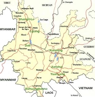
Yunnan map
Yunnan & Surrounding Cities Maps: Core Guides for Regional Exploration
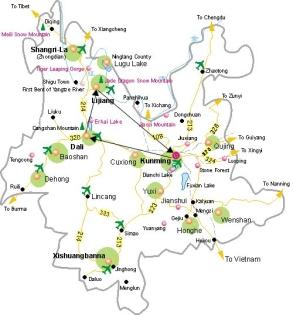
Yunnan Tourism Map: A Network Linking Attractions Across the Province
The Yunnan tourism map integrates the province’s top attractions into well-defined routes:
The classic Kunming-Dali-Lijiang (KDL) Route covers Yunnan’s most iconic destinations.
The Northwest Yunnan In-depth Route extends to Shangri-La and Meili Snow Mountain.
The Southern Yunnan Scenic Route connects Xishuangbanna, Pu’er, and other regions.
Using this map, travelers can flexibly combine routes based on their time and preferences—for example, a 5–7 day trip along the KDL Route, or a 10+ day in-depth tour covering both northwest and southern Yunnan.
Kunming Tourism Map: Year-Round Leisure in the “City of Eternal Spring”
As the capital of Yunnan Province, Kunming is the first stop for most tourists entering Yunnan. Below are the core recommended attractions on Kunming’s tourist map, covering natural wonders and cultural customs, to facilitate itinerary planning:
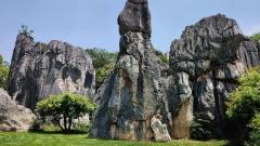
Stone Forest Scenic Area
A World Natural Heritage Site, featuring the spectacular Stone Forest formed by karst landforms. The stone peaks stand densely like a forest, presenting a fantastic scenery. Approximately 80 kilometers from Kunming’s urban area, and a filming location for “Journey to the West”.
Dianchi Lake
The largest freshwater lake in Yunnan, boasting beautiful lake and mountain scenery, and serving as an ideal resort for leisure and vacation. Clear around-the-lake routes available; black-headed gulls can be observed in winter, and cycling along the lake is suitable in summer; adjacent to Xishan Forest Park, offering a panoramic view of the lake.
Yunnan Ethnic Village
Concentrating the cultures of 26 ethnic minorities in Yunnan, providing one-stop experiences of architectures, customs and performances. Located by Dianchi Lake, it is a window to quickly understand Yunnan’s ethnic cultures.
Golden Horse and Green Rooster Archways
A landmark of Kunming’s old town, featuring ancient-style architectural complexes with strong traditional charm and a lively atmosphere. Located in the old town area, surrounded by food streets and characteristic shops; more charming when the lights are on at night.
Kunming map
Dali Tourism Map: A Poetic Retreat of “Wind, Flowers, Snow, and Moon”
Located west of Kunming, Dali is a core stop on the KDL Route. Must-visit attractions on the Dali tourism map include:
Dali Ancient Town
West of Kunming, core node of the Kunming-Dali-Lijiang route, core area of Dali. Founded in the Ming Dynasty, landmark attractions include the city wall, Confucian Temple and Foreigner Street; you can wander through ancient alleys and taste milk fan during the day, and listen to folk songs in bars at night.
Erhai Lake
Within Dali, the second largest lake in Yunnan. The around-the-lake route is about 130 kilometers, a favorite among tourists; you can rent an electric bike to tour around the lake, passing through Shuanglang Ancient Town, Wase Town, Xiaoputuo and other attractions; the lake shimmers under the sunset, which is the “Erhai Moon” in the “Wind, Flower, Snow and Moon”.
Chongsheng Temple Three Pagodas
About 1.5 kilometers away from Dali Ancient Town. A royal temple during the Dali Kingdom period, the landscape of the three towering pagodas is one of the symbols of Dali; you can visit the Buddhist cultural relics exhibition in the temple.
Cangshan Mountain
Opposite Erhai Lake. There are many hiking routes marked on the tourist map; you can take a cable car to Ximatan (Horse Washing Pond), enjoying the sea of clouds and azaleas along the way; you can experience hiking at Ximatan on Cangshan Mountain in summer.
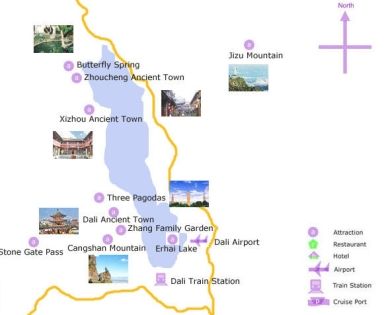
Dali map
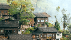
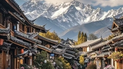
Lijiang Map: Where Ancient Towns Meet Snow-Capped Mountains
Located north of Dali, Lijiang is a highlight of northwest Yunnan’s tourism. Core attractions on the Lijiang map include:
Lijiang Ancient City: A UNESCO World Heritage Site also known as Dayan Ancient Town, centered around Sifang Street. Its features include bluestone streets and alleys crisscrossed by flowing streams. The ancient city comes alive at night with twinkling lights, perfect for strolling or experiencing Naxi ethnic culture.
Jade Dragon Snow Mountain: Approximately 15 kilometers from Lijiang Ancient City, it is the southernmost snow-capped mountain range in the Northern Hemisphere. The Lijiang map marks cable car routes and sightseeing paths—travelers can take the Grand Cableway to Glacier Park (4,680 meters above sea level), or visit Blue Moon Valley (known as “Little Jiuzhaigou”) and Spruce Meadow.
Shuhe Ancient Town: Quieter than Lijiang Ancient City, it preserves more of the original Naxi ethnic architecture and customs. Sifang Street and stone arch bridges in the town exude old-world charm, ideal for a slow-paced visit.
Tiger Leaping Gorge: Located between Lijiang and Shangri-La, it is one of the deepest canyons in the world. Upper Tiger Leaping Gorge, marked on the Lijiang map, is the most popular section for visitors, offering a close-up view of the roaring Jinsha River rushing through the gorge.
Lijiang map
Xishuangbanna Map: Tropical Rainforest Charm
Located in southern Yunnan, bordering Laos and Myanmar, Xishuangbanna’s recommended attractions on its map include:
Xishuangbanna Tropical Botanical Garden, Chinese Academy of Sciences: China’s largest tropical botanical garden, divided into East and West Zones. The West Zone is the main sightseeing area, home to rare plants such as giant water lilies (Victoria amazonica) and sky trees (Parashorea chinensis). The East Zone is a primeval rainforest, suitable for hiking and exploration.
Wild Elephant Valley: The only place in China where visitors can observe Asian elephants up close. The Xishuangbanna map marks areas such as the Elephant School and the Canopy Walkway, where you can participate in elephant feeding and watch elephant performances.
Man Ting Park: Once the imperial garden of the Dai kings, it features Dai-style architecture and tropical plants. The park hosts evening activities like campfire parties and water lantern releasing, which are deeply rooted in Dai ethnic traditions.
Gaozhuang Xishuangjing: An emerging commercial and cultural district in Xishuangbanna, with the Great Golden Pagoda as its landmark. The Starlight Night Market at night is a must-visit—you can taste Dai snacks, buy handicrafts, and take photos in traditional Dai costumes.
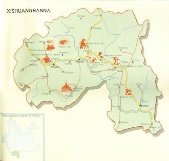
Xishuangbanna map
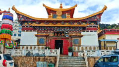
Shangri-La Map: The Sun and Moon in Your Heart
Located at the northwestern tip of Yunnan, Shangri-La is one of the final stops on the northwest Yunnan route. Must-visit attractions on the Shangri-La map include:
Pudacuo National Park: China’s first national park, encompassing Shudu Lake, Bitahai Lake, and Xiagei Village. The Shangri-La map marks sightseeing bus routes—spring brings blooming rhododendrons, summer showcases flower-carpeted meadows, and autumn paints the forests in vibrant red and gold hues.
Dukezong Ancient Town: Once a major trade hub in the Tibetan region, the town’s Guishan Park houses the world’s largest prayer wheel. Visitors can join in the traditional practice of spinning the wheel for blessings. At night, the ancient town’s lights complement its Tibetan-style architecture, creating a magical atmosphere.
Songzanlin Monastery: Known as the “Little Potala Palace”, it is Yunnan’s largest Tibetan Buddhist monastery. With its grand architecture, visitors can explore the temple halls and learn about Tibetan Buddhist culture. The Ramyang Co Lake outside the monastery offers stunning reflections of the monastery against the mountain backdrop.
Napa Lake Yila Grassland: A unique combination of plateau wetland and grassland. The Shangri-La map highlights its seasonal transformations—summer turns it into a lush grassland, while winter floods it into a lake. Horse riding here allows you to enjoy the scenic views of grasslands and distant mountains.
Yunnan High-Speed Rail Transportation: A Hub Connecting Cities Efficiently
With the improvement of the high-speed rail network, Yunnan’s high-speed rail has become a vital transportation option for travelers moving between cities. As shown on the full map of Yunnan Province, the currently operating high-speed rail lines include:
Kunming-Chuxiong-Dali High-Speed Railway: Connecting Kunming, Chuxiong, and Dali in approximately 2 hours, it is a key transportation link for the KDL route, significantly reducing travel time between Kunming and Dali.
Dali-Ruili Railway (Dali-Lijiang Section): Linking Dali and Lijiang in about 1.5 hours, it solves the previous inconvenience of only having bus services between the two cities.
Kunming South Railway Station: The hub of Yunnan’s high-speed rail network, with direct connections to major cities outside the province such as Guiyang, Chengdu, and Chongqing, as well as transfer options to high-speed rail lines within Yunnan.
Travel Tips for Tourist
Climate & Clothing: Yunnan experiences large temperature differences between day and night, especially in northwest Yunnan (Lijiang, Shangri-La). Even in summer, it is advisable to carry a jacket. Xishuangbanna has a tropical climate, so remember to bring sun protection and mosquito repellent.
Altitude Sickness Prevention: Areas like Shangri-La and Jade Dragon Snow Mountain have high elevations. It is recommended to avoid strenuous exercise upon arrival, and you may carry anti-altitude sickness medications such as Rhodiola rosea.
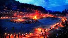
Ethnic Customs Respect: Yunnan is home to many ethnic minorities. When traveling, please respect local customs (e.g., the Naxi Dongba culture, the Dai Water-Splashing Festival traditions).
Transportation Notes: Some attractions in northwest Yunnan (e.g., Tiger Leaping Gorge, Pudacuo National Park) require local buses or chartered cars—plan your transportation in advance. Attractions in Xishuangbanna are relatively scattered; renting a car for self-driving or joining local day tours is recommended.