Xinjiang Uygur Autonomous Region, China’s largest province by area, is an enchanting land of sweeping deserts, soaring mountains, and time‑worn Silk Road oases. From Ürümqi’s modern sprawl to Kashgar’s bustling Sunday market, from the subterranean karez irrigation tunnels of Turpan to the emerald forests surrounding Kanas Lake, Xinjiang offers boundless diversity for adventurous travelers. This article dives deep into the “Xinjiang Map” series—covering geography, cities, attractions, transport arteries, and suggested itineraries—before showing how China Dragon Travel can transform these detailed maps into an unforgettable journey.
Xinjiang Location Map: At the Crossroads of Continents
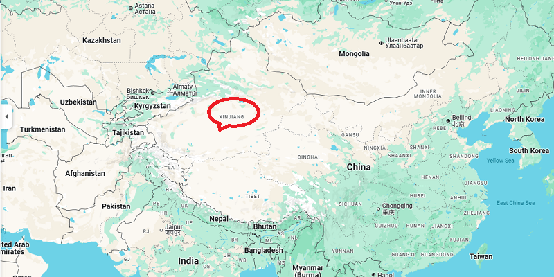
Xinjiang Location Map
Xinjiang sprawls over 1.66 million square kilometers in China’s far northwest, nestled between the Tian Shan and Kunlun ranges. Its strategic position—with eight international borders and connections to Central Asia—has shaped its history and landscape.
Borders and Neighbors
Xinjiang meets Mongolia and Russia to the north; Kazakhstan, Kyrgyzstan, and Tajikistan to the west; Afghanistan and Pakistan to the southwest; and India to the south. Domestically, it adjoins Tibet, Qinghai, Gansu, and Inner Mongolia provinces.
Natural Subregions
- Dzungarian Basin: Grasslands, steppes, and desert margins lie north of the Tian Shan.
- Tarim Basin: Home to the vast Taklamakan Desert, one of Earth’s largest shifting sand seas, in the south.
Silk Road Heritage
For millennia, caravans traversed Xinjiang’s oases, making it a melting pot of cultures, religions, and trade. Today’s modern highways and railways trace many of those ancient routes, linking China to Central Asia and beyond.
Xinjiang Map with Major Cities
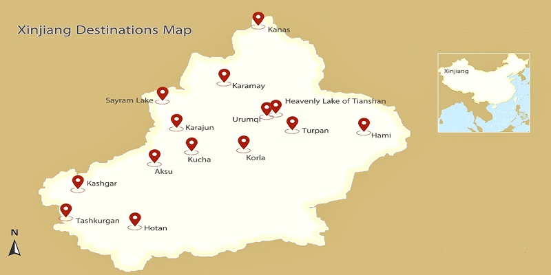
Xinjiang Map with Major Cities
A closer look at the “Xinjiang Map with Cities” reveals urban centers that serve as gateways to the region’s varied landscapes and cultures.
Ürümqi (乌鲁木齐)
Overview: Capital and transport hub of Xinjiang; population ~4 million.
Highlights:
- International Grand Bazaar: A sprawling market offering Uyghur crafts, silk carpets, and local snacks.
- Xinjiang Regional Museum: Renowned for Silk Road artifacts, mummies, and ethnic costumes.
- Red Mountain (Hong Shan): Urban park with panoramic city views.
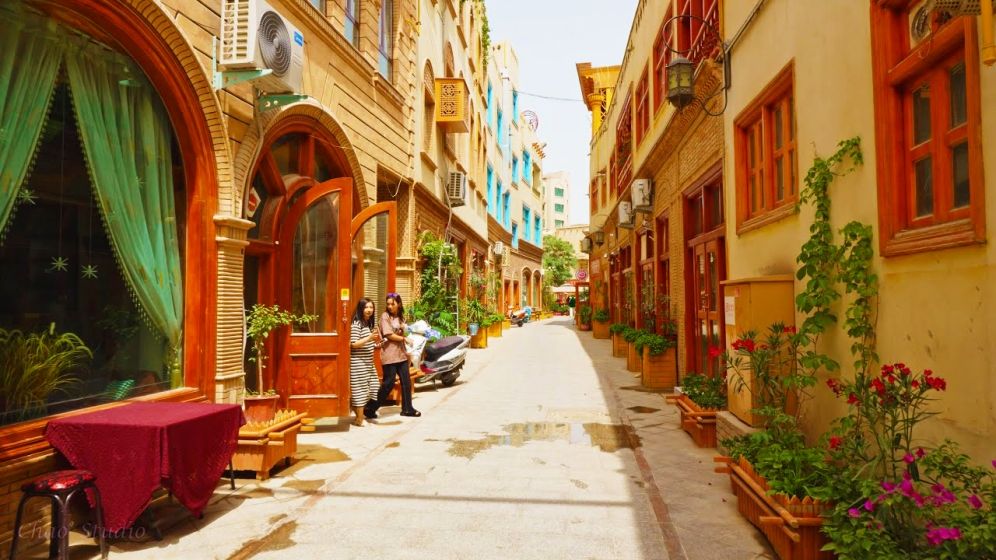
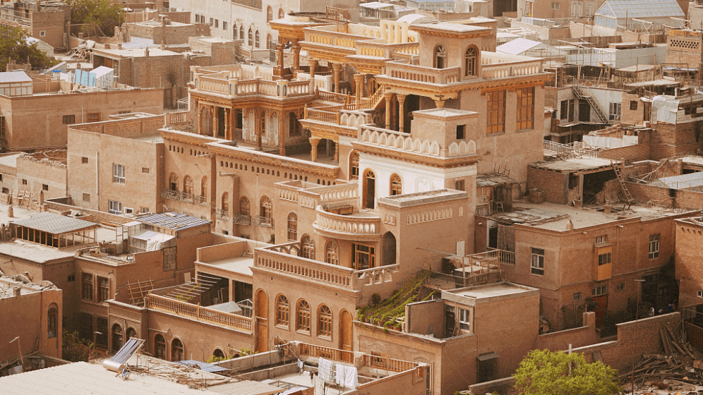
Kashgar (喀什)
Overview: Ancient Silk Road city near the Pamir Plateau.
Highlights:
- Sunday Bazaar: One of Central Asia’s largest outdoor markets, alive with livestock, textiles, and spices.
- Id Kah Mosque: Grandest mosque in western China, reflecting Uyghur architectural styles.
- Old Town: Narrow lanes lined with traditional courtyard homes and teahouses.
Turpan (吐鲁番)
Overview: Oasis city 154 m below sea level; one of the world’s hottest inhabited places.
Highlights:
- Karez System: Ingenious underground channels that sustain vineyards in the arid basin.
- Flaming Mountains: Reddish sandstone cliffs famed in Chinese legend.
- Jiaohe & Gaochang Ruins: Earthen Silk Road capitals carved from the landscape.
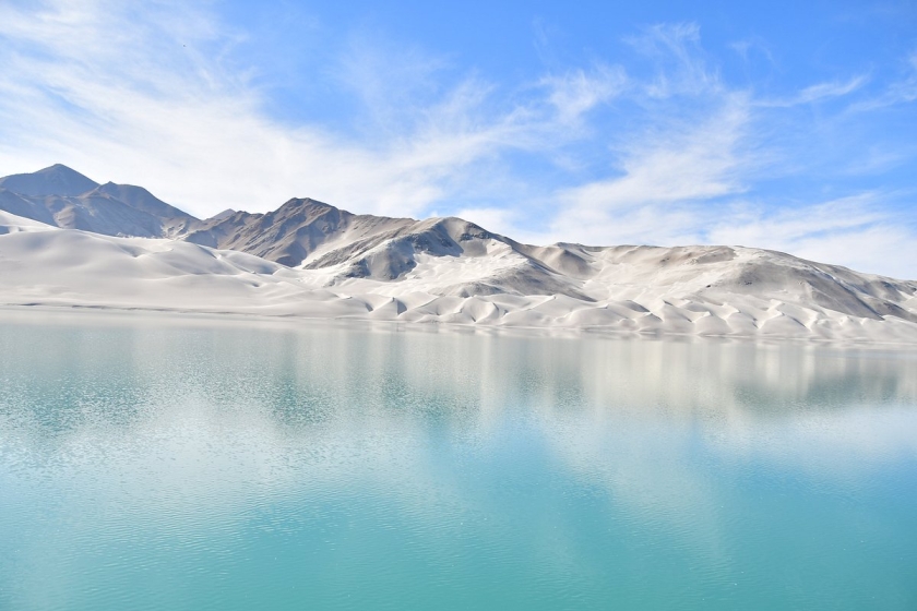
Hotan (和田) & Karakul (喀拉库勒)
Hotan: Center of jade carving and silk weaving; gateway to the southern Silk Road.
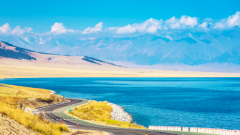
Karakul Lake: High‑altitude gem reflecting Pamir peaks; popular for photography and nomad encounters.
Ili‑Valley Towns: Yining (伊宁), Nalati (那拉提), Sayram Lake (赛里木湖)
Yining: “Little Switzerland” of China, blending Kazakh and Hui cultures.
Nalati Grassland: Sweeping meadows, horseback riding, and yurt stays.
Sayram Lake: Alpine lake with mirror‑like clarity at 2,000 m elevation.
Xinjiang Tourist Map: Must‑See Attractions
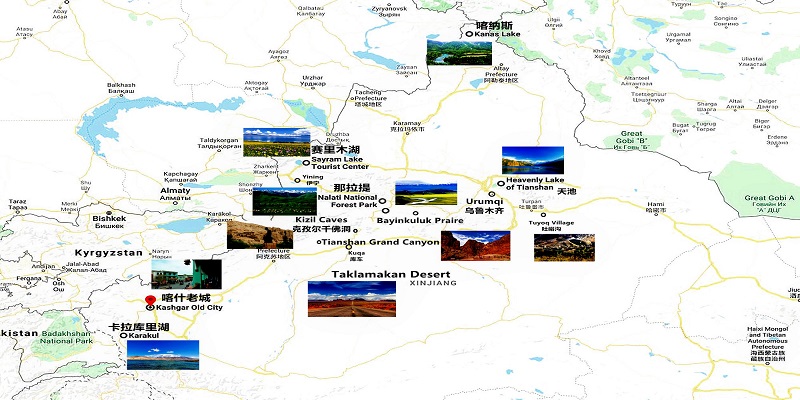
Xinjiang’s attractions span rugged wilderness to ancient ruins. The “Xinjiang Tourist Map” clusters these highlights by region:
Northern Xinjiang
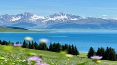
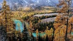
Heavenly Lake (天池): Turquoise alpine lake on the northern slopes of the Tian Shan, ideal for boating and hiking.
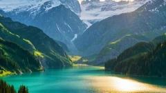
Kanas Lake & Hemu Village: Remote forest‑lined lake and traditional Tuva‑style wooden dwellings.
Five‑Colored Beach (五彩滩): Rainbow‑hued sandstone cliffs along the Irtysh River near Burqin.
Urho Ghost City: Eroded rock spires forming a “stone city” landscape near Karamay.
Keketuohai Geological Park: Striking canyons and multicolored mineral‑rich cliffs.
Eastern Xinjiang
Flaming Mountain: Blazing red sandstone ridges immortalized in classic Chinese literature.
Jiaohe & Gaochang: Millennia‑old urban ruins showcasing ancient defensive architecture.
Dushanzi Grand Canyon: Dramatic gorges and winding river vistas.
Turpan Grapevine Valleys: Lush vineyards bearing award‑winning raisins and fragrant table grapes.
Southern Xinjiang
Taklamakan Desert: Epic dunes for camel treks, starlit campsites, and desert survival experiences.
Kashgar Old Town: Immersive Uyghur cultural district, artisan workshops, and folk music gatherings.
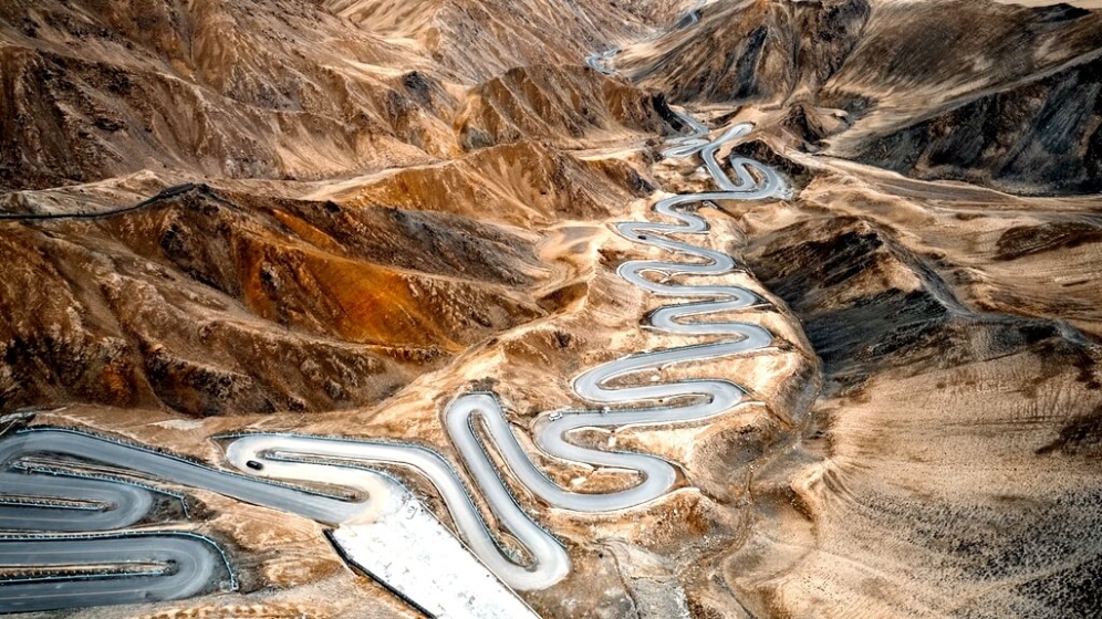
Tashkurgan Stone City: High‑altitude fortress ruins perched at 3,200 m on the Karakoram Highway.
Karakul Lake & Alar Grasslands: Pamir vistas and yurt‑dotted meadows.
Ili‑Valley Attractions
Sayram Lake & Nalati: Cool summers, lush pastures, and traditional Kazakh horseback festivals.
Xinjiang Transportation Map
Efficient logistics are key to exploring Xinjiang’s vast expanse. The “Xinjiang Transportation Map” outlines air, rail, and road networks.
Air Travel
With 25 airports, Xinjiang leads China in domestic air connectivity:
- Ürümqi Diwopu International (URC): Principal international hub.
- Kashgar Laining International (KHG): Southern gateway to Central Asia.
- Turpan Jiaohe (TLQ): Seasonal flights to major Chinese cities.
- Burqin‑Kanas (KJI): Direct access to Kanas Lake.
- Hotan, Korla, Yining, Karamay, Tashkurgan, Xinyuan: Regional feeders linking remote destinations.
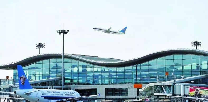
Urumqi Airport
Railways
- High‑Speed Lines: Ürümqi–Lanzhou; Ürümqi–Golmud–Lhasa; upcoming Ürümqi–Kashgar route.
- Conventional Routes: Turpan North (for Lanzhou trains) and Turpan East (slower local services).
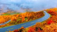
Road Networks
- National Highway 312: Trans‑China artery from Shanghai across Xinjiang to Kashgar.
- G218 & G219: Scenic passes through the Taklamakan and Karakoram Highway borderlands.
- Provincial Roads: Link smaller oases and mountain villages, ideal for self‑drive adventures.
Suggested Xinjiang Itineraries
The “Xinjiang Travel Map” helps craft seamless, thematic journeys:
7‑Day Northern Xinjiang Explorer
| Day | Route & Highlights |
|---|---|
| 1 | Arrive Ürümqi; evening at International Bazaar |
| 2 | Heavenly Lake excursion; overnight Beitun |
| 3 | Drive to Hemu Village; sunset in the woods |
| 4 | Kanas Lake boat tour; Three Bays guesthouse |
| 5 | Five‑Colored Beach; return to Burqin |
| 6 | Urho Ghost City; night in Karamay |
| 7 | Return to Ürümqi; depart |
8‑Day Southern Silk Road Adventure
| Day | Route & Highlights |
|---|---|
| 1 | Ürümqi arrival; Xinjiang Museum and bazaar |
| 2 | Heavenly Lake; afternoon drive to Turpan |
| 3 | Jiaohe Ruins, Karez tunnels, Flaming Mountain, Turpan Vineyards |
| 4 | Return to Ürümqi; flight to Kashgar |
| 5 | Kashgar Old Town, Id Kah Mosque, Sunday Market |
| 6 | Karakoram Highway to Tashkurgan; stops at White Sand Lake and Karakul Lake |
| 7 | Tashkurgan Stone City; Alar grasslands visit; night in Kashgar |
| 8 | Kashgar departure |
Practical Xinjiang Travel Tips
- Best Seasons: Late spring (May–June) and early autumn (September–October) for mild weather.
- Altitude Awareness: Pack for high‑altitude conditions in Kanas, Tashkurgan, and Ili.
- Cultural Respect: Dress modestly in rural and religious sites; always ask before photographing locals.
- Permits & Visas: Ensure valid Chinese visa and check for any special permits required for border zones.
- Language: English is limited outside major hubs; learn basic Uyghur and Mandarin phrases or hire guides.
Visa-free travel to China:
From December 2024, transit passengers from 54 countries can stay visa-free for up to 10 days. Even better, passengers from France, Germany, Italy, Spain and several Asian countries can enjoy a 30-day visa-free stay, valid until 2025.
Why Choose China Dragon Travel?
At China Dragon Travel, we leverage our deep knowledge of Xinjiang’s geography, culture, and hidden gems to craft bespoke itineraries anchored by our comprehensive map series. We offer:
- Custom Route Design: Tailored day‑by‑day plans based on your interests—history, nature, culture, adventure.
- Expert Local Guides: Fluent in Uyghur, Mandarin, and Kazakh with insights into local customs and folklore.
- Seamless Logistics: Airport transfers, private vehicles, and flexible rail/flight arrangements for smooth connections.
- Authentic Experiences: Homestays in Hemu, yurt camping on Nalati, and private bazaars tours in Kashgar.
- Safety & Support: 24/7 assistance, altitude health guidance, and permit facilitation for sensitive regions.
By transforming our layered maps—from the grand Xinjiang location overview to detailed city, attraction, transport, and itinerary maps—into a cohesive travel experience, China Dragon Travel ensures you gain deep immersion without the hassle of planning.
Embark on Your Xinjiang Journey
Xinjiang’s grandeur—from the alpine serenity of Heavenly Lake to the swirling sands of the Taklamakan, from ancient Silk Road relics to vibrant modern bazaars—awaits your discovery. Let China Dragon Travel guide you with precision maps and local expertise, turning every landmark and hidden trail into a story you’ll cherish for a lifetime. Contact us today to begin crafting your personalized Xinjiang adventure!