Kailash Mountain, recognized as the “Center of the World” by four major religions, lies in northern Purang County, Ngari Prefecture, Tibet. It’s the ultimate destination for travelers and pilgrims alike. The Kailash Mountain map is the key to this journey—beyond pinpointing the sacred mountain’s coordinates, it vividly outlines the entire pilgrimage trail. This 52-kilometer loop starts and ends in Darchen Village (4,675m above sea level), with its highest point at Drolma La Pass (5,648m), typically completed in 3-4 days. Clockwise trekking is more common (Bon practitioners go counterclockwise), so download the Purang County offline map in advance, mark key locations like Darchen, and avoid getting lost in uninhabited areas—mastering the map ensures a safer, smoother high-altitude trip for both pilgrims and photographers.
Reach the Sacred Mountain: Plan the Best Route with Kailash Mountain Map
Getting to Kailash Mountain is a long journey, but planning your route with the Kailash Mountain map beforehand saves tons of hassle. There are three main ways to arrive, tailored to different traveler needs:
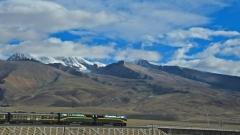
From Lhasa (Top Overland Choice): This is the most popular option, perfect for those wanting to gradually acclimatize to high-altitude climates. As shown on the Kailash Mountain map, the 1,500-kilometer route follows G318 to G219, passing through Xigaze, Everest Base Camp, Saga, Zhongba, and finally reaching Darchen. Most of the road is asphalt, manageable for regular SUVs, and the journey offers stunning views of Yamdrok Lake and Karola Glacier, making acclimatization more comfortable. Allocate 4 days for this trip to avoid rushing, which can trigger altitude sickness (AMS).
From Kathmandu (Sino-Nepal Border Overland): Ideal for travelers coming from Nepal and surrounding areas. Mark the route on your map as Kathmandu → Rasuwa Fort → Gyirong Port → Saga → Darchen. You’ll need to apply for a Tibet Travel Permit and a Chinese group visa in advance. This route blends Sino-Nepali border culture and scenery—take a short rest in Gyirong Town to acclimatize before reaching Darchen.
By Plane + Overland: For time-constrained travelers, fly directly from Lhasa to Ngari Gunsa Airport, then take a 200-kilometer drive to Darchen. However, this sudden altitude gain is highly likely to cause AMS, so it’s not recommended for first-time Tibet visitors. Mark the mandatory route from the airport to Darchen on your Kailash Mountain map and arrange transfer vehicles in advance to avoid being stranded upon arrival.
Navigation Warning: Never search directly for “Kailash Mountain”—it may lead you to a small hill with the same name. Use the correct keyword: “Kailash Mountain Viewpoint, Purang County, Ngari Prefecture, Tibet.” Also, download the Purang County offline map pack beforehand to ensure accurate navigation even in uninhabited areas.
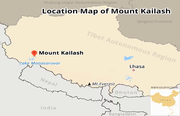
Location Map of Mount Kailash
Full Pilgrimage Process: Unlock the 3-Day Itinerary with Kailash Mountain Map
Pilgrimage (known as “kora”) is the core of experiencing Kailash Mountain. Every node marked on the Kailash Mountain map corresponds to unique scenery and challenges. Below is a tested 3-day classic kora itinerary, suitable for most travelers’ physical fitness and needs:
Day 1: Darchen → Zhore Monastery
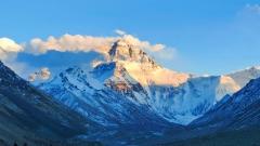
On the Kailash Mountain map, this route starts with a 6-kilometer car ride along the highway to save energy and quickly adapt to the initial altitude, followed by a hiking section north along the Laqu Gorge. After departure, you’ll pass the Prayer Flag Square—the best spot to get your first full view of the sacred mountain. Its pyramid-shaped peak against fluttering prayer flags is truly breathtaking. Continue to Chugu Monastery (4,860m), a 13th-century ancient temple built against a cliff, where Milarepa is said to have practiced. Take a short break to pray before finally reaching Zhore Monastery (5,210m), the key accommodation for Day 1. Backed by the sacred mountain, it offers stunning starry skies at night and the chance to witness the golden sunrise over the mountain in the morning.
Day 2: Zhore Monastery → Zutrul Phuk Monastery
This is the most challenging day of the kora. As seen on the Kailash Mountain map, the route climbs from Zhore Monastery to Drolma La Pass (5,648m) before descending all the way to Zutrul Phuk Monastery—no car rides, so physical fitness is a must. Depart at 5 AM to tackle the highest point while you’re still energetic. When passing the Sky Burial Site (≈5,375m), remain solemn—no noise or photography. Upon reaching Drolma La Pass, pause under the prayer flag array to gaze at Lake of Compassion, which shimmers like an emerald embedded in the snow-capped landscape, and feel the power of faith. After descending, head to Zutrul Phuk Monastery (4,830m) to replenish with hot water and food before ending the day’s journey.
Day 3: Zutrul Phuk Monastery → Darchen → Zhada
As indicated on the Kailash Mountain map, the first half of this route is a gentle downhill hike from Zutrul Phuk Monastery to Darchen, totaling 7km with low difficulty—slow down to reflect on the journey. Along the way, you’ll encounter pilgrims, whose devotion will deepen your understanding of this trip. Upon reaching Darchen, your kora is complete. After a short rest, take a 4km drive to Zhada County. Later, you can visit classic attractions like the Guge Kingdom Ruins and the Earth Forest Landform to enrich your Ngari adventure.
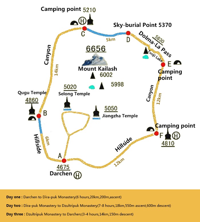
Mount Kailash Kora Route Map
Hidden Keys on Kailash Mountain Map: Mark Supply & Safety Nodes
Supplies and safety are crucial during the kora. Marking supply points, medical stations, and accommodation on your Kailash Mountain map in advance will make your journey more secure:
Accommodation & Supply Points: Accommodation is tight during peak season (July-September), so book in advance via the contact information marked on the map. Near Zhore Monastery, options include Gangjia Hotel and Pilgrim Guesthouse; there are also dedicated accommodation spots in the Immovable Nail Area (Budhisattva’s Nail Area), and Zutrul Phuk Monastery offers basic accommodation for rest. For supplies, Chugu Monastery, Zhore Monastery, and Zutrul Phuk Monastery all provide hot water and simple meals made with local high-altitude ingredients. It’s recommended to bring your own high-calorie snacks like chocolate and energy bars to cope with the energy consumption of long hikes.
Medical & Rescue Services: The scenic area has 4 key medical stations—mark their exact locations and contact information on your Kailash Mountain map: Zhore Monastery Medical Station, Dondrub Zhongkang Medical Station, Immovable Nail Medical Station, and Sangye Melong Medical Station. Follow road signs along the way. If you’re exhausted, the scenic area offers uniformly managed porter and horse-riding services—contact staff on-site for assistance. Never push yourself, as this can lead to dangerous conditions like severe AMS.
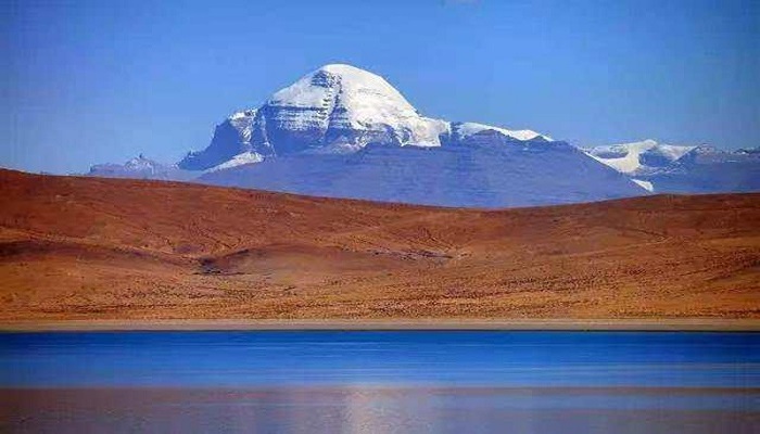
Mount Kailash
Practical Tips: Essential Information Beyond the Kailash Mountain Map
Best Travel Time: Kailash Mountain Scenic Area officially opens on April 25th each year and closes from December to April (heavy snowfall and extreme weather). The golden period for kora is July-September, with stable weather and an average temperature of 5-15℃. May-June offers clear air, perfect for photography, but be prepared for occasional rain and snow. September-October sees grasslands turn yellow and skies turn bright blue—another great choice.
Gear Preparation: Based on the high altitude and changeable climate marked on the Kailash Mountain map, gear should prioritize layered warmth, lightness, and practicality. Core gear includes: windproof and waterproof jacket, fleece jacket, quick-dry underwear, high-top waterproof hiking boots, hiking poles, headlamp, and insulated water bottle. For protection: SPF50+ sunscreen, sunglasses, sunhat, and lip balm (to combat strong UV rays and dryness). For medicine: start taking Rhodiola rosea 7 days in advance, and carry Gaoyuan’an (altitude sickness medicine), painkillers, and glucose with you.
Notes: To travel to Ngari Prefecture, apply for a border permit in advance—preferably at your place of household registration (free of charge) to avoid delays on-site. Respect local beliefs during the kora: do not step on prayer flags or mani stones, and ask for permission before photographing pilgrims. Bring your own garbage bags to protect the mountain’s ecological environment. To cope with AMS: walk slowly, drink plenty of warm water, and avoid strenuous exercise. If you experience severe headaches or difficulty breathing, contact a medical station or descend immediately.
Why Understanding the Mount Kailash Map Is Essential for a Safe Kora
Mount Kailash is not a destination you simply arrive at—it is a journey that demands preparation, awareness, and respect for the high-altitude environment. For most travelers, the success of the Mount Kailash kora does not depend on physical strength alone, but on whether they truly understand the Mount Kailash map before setting foot on the trail.
A well-prepared Mount Kailash map does far more than mark Darchen, Dirapuk Monastery, or Drolma La Pass. It reveals the full structure of the 52-kilometer circumambulation, showing daily elevation changes, critical rest points, supply locations, and medical stations—information that becomes vital once mobile signals disappear in the remote Ngari region.
Whether you are a pilgrim following an ancient spiritual path or a trekker drawn by the raw landscape of western Tibet, offline maps, correctly labeled waypoints, and realistic route planning are essential for minimizing altitude risks and avoiding unnecessary detours. When you finally stand atop Drolma La Pass and look back on the trail you’ve completed, you’ll understand one truth clearly: the Mount Kailash map is not optional—it is the foundation of a safe and meaningful kora.