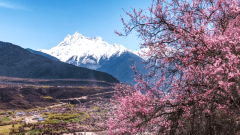
Ngari Prefecture, located in northwestern Qinghai-Tibet Plateau, boasts an average altitude exceeding 4,500 meters. Vast and sparsely populated, it harbors breathtakingly pristine natural scenery and profound, unique religious culture. Whether it’s the majestic Mount Kailash, the crystal-clear Lake Manasarovar, the mysterious ruins of the ancient Guge Kingdom, the boundless Changtang Grassland, or the dazzling night sky, Ngari never fails to deliver unparalleled spiritual and visual experiences. This article systematically organizes Ngari’s tourist attractions from a map perspective, helping you explore this ultimate destination that integrates sacred mountains, holy lakes, historical civilizations, and wilderness secrets.
Regional Distribution of Ngari’s Tourist Attractions
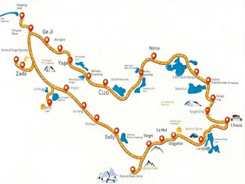
Ngari’s attractions are widely scattered. Based on major transportation routes (National Highway G219 Xinjiang-Tibet Line, National Highway G317 Northern Ngari Line, etc.) and cultural-geographical units, it can be divided into the following core tourist areas for easy itinerary planning:
- Southern Ngari Core Area (Sacred Mountains & Lakes Region): Centered on G219 Xinjiang-Tibet Line, covering Purang County and southern Gar County (Shiquanhe Town). As the essence of Ngari travel, it gathers iconic sites like Mount Kailash, Lake Manasarovar, and Lake Rakshastal, along with key supply points such as Tarchen and Purang. It is the primary area for first-time visitors to Ngari.
- Zanda Earth Forest & Guge Ruins Area: Located in southwestern Ngari (Zanda County), featuring the grand Zanda Earth Forest landforms and the mysterious Guge Kingdom ruins. Surrounding attractions include the Donggar-Piyang Grottoes and Tholing Monastery. Accessible from the Sacred Mountains & Lakes Region via Baer Checkpoint.
- Northern Ngari Line (Changtang Grassland Scenic Area): Extending along G317 National Highway (Northern Ngari Line), covering Geji County, Gaize County, Cuoqin County, and reaching Nima County and Bangor County in Naqu City. Highlighted by vast alpine meadows, groups of wild animals (Tibetan antelopes, Tibetan wild asses, etc.), and scattered plateau lakes (Lake Zhari Namco, Lake Dangre Yongco, etc.), it offers rugged and adventurous scenery.
- Rutog-Bangong Co Area: Situated in northwesternmost Ngari (Rutog County), centered on the picturesque Lake Bangong Co (Cuomang La Renbo). The lake area is home to flocks of waterbirds and boasts pleasant scenery. It is also the first stop entering Tibet via the Xinjiang-Tibet Highway.
- Shiquanhe Town (Prefectural Capital): As the administrative, transportation, and supply hub of Ngari, Shiquanhe Town (Gar County) features attractions like Ngari Dark Sky Park and Shiquanhe Wetland. It serves as an ideal base for itinerary adjustments and rest.
Detailed Guide to Ngari Tour Routes
Natural and Cultural Wonders in Ngari
Natural Wonders
- Mount Kailash: Located in northern Purang County, it is revered as the “World Center” by Tibetan Buddhism, Hinduism, Jainism, and Bon. With its unique pyramid-like shape and year-round snow cover, it is the most sacred pilgrimage site for believers and an ultimate challenge for hikers.
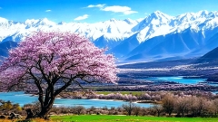
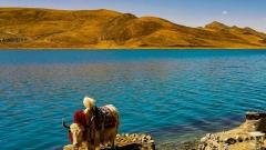
- Lake Manasarovar: Situated southeast of Mount Kailash in Purang County, known as the “Jade Lake of the West” and “Mother of Holy Lakes.” As one of the sources of Asia’s four major rivers, its crystal-clear waters are believed by believers to purify the soul.
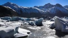
- Lake Rakshastal: Adjacent to Lake Manasarovar, it has brackish water and desolate surroundings, forming a striking contrast with the serene holy lake. Its scenery is eerily magnificent.
- Zanda Earth Forest: Covering the entire Zanda County, this unique landform is shaped by millions of years of wind and rain erosion. With crisscrossing gullies and dense earth pillars, it resembles an otherworldly wilderness, especially stunning at sunset.
- Lake Bangong Co: Straddling the China-India border in Rutog County, it is an international lake with freshwater in the eastern part and saltwater in the western part. Rich in ecology, its bird islands are inhabited by numerous migratory birds, offering beautiful scenery.
- Lake Zhari Namco: An important lake on the Northern Ngari Line, located northeast of Cuoqin County. As Tibet’s third-largest lake, it features a vast expanse of deep blue water, and its lakeside grasslands are ideal for observing wild animals.
- Qiangtang National Nature Reserve (Partial): Covering a large area in northern Ngari, it is China’s largest nature reserve, boasting a unique alpine ecosystem. It is a paradise for rare wild animals such as Tibetan antelopes, Tibetan wild asses, and wild yaks.
Cultural Landscapes
- Guge Kingdom Ruins: Located along the Xiangquan River in Zanda County, the ruins of this mysterious kingdom that vanished overnight over 300 years ago include well-preserved palaces, temples, caves, and murals. They witness the glory of the former kingdom and stand as the pinnacle of Ngari’s cultural attractions.
- Tholing Monastery: Situated in Zanda County seat, it was the first Buddhist monastery built during the Guge Kingdom era. Playing a pivotal role in the later propagation of Tibetan Buddhism, it houses exquisite murals.
- Donggar-Piyang Grottoes: Located in northern Zanda County, these ancient grottoes served as important monasteries and residences during the Guge Kingdom. Their murals are vivid in color and rich in content.
- Korga Monastery: Located in Korga Village, Purang County, this ancient Sakya Sect monastery features unique architectural styles and rich collections.
- Rutog Rock Art: Distributed across multiple sites in Rutog County, these rock carvings by ancient ancestors depict scenes of hunting, herding, and dancing, serving as precious materials for studying Tibet’s early history and culture.
- Gar County Seat: As the seat of Ngari Prefectural Government, it is the modern political, economic, and cultural center of Ngari. Equipped with museums, memorial halls, and Ngari Dark Sky Park, it is a key supply and information hub.
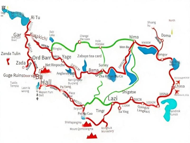
Ngari Loop Tourist Attractions
Ngari’s Core Transportation Network
- National Highway G219 (Xinjiang-Tibet Line): Connecting Yecheng (Xinjiang) and Lhasa (Tibet), it is the primary access route to Ngari, traversing the core of Southern Ngari (Rutog, Shiquanhe, Baer Checkpoint, Purang).
- National Highway G317 (Northern Ngari Line): Extending east from Shiquanhe through Geji, Gaize, and Cuoqin to Naqu, it is the core route for experiencing Changtang’s scenery and visiting multiple lakes. Road conditions are relatively harsh.
- Provincial Highways S207, S302, etc.: Connecting main highways to county seats (e.g., Zanda, Purang) and specific attractions (e.g., Zanda Earth Forest, Guge Ruins).
- Air Travel: Ngari Gunsa Airport is located in Gar County, approximately 50 kilometers from Shiquanhe Town. It operates flights to/from Lhasa, Chengdu, Urumqi, and other cities, offering a fast way to travel to/from Ngari, though flights are often affected by weather.
- Long-Distance Buses: There are regular buses between Lhasa and Shiquanhe Town, but they have few departures, long travel times, and do not allow stops at attractions along the way, making them not recommended for tourists.
Q&As for Ngari Travel
Q1: What is the best time to visit Ngari?
The best time is from May to early October. July-August is the warmest period with green grasslands, but it is also the rainy season (mostly night rains), which may lead to muddy roads. September-October offers clear skies and cool weather, making it the best season for photography, though temperatures drop sharply after October. Winter (November-April) is extremely cold with heavy snowfall blocking roads, and most attractions are closed, making it unsuitable for travel.
Q2: Ngari has a high altitude. How to prevent and cope with altitude sickness?
Maintain good physical condition before the trip and consider taking Rhodiola rosea 1-2 weeks in advance. Spend 2-3 days acclimatizing in Lhasa before gradually entering Ngari. Move slowly during the trip, avoid strenuous exercise, drink plenty of warm water, eat light meals, and supplement sugar in moderation. Ensure adequate sleep but avoid taking sleeping pills.。
Q3: What are the accommodation and dining conditions like in Ngari?
Accommodation: Shiquanhe Town has well-equipped hotels; county seats like Purang, Zanda, and Rutog offer clean guesthouses or hostels; Tarchen has numerous family-run inns. Accommodation in towns along the Northern Ngari Line is very basic, with possible shared rooms or bunk beds.Dining: Sichuan cuisine and Tibetan cuisine are the main options, with more choices in county seats. Along the way, noodles and stir-fries are common, while vegetables are scarce and expensive.
Why Ngari Is Tibet’s Ultimate Destination for Culture, Faith, and Wilderness
Ngari, also known as Ali, represents the most remote and spiritually profound region of Tibet. Located on the northwestern edge of the Tibetan Plateau, this vast land combines sacred mountains, holy lakes, ancient civilizations, and some of the most untouched wilderness on Earth. From Mount Kailash and Lake Manasarovar to the ruins of the Guge Kingdom and the endless Changtang grasslands, Ngari offers a travel experience defined by scale, solitude, and meaning.
Understanding Ngari through a travel map is essential due to its immense size and scattered attractions. Sacred sites are concentrated along the southern route, while archaeological remains lie to the southwest, and high-altitude lakes and wildlife dominate the northern route toward the Changtang region. This gradual shift from spiritual landmarks to raw natural landscapes makes Ngari a destination that requires careful planning, respect for altitude, and an appreciation for slow travel.