Panlong Ancient Road: The Honest, Walk-Every-Corner Guide
I walked, climbed, and stopped at every single place you’re allowed to stop along Panlong Ancient Road.
And here’s the truth no one tells you online:
Most guides never explain where to actually take photos, and many of the “epic” shots you see are either drone footage or heavily edited.
If you’re a normal traveler with a normal phone and normal stamina, this guide is for you.
Follow it, and you’ll save energy, avoid altitude sickness, skip useless climbs, and still get the best views.
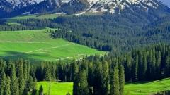
Panlong Ancient Trail
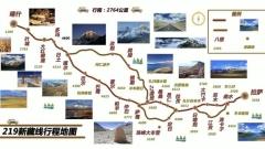
📍 Where Is Panlong Ancient Road?
Panlong Ancient Road, officially known as Waqia Road, is located in
Waqia Township, Tashkurgan Tajik Autonomous County, Kashgar Prefecture, Xinjiang.
-
Total length: ~30 km
-
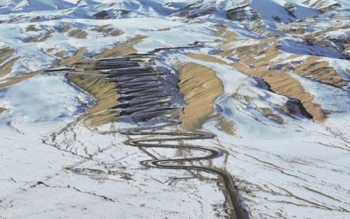
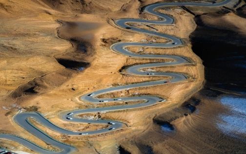
Over 600 S-curves and U-turns
-
Elevation rises from 3,000 m to 4,100–4,200 m
Because of the altitude and dense curves, this is not a “stop anywhere and shoot” road.
📅 Best Time to Visit
March to November is ideal.
-
Stable road conditions
-
Best mix of grassland, valleys, and snow peaks
-
Heavy snow may close the road after October
⚠️ Always check weather and road status before departure.
🚗 Transportation & Driving Rules (Read Carefully)
🚦 Road Regulations
-
One-way only
-
Entry from Big Panlong → exit via Small Panlong
-
Vehicles with 7 seats or more are prohibited
⚠️ Self-Driving Tips
-
Not recommended for drivers without mountain or high-altitude experience
-
Extremely frequent curves
-
Motion sickness is common—even for people who normally don’t get carsick
🎒 Preparation Checklist (Non-Negotiable)
📄 Documents
-
Passport or Chinese ID
-
Border Permit (must be obtained in Kashgar in advance)
👉 Missing either means you won’t be allowed through.
🎒 Essentials
-
Motion sickness medicine
-
Portable oxygen canisters
-
Sunglasses, sunscreen, hat, UV-protective clothing
-
Warm jacket (weather changes fast)
Panlong Ancient Trail
⚠️ Important Warnings from Experience
-
Very few toilets along the route
-
Traffic jams during holidays make bathroom stops painful
-
Fuel up in Tashkurgan at night to avoid long daytime lines
-
If you feel unwell at altitude, stop immediately—don’t push
📸 Photo Rules That Actually Work
👉 On the Way Up
Don’t shoot. Don’t stop. Don’t bother.
-
Low viewing angles
-
Curves don’t look impressive
-
Not worth the effort
📌 Focus on driving safely uphill.
👉 On the Way Down (This Is the Key)
All worthwhile photo spots are on the descent.
And no, not every viewpoint is worth stopping at.
🎯 Photo Spot Rankings (Tested)
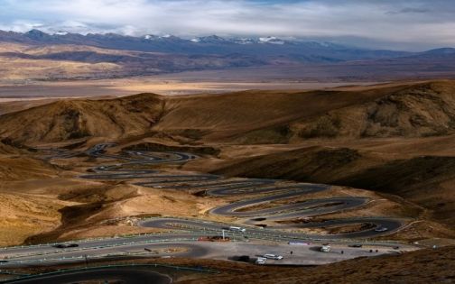
✅ TOP Pick: Longji Mountain Boardwalk (Must-Visit)
📍 Search “Longji Mountain” on the map.
-
Roadside parking
-
5-minute walk up a short boardwalk
-
Clear, layered S-curves visible to the naked eye
-
Works perfectly with a phone camera
👉 About 90% of the iconic Panlong photos online are taken here.
📌 For most people, this spot alone is enough.
✅ Nearby Casual Stops
-
Decent views
-
Minimal walking
-
Good as supplementary shots
❌ Blacklist: Double Dragon Playing with Pearl Viewpoint
Trust me—skip it.
-
Long, exhausting climb
-
Very high altitude
-
Nothing impressive at the top
I nearly got altitude sickness, and even the drone operators said it wasn’t worth filming.
👉 Skip it and save your energy.
Panlong Ancient Trail
💡 A Reality Check
Those dramatic “perfect Panlong curves” you see online?
-
Either shot by drones
-
Or heavily edited afterward
📌 For normal travelers, Longji Mountain already delivers an outstanding view.
✈️ Lazy Traveler Bonus: Drone Services
-
Drone operators are often available roadside
-
Cost: 160–260 RMB
-
Cheaper—and easier—than climbing useless viewpoints
📌 Best way to get an aerial shot without exhausting yourself.
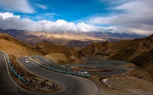
🧭 Viewpoints Along the Route (Honest Reviews)
① Long Huitou Viewpoint
❌ Crowded, flat perspective
Not worth stopping
② Water Sleeve Viewpoint (4,150 m)
❌ Some depth, but lacks S-curve feel
Skip it
③ Wanglong Pavilion (Longji Mountain Trail)
✅ Key viewpoint
-
No parking here
-
Park at the next stop and walk back
-
Best for wide landscape shots
④ Big Panlong Viewpoint
✅ Parking available
-
Props and seating
-
Phone or camera both work
-
Small purchase required (the lamb skewers are good)
⑤ Small Panlong Viewpoint
✔️ Optional
Looks underwhelming after Big Panlong
⑥ Small Panlong Exit
✅ Drone hotspot
Great contrast of S-curves and straight road
Panlong Ancient Trail
📌 Final Tips You’ll Be Glad You Knew
1️⃣ Searching “Panlong Ancient Road” only takes you to the entrance, not photo spots
2️⃣ Start/end slogan signs are dusty and overcrowded
3️⃣ There’s a toilet at the Small Panlong exit—but it’s extremely dirty
🌄 Suggested Route Pairing
On a clear day, do this:
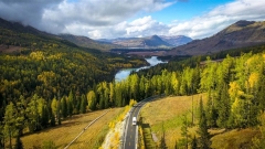
👉 Panlong Ancient Road + Bandir Blue Lake
After hundreds of tight curves, suddenly opening into a vast blue lake—
it truly feels like:
“After all the twists in the road, life finally opens up.”