Details
Lhasa – Yamdrok Lake – Gyantse – Shigatse 360km
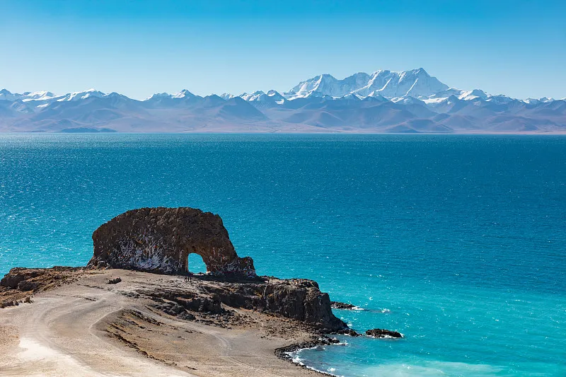
Depart from Lhasa in the morning, cross the Gangbala Snow Mountain at an altitude of 4990 meters, overlook the Gangbala Reda Station, and follow the old road to the world’s highest freshwater lake, Yamdrok Lake, which is known as the holy lake in the sky (the lake surface is 4441 meters above sea level, the lakeshore is 250 kilometers long, and the area is 638 square kilometers). “Jade Lake” in Tibetan is a freshwater lake that is one of the three holy lakes in Tibet. The lake water is as clear as sheep fat, and the lake water is sweet and can be drunk. It is the filming location of the movie “Red River Valley”. The azure blue lake is connected to the snow-capped mountains in the distance, and the colorful mountains on both sides, the unique Tibetan ethnic villages, and the cattle and sheep everywhere make the journey refreshing.
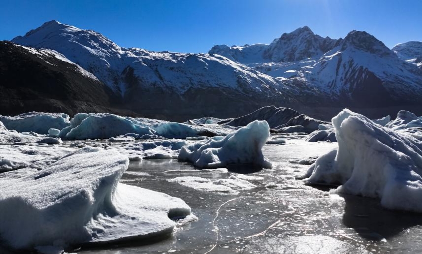
Pass by Guankaruola Glacier: the sleeping ice beauty (crystal blue, majestic, misty, peerless beauty, not only the geological history written by the flowing years and ice and snow, but also the great art sculptured by time).
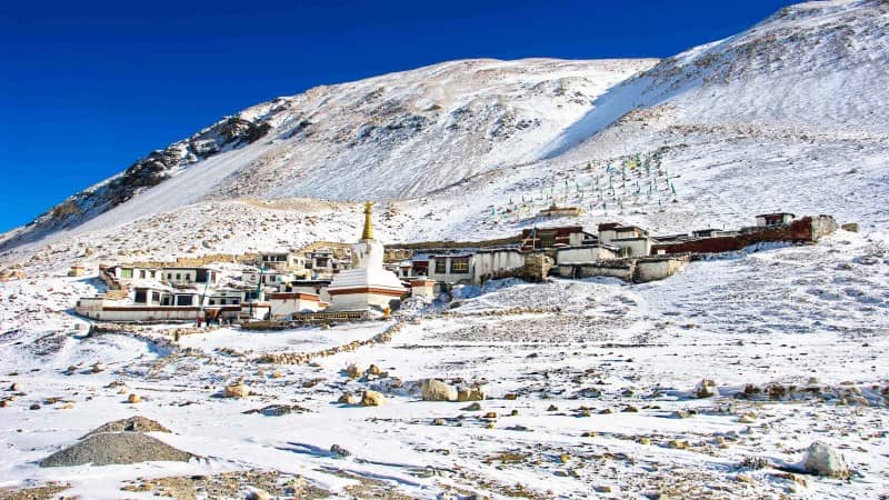
Visit Pelkhor Choede(Kumbum), the only place that integrates the three major Tibetan sects and is famous for its exquisite murals and carvings, and visit Zongshan Anti-British Platform (the heroic site of the Anti-British Army, and feel the grace of the heroic city); take a car to Shigatse. On the way, you may be lucky enough to see Buddhists prostrating themselves on the snowy plateau, measuring the pilgrimage road with their flesh and blood, and trekking hard towards the holy land in their hearts.
Accommodation: Shigatse
Shigatse – Tashilhunpo Monastery – Mount Everest (350 km)
Visit the seat of successive Panchen Lamas, Tashilhunpo Monastery, one of the six great monasteries of the Gelug school, founded in 1447. The monastery is built against a hillside, its golden roofs and red walls forming a majestic and harmonious complex of halls and residences nestled into the mountain slope. Its grand architecture, shimmering golden domes, and layered buildings exude solemn magnificence.
Inside, incense smoke spirals into the air and butter lamps flicker before richly decorated altars. Monks chant scriptures in orderly harmony, and statues of various Buddhas are worshipped by devoted pilgrims bowing in reverence. For over 500 years, this monastery has attracted Buddhist followers from across China and abroad. The monastery houses the world’s largest indoor bronze statue—a 26-meter-high Maitreya Buddha, and the stupa of the 10th Panchen Lama.
In the afternoon, arrive at the Mount Everest National Nature Reserve, the highest of its kind in the world. Facing south from Rongbuk Monastery (optional entry), the world’s highest monastery, is regarded as the best vantage point for viewing Mount Everest. At 5,100 meters, white stupas rise amid flapping prayer flags. From here, take an eco-vehicle to reach the Everest Base Camp at 5,200 meters, where you can stand face-to-face with the highest peak on earth—Mount Qomolangma (Everest). With luck, you may even witness the iconic “flag cloud” fluttering like a flame over its summit.
Accommodation: Rongbuk Monastery
Mount Everest – Rongbuk Monastery – Saga (260 km)
On the way to Saga, enjoy distant views of Mount Shishapangma, located in Nyalam County, to the northwest of Mount Everest. As one of the highest peaks in the Himalayas, it stands at 8,012 meters, making it the 14th highest mountain in the world.
The north face of Shishapangma features complex terrain with steep slopes riddled with crevasses, where icefalls and avalanches occur frequently. The largest glacier on the north side, Yebokangal Glacier, winds through the valleys like a jade dragon, with towering ice pinnacles resembling shimmering scales in distinct layers.
In contrast, the southern slope has a warm and humid climate. Rhododendron forests grow up to 4,700 meters, while bamboo forests thrive below 3,500 meters. The area is rich in biodiversity, home to colorful sunbirds, long-tailed leaf monkeys, and even the elusive red panda, which may be seen alone or in small groups.
Accommodation: Saga
Saga – Zhongba – Paryang (360 km)
Paryang Grassland:
Paryang is a small town in Zhongba County, rich in western Tibetan charm. Here, you can admire the traditional attire of local Tibetan residents, and witness herds of yaks and sheep roaming freely between verdant grasslands and snow-capped mountains—creating a picturesque, pastoral scene straight out of a painting.
Along the way lies a paradise for wildlife, including wild yaks, Tibetan antelopes, goa antelopes (yellow sheep), and kiangs (Tibetan wild asses). The landscape is dotted with countless majestic snow-covered peaks, towering and dramatic, and home to numerous crystal-clear lakes and vast, seemingly endless grasslands.
Accommodation: Paryang
Paryang – Mayum La Pass – Sacred Lake Manasarovar – Mount Kailash (280 km)
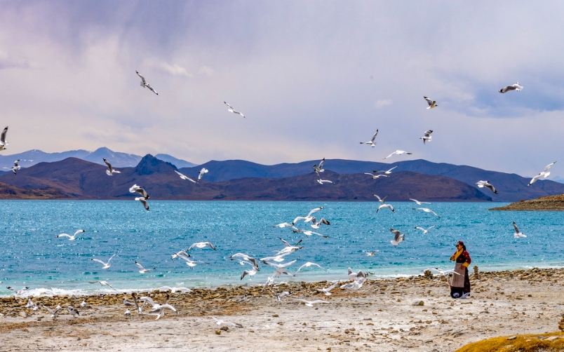
Lake Manasarovar:
Located about 20 km southeast of Mount Kailash and north of Mount Naimona’nyi, Lake Manasarovar sits at an altitude of 4,588 meters, covering an area of 412 square kilometers with a maximum depth of 70 meters. Though it may not be the largest, deepest, or highest lake on the Tibetan Plateau, Manasarovar is revered as the Queen of the Plateau’s lakes.
It is considered one of the most sacred lakes in Asia—if not the world—by followers of Bon, Tibetan Buddhism, Hinduism, and Jainism. Devotees believe it is a gift of nectar from the Buddha, capable of washing away physical impurities and cleansing the five poisons of the mind. Pilgrims bathe in the lake and collect its water to take home as a precious offering to family and friends.
On clear days, the lake turns a deep blue, with gentle ripples reflecting snow-capped peaks and drifting clouds. Distant mountains encircle the lake in breathtaking serenity, making it one of the most stunning landscapes in Tibet.
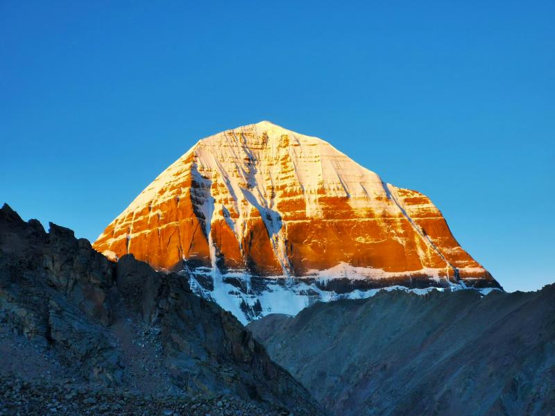
Mount Kailash:
The main peak of the Gangdise Range, Mount Kailash rises to 6,638 meters. In Sanskrit, it is known as the “Abode of Shiva,” while in Tibetan it is called the “Sacred Mountain.” With its perfectly symmetrical pyramid shape (likened by locals to a “grinding stone handle”), the mountain presents a striking silhouette.
From the south, its most iconic feature can be seen: a vertical glacier descending from the summit intersects with a horizontal rock layer, forming a Swastika symbol, a Buddhist emblem representing spiritual power, eternal Dharma, and good fortune.
The peak is often shrouded in white clouds, and locals believe that catching a glimpse of its summit is an auspicious blessing. Mount Kailash is revered globally and regarded as the center of the world by Hinduism, Tibetan Buddhism, Bon, and Jainism.
Accommodation: Darchen
Stay at the Sacred Mountain and Holy Lake for Photography
Spend the entire day in Darchen, capturing the holy Mount Kailash and the sacred Lake Manasarovar. This is a rare opportunity to photograph the majestic pyramid-shaped peak of Kailash and the serene, turquoise waters of Manasarovar under changing light and weather—ideal for landscape and spiritual photography.
Mount Kailash – Zanda County(350 km)
Traveling south from Shiquanhe along the Riyue Highway for about 255 km, you’ll enter the Sutlej River Valley and arrive at Zanda County in Ngari Prefecture. This region is renowned for its spectacular earth forest landscape.
The Zanda Earth Forest was formed by ancient tectonic movements and the long-term erosion of lakebed sediments. Over time, wind and water carved the terrain into a unique geological wonder. The towering formations, some tens of meters high, resemble twisted trees or giant sculptures, creating an otherworldly atmosphere. Driving through the area feels like circling around the feet of giants.
Accommodation: Zanda County
Full Day Photography: Guge Kingdom Ruins & Zanda Earth Forest (80 km)
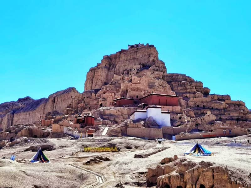
In the early morning, head to the Ruins of the Guge Kingdom, located 7 km outside of the county seat, to capture the sunrise. As you gaze up at the majestic remains of the ancient royal citadel, you’ll see that the structures are arranged in a meticulous hierarchical layout on a 300-meter-high clay hill. Scattered across the slope are the remnants of palaces, meditation caves, watchtowers, stupas, and fortress walls, offering a glimpse into the grandeur of the once-powerful Guge Kingdom.
After the visit, return to Zanda town. Following lunch, explore the Tholing Monastery, which boasts over 900 years of history. The monastery’s architecture and statues reflect a blend of Indian Kashmiri, Ladakhi, and Nepalese styles. Surrounding the monastery are the ruins of more than 100 ancient stupas, while inside, ancient murals hint at the monastery’s former glory.
Accommodation: Zanda County
Zanda County– Guge Ruins – Shiquanhe (280 km)
Guge Ruins:
The Guge Kingdom traces its origins back to the ancient Zhangzhung Kingdom. It was established around the 9th century, following the collapse of the Tubo (Tibetan Empire), and lasted until the 17th century, spanning 16 generations of hereditary kings. Guge was a local regime founded by the descendants of the Tubo royal family in western Tibet’s Ngari region, and at its peak, its rule extended throughout the entire region of Ngari.
Shiquanhe Town (Gar):
Located at the junction of the Shiquan River and the Xinjiang–Tibet Highway, Shiquanhe is the administrative and economic center of Ngari Prefecture.
Accommodation: Shiquanhe
Shiquanhe – Pangong Lake – Shiquanhe (300 km)
Depart in the morning to visit Pangong Lake, one of the most famous birdwatching sites in Tibet. The lake is home to hundreds of bird species, making it a true paradise for birdlife on the plateau. In the afternoon, return to Shiquanhe.
Shiquanhe – Rutog (220 km)
Depart for Rutog, a small border county in Ngari Prefecture. Shortly after leaving Gar (Shiquanhe), a turn onto a dirt slope reveals a panoramic view of the entire county town. The road winds through the wilderness, passing through vast wetlands, where flocks of wild ducks, grey ducks, and bar-headed geese glide peacefully over the water.
Not long after, you’ll spot an ancient cliff on the right side of the road, where you’ll find the Rinmudong Rock Paintings. Though unprotected and weather-worn, some of the carvings still remain. These include Tibetan mantras, as well as figures of people and animals, all depicted with simple but expressive lines.
Continue onward and soon arrive in Rutog, a remote frontier town. Just 9 km past the county seat lies Pangong Tso, sitting at an elevation of 4,242 meters. The lake straddles the border with Kashmir—freshwater on the Chinese side, and saltwater on the Indian side.
Enjoy lunch by the lake, featuring local delicacies such as the high-altitude schizothoracin fish, a unique species of carp found only in Tibetan waters. After lunch, take a boat ride to the heart of the lake—home to the highest bird island in the world. The sky fills with soaring birds in a truly breathtaking spectacle. Nests and eggs are scattered across the island, as brown-headed gulls, wild ducks, grey ducks, and bar-headed geese gather here in large numbers to breed.
Accommodation: Rutog
Rutog – Gêrzê (500 km)
Depart early for Gêrzê. Breakfast will be enjoyed in the vehicle while traveling. Before dawn, the sky is filled with countless stars, seemingly close enough to touch. The vehicle speeds across the vast wilderness, and before long, you’ll reach the first lake—Rebang Co.
As the convoy continues, herds of Tibetan wild asses (kiangs) and goa antelopes (yellow sheep) occasionally dash across the plains, sometimes racing alongside the vehicles. The landscape is desolate and uninhabited, with hardly a trace of people. Every now and then, a small white stupa appears atop a hill, silently reminding travelers of the spiritual presence that persists in this remote land.
Passing Aung Co and merging back onto the main road, the group arrives at a small, rugged salt lake town, where lunch is taken. Afterward, the journey continues deeper into the wilderness, weaving past a series of scattered lakes of varying sizes.
Eventually, the road leads into the heart of the northern Tibetan plateau—Gêrzê, a relatively well-equipped town amid the vast highland wilderness.
Accommodation: Gêrzê
Gêrzê – Dongco – Nyima (421 km)
Depart early for Nyima, with breakfast served in the vehicle. The journey resumes across the vast wilderness. Before long, the first lake, Dong Co, comes into view. If the weather is clear, you’ll witness a breathtaking sunrise over the plateau lake.
After passing Dongco Town, the convoy splits from the Xiaobei Route and continues onward. Along the way, the vehicle passes the beautiful highland lake Zaxi Co, then enters the Nagqu Prefecture. The road runs endlessly through the desolate wilderness, with mountains stretching endlessly at the horizon—lonely and majestic.
Crossing the Chalanmula Pass, the journey enters the Changtang National Nature Reserve, a national-level protected area in northern Tibet. Lunch is either packed or enjoyed at a roadside stop—perhaps a bowl of Lanzhou-style noodles.
After lunch, continue across the high-altitude steppe, where herds of Tibetan wild asses and goa antelopes race alongside the vehicles. With luck, you may spot foxes or even the elusive Tibetan antelope (chiru).
Traveling over several ridges and mountain passes, you eventually arrive at Nyima County, located at an altitude of about 4,500 meters, in the heart of the northern Changtang grasslands.
Accommodation: Nyima
Nyima – Bangor (350 km)
Depart for Bangor County, enjoying a packed breakfast onboard the vehicle. The road continues through the boundless wilderness, but today’s journey features numerous lakes of various sizes. You’ll pass by the small lake of Zhangnai Co, followed by Wuru Co.
After reaching the small town of Nancuoze, stop for lunch at a roadside tent restaurant before continuing the journey. By evening, arrive at Bangor County, beautifully nestled between two of Tibet’s major lakes: Namtso and Serling Tso.
Accommodation:Bangor
Bangor – Namtso Lake (240 km)
Depart for Lake Namtso, leaving behind the northern Changtang Plateau and heading south. The vehicle travels across the Bangor Grasslands, winding up and down gentle hills. Along the way, you’ll pass many lakes, each with its own unique charm. A highlight is Bangor Co, a sacred lake surrounded by snow-capped peaks, meadows, and traditional Tibetan villages, forming a strikingly beautiful scene.
Enjoy a packed lunch en route, then continue the journey as the road stretches deep into the highland terrain. After crossing a snowy mountain pass, a panoramic view of Lake Namtso unfolds before you, with the Nyenchen Tanglha Mountain Range standing majestically in the background. Under the sunlight, the sacred lake glows with a breathtaking brilliance.
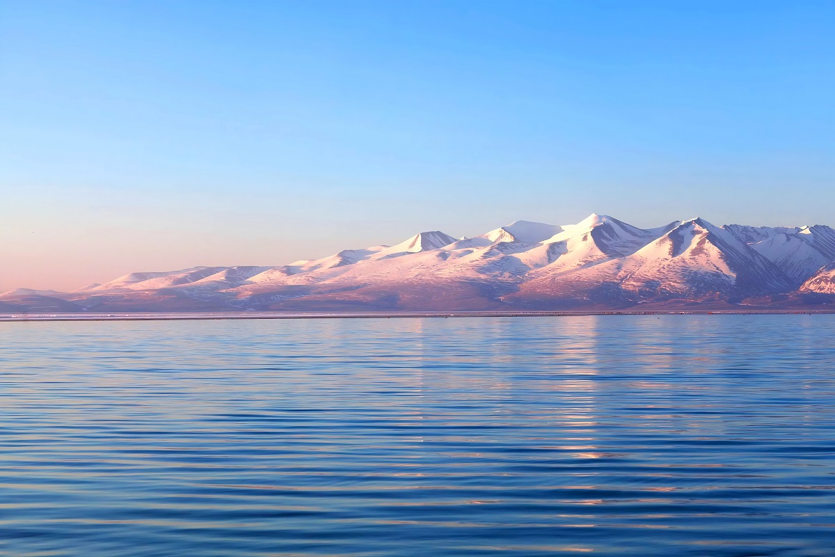
Descend to reach Lake Namtso, known as the “Heavenly Lake,” one of Tibet’s three great sacred lakes. It is the largest lake in Tibet and the second-largest saltwater lake in China. On the Tashi Peninsula, which extends into the lake, stands the Tashi Monastery, a renowned pilgrimage site. Once settled in, visitors can explore the island and lakeshore, visiting sights such as the Couple’s Rock, Praying Hands Stone, mani stone mounds, small shrines, and even climb to the hilltop for panoramic views and photography of the sacred lake.
Along the way, you can also admire the main peak of the Nyenchen Tanglha Range, rising to 7,717 meters.
Accommodation: Namtso Lake
Namtso Lake – Lhasa
In the early morning, enjoy the sunrise over Lake Namtso, a truly serene and sacred experience. Afterward, journey across the vast Changtang Grasslands, passing by the majestic Nyenchen Tanglha Mountains and the geothermal town of Yangpachen.
By evening, return to Lhasa, marking the end of your journey.
End of Tour
Fee Description
Inclusions:
To be discussed (customizable upon request)