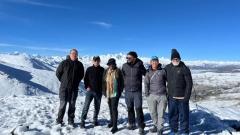
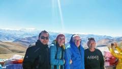
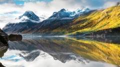
Tibet boasts magnificent snow-capped mountains, crystal-clear lakes, pristine meadows and unique profound Tibetan culture, a sacred and dreamy place for numerous passionate hiking enthusiasts. Whether a novice or an experienced outdoor enthusiast, you can easily find a suitable route here. The best hiking routes in Tibet let you get close to the magnificent plateau scenery, experience local pure beliefs and peaceful life rhythm while walking, gaining great visual and spiritual shock. Next, we will detail classic routes, practical pre-trip preparations and important precautions to help you start your unforgettable Tibet hiking journey smoothly.
Overview of Hiking Routes in Tibet
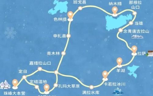
Hiking routes in Tibet are widely distributed, covering many regions such as Southern Tibet, Eastern Tibet and Northern Tibet, and each route has unique scenic features and difficulty levels. Overall, the hiking routes in Tibet are characterized by high altitudes, with most routes above 3,500 meters above sea level and some sections exceeding 5,000 meters, which have certain requirements on travelers’ physical fitness and plateau adaptability.
Most of these routes connect various landscapes such as snow-capped mountains, lakes, glaciers, temples and villages, combining natural scenery with cultural connotations. Some routes are pastoral roads that local herdsmen have been walking for a long time, some are paths for believers to pilgrimage around the mountain, and others are secret routes gradually developed by outdoor enthusiasts in recent years. In terms of difficulty, they can be divided into entry-level, intermediate and challenging levels, which can meet the needs of hiking enthusiasts at different levels.
Route Distribution Characteristics
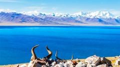
- Shannan Area: Represented by the Kula Kangri hiking route, the route is relatively mature with moderate difficulty, dense snow-capped mountains and lake scenery, suitable for novices to try plateau hiking.
- Nyingchi Area: Centered on the Medog hiking route, the route crosses multiple climate zones, with rich and diverse vegetation and great changes in scenery, making it a classic route with strong challenges.
- Ngari Area: The Mount Kailash circumambulation route is the most famous, which combines religious sacredness with hiking experience, and is the most representative circumambulation hiking route in Tibet.
- Shigatse Area: Including routes such as the East Slope of Mount Everest and Gamagou, it allows close contact with the world’s highest peak, with magnificent scenery, suitable for hikers pursuing extreme experiences.
Best Hiking Period
The climate varies greatly in different regions of Tibet. Choosing the right season to go not only can improve the hiking experience, but also ensure travel safety.
- Overall Best Time: From May to October every year, when the plateau temperature is relatively mild, precipitation is less, and road conditions are relatively stable, suitable for most hiking routes.
- Kula Kangri in Shannan: From June to September, wildflowers are in full bloom, the lake is blue, the scenery is the best, and the climate is also relatively comfortable.
- Medog in Nyingchi: From September to October, when the rainy season just ends, the risks of mudslides and landslides are reduced, and the route traffic conditions are the best.
- Mount Kailash in Ngari: From July to September, the temperature is suitable, there are many pilgrims and travelers circumambulating the mountain, and the supplies along the way are convenient.
Hiking Routes
Detailed Introduction to the Classic Best Hiking Routes in Tibet
Kula Kangri Hiking Route
The Kula Kangri hiking route is the first choice for entry-level hiking in Tibet, known as one of the best hiking routes in Tibet by many outdoor enthusiasts, suitable for travelers who are trying plateau hiking for the first time. The route is located in Lhoka County, Shannan City, close to Lhasa with relatively convenient transportation. The overall difficulty is mild, but the scenery is extremely shocking.
Basic Route Information
- Total Distance: About 75 kilometers
- Hiking Days: 5 to 7 days
- Highest Altitude: About 5,200 meters above sea level
- Difficulty Level: Entry to Intermediate
- Core Scenery: Kula Kangri Snow Mountain, Baima Lin Co, Zhegong Co, Jiejiu Co and other alpine lakes, as well as temples, mani piles, prayer flags and other cultural landscapes along the way.
Selected Itinerary Plan
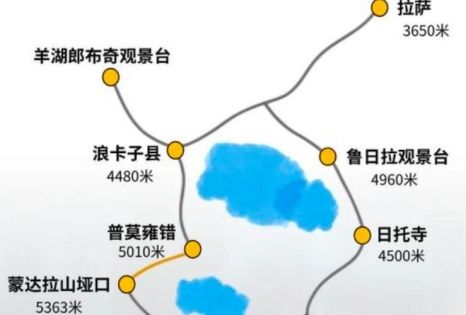
- Depart from Lhasa, pass through Yamdrok Lake and Pumoyong Tso to reach Lhoka County, adapt to the altitude and adjust physical condition.
- Travel from Lhoka County to Baima Lin Co, hike along the lake, and enjoy the beautiful scenery of Kula Kangri Snow Mountain reflecting in the lake up close.
- Go to Zhegong Co, hike through meadows and gravel slopes, and enjoy the magnificent scenery of multiple alpine lakes in a row.
- Cross Laka Ri Pass, overlook the panoramic view of mountains and lakes, and feel the unique charm of plateau hiking.
- Return by the original route or other routes, end the hiking trip and return to Lhasa.
Core Highlights of the Route
The biggest advantage of this route is its low threshold and high reward. It does not require extreme physical fitness or professional outdoor skills to get close to 7,000-meter-class snow-capped mountains. The route along the way is clear, mostly mature dirt roads and horse trails, and the daily hiking distance and climbing height are relatively mild. Ordinary people can complete it smoothly after making good plateau adaptation. While walking, you can not only feel the sacredness of the four major sacred mountains in Tibet, but also appreciate the stunning scenery of seeing three lakes from one mountain. It is a high-quality route with both safety and ornamental value.
Mount Kailash Circumambulation Hiking Route
Mount Kailash is a famous sacred mountain in Tibet, regarded as the center of the world by many religions. Circumambulating the mountain is not only an outdoor experience, but also a spiritual pilgrimage journey, and it is the route with the deepest cultural connotation among the best hiking routes in Tibet.
Circumambulation Route Information
- Total Distance: About 53 kilometers
- Hiking Days: 2 to 3 days
- Highest Altitude: About 5,630 meters above sea level
- Difficulty Level: Intermediate
- Core Scenery: Mount Kailash, Zhuomala Pass, temples along the way, and pilgrims circumambulating the mountain, allowing you to feel a strong religious and cultural atmosphere.
Circumambulation Itinerary Arrangement
- Start from Tacheng, hike to Zhezhapuk Monastery, climb slowly along the way to adapt to the altitude and enjoy the scenery of the north slope of the sacred mountain.
- Depart from Zhezhapuk Monastery and cross Zhuomala Pass, which is the highest and most difficult section of the circumambulation route, then descend to Renzhutun Monastery.
- Return from Renzhutun Monastery to Tacheng to complete the entire circumambulation, symbolizing the washing away of troubles and the purification of the soul.
Unique Circumambulation Experience
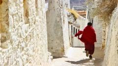
This route is the most classic circumambulation route in Tibet, attracting countless pilgrims and travelers every year. During the hike, you can walk with circumambulators from all over the world and feel the power of faith. The natural scenery along the way is magnificent and grand. The sacred mountain presents different styles under different lights. The prayer flags and mani piles at Zhuomala Pass are a true portrayal of Tibetan religious culture. For travelers who want to experience Tibetan religious culture and plateau hiking, this route is not to be missed.
Medog Hiking Route
Medog was once the last county in China to be connected by highway, known as the last secret land in Tibet. The Medog hiking route is a classic challenging hiking route in China, and also the route with the most diverse scenery changes among the best hiking routes in Tibet.
Medog Route Information
- Total Distance: About 96 kilometers
- Hiking Days: 6 to 8 days
- Altitude Drop: From 4,200 meters to 1,100 meters
- Difficulty Level: Advanced
- Core Scenery: Duoxiong La Snow Mountain, Yarlung Zangbo Grand Canyon, tropical rainforest, various vegetation and wild animals, experiencing the wonder of “one mountain has four seasons, ten miles different days”.
Medog Itinerary Plan
- Depart from Pai Town in Nyingchi, cross Duoxiong La Snow Mountain Pass, reach Laga, and feel the scenery change from temperate zone to frigid zone.
- From Laga to Hami, hike through primeval forests and walk along streams, with primitive and pure scenery.
- From Hami to Beibeng, the road section is relatively dangerous, allowing you to feel the grandeur of the Yarlung Zangbo River up close.
- From Beibeng to Medog County, enter the tropical rainforest area with lush vegetation and humid climate, which is completely different from the plateau scenery.
Features of Secret Scenery
The biggest feature of this route is its extremely large vertical drop. Along the way, you will experience multiple climate zones: frigid zone, temperate zone, subtropical zone and tropical zone, with various changes in vegetation and scenery. From snow-capped mountains and glaciers to tropical rainforests, from alpine meadows to canyon rapids, various landscapes converge in one line, providing an extremely rich hiking experience. However, the route is relatively difficult, with some dangerous sections, and there is a risk of landslides and mudslides in the rainy season. It is suitable for travelers with rich plateau hiking experience and good physical fitness.
East Slope of Mount Everest Hiking Route
The East Slope of Mount Everest hiking route allows people to get close to the majestic posture of Mount Everest, the world’s highest peak, and also enjoy the stunning scenery of Gamagou. It is one of the most shocking routes among the best hiking routes in Tibet.
Mount Everest Route Information
- Total Distance: About 100 to 150 kilometers
- Hiking Days: 7 to 10 days
- Highest Altitude: About 5,300 meters above sea level
- Difficulty Level: Intermediate to Advanced
- Core Scenery: Multiple 8,000-meter-class snow-capped mountains such as Mount Everest, Lhotse and Makalu, as well as primeval forests, meadows, glaciers and other landscapes in Gamagou.
Extreme Snow Mountain Experience
This route is located in the remote Gamagou, allowing you to appreciate the unique style of Mount Everest from the east slope. Along the way, there are many snow-capped mountains, well-developed glaciers and well-preserved primitive ecology. While walking, it is like being in a snow-capped mountain museum, with multiple world-class peaks appearing one after another, which has a strong visual impact. The route difficulty is medium to high, and some sections require yaks to transport supplies. It is suitable for hiking enthusiasts who want to challenge themselves and enjoy extreme snow-capped mountain scenery.
Hiking Routes
Practical Guide for Pre-Trip Preparation for Hiking in Tibet
Physical Adaptation Preparation
- Pre-exercise: 1 to 2 months before departure, properly carry out aerobic exercises such as jogging, swimming and hiking to improve cardiopulmonary function and physical fitness, so as to cope with the physical consumption of high-altitude hiking.
- Plateau Adaptation: After arriving in Tibet, do not start hiking immediately. First stay in low-altitude cities such as Lhasa for 2 to 3 days to adapt to the plateau climate, avoid strenuous exercise, and reduce the risk of altitude sickness.
- Health Check: Conduct a physical examination in advance to confirm that you do not have severe cardiopulmonary diseases, hypertension, anemia and other diseases that are not suitable for high-altitude activities.
Essential Equipment List
- Clothing: Windproof and waterproof jackets and pants, warm down jacket, quick-drying underwear, high-top non-slip hiking shoes, warm hat, gloves, hiking socks.
- Equipment: Hiking backpack, hiking poles, headlamp, sleeping bag, moisture-proof mat, outdoor pot, water cup, sunscreen, lip balm, sunglasses.
- Medicines: Altitude sickness medicine, cold medicine, gastrointestinal medicine, band-aids, disinfectant supplies, painkillers, etc.
- Others: ID card, relevant documents, a small amount of cash, mobile phone, power bank, map, navigation equipment.
Supplies and Documents Notes
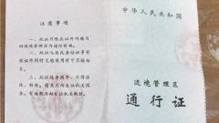
- Documents: ID card is a must. Some border areas require a border pass, which should be applied for in the place of household registration or Lhasa in advance to avoid affecting the itinerary.
- Food: Carry high-calorie and portable food such as chocolate, beef jerky, biscuits and nuts to supplement physical consumption during hiking.
- Water Source: Carry enough drinking water with you. Supplies are inconvenient in some sections along the way to avoid water shortage.
Safety and Civilization Precautions for Hiking in Tibet
Hiking Safety Notes
- Respect the Plateau Climate: The plateau weather is changeable, with large temperature differences between morning and evening, and sudden rainfall and snowfall. Add or remove clothes in time to do a good job in cold protection, warmth preservation and sun protection.
- Guard Against Altitude Sickness: Slow down during hiking, do not run or jump, drink more water and rest more. If you experience discomfort such as headache and nausea, stop advancing immediately, and descend to seek medical attention in severe cases.
- Do Not Act Alone: Some hiking routes in Tibet are sparsely populated with poor communication signals. It is recommended to travel in groups or follow professional guides to avoid hiking alone.
- Pay Attention to Road Safety: Some sections have gravel, steep slopes and slippery conditions. Focus on your feet while walking to avoid falling and getting injured. Pay attention to preventing geological disasters such as landslides and mudslides in the rainy season.
Civilized Hiking Guidelines
- Respect Local Culture: Tibet has a strong religious atmosphere. Respect local beliefs, customs and taboos, and do not randomly touch religious facilities such as temples, mani piles and prayer flags.
- Protect the Ecological Environment: Do not litter, take all garbage with you, do not damage vegetation, do not disturb wild animals, and guard the purity of the plateau.
- Be Friendly to Local People: Get along well with Tibetan residents, communicate politely, respect local prices when shopping, and do not bargain randomly.
Suggestions for Choosing Hiking Routes in Tibet
- Novice Travelers: Prioritize the Kula Kangri hiking route, which has low difficulty, mature routes and convenient supplies. It allows you to quickly experience the fun of plateau hiking with a high safety factor.
- Cultural Enthusiasts: Recommend the Mount Kailash circumambulation route, where you can feel the charm of Tibetan religious culture during hiking and gain peace and purification of the soul.
- Experienced Outdoor Enthusiasts: You can challenge the Medog hiking or East Slope of Mount Everest route to experience extreme scenery and hiking challenges, and feel the unique charm of hiking in Tibet.
- Family Trips: Choose short-distance hiking sections with low difficulty and relaxed itinerary, combining sightseeing and light hiking, taking into account both experience and safety.
Every hiking route in Tibet is a dialogue with nature and the soul. Walking on the best hiking routes in Tibet, under your feet is the vast plateau land, in front of you are the majestic snow-capped mountains and sacred lakes, and in your heart is infinite emotion and shock. No matter which route you choose, as long as you make full preparations and maintain a sense of awe, you can gain your own unique memories during the hike. It is hoped that every traveler who goes hiking in Tibet can travel safely and happily, leave unforgettable footprints on the snow-capped plateau, and bring back full of emotions and gains.