How do you travel overland from Xinjiang to Tibet, and which route is the best choice? This is one of the most frequently searched questions among adventurers and road trip enthusiasts. As of 2026, four routes connect these two extraordinary regions. Two are fully paved highways suitable for most travelers, while the other two are ancient trails reserved for experienced expedition teams. Whether you follow the legendary G219 Xinjiang–Tibet Highway or venture through the remote Changtang Plateau along the G216 route, this epic journey promises breathtaking encounters with deserts, snow-capped peaks, sacred lakes, and boundless wilderness.
G219 Xinjiang-Tibet Highway: The Timeless Legendary Heavenly Road
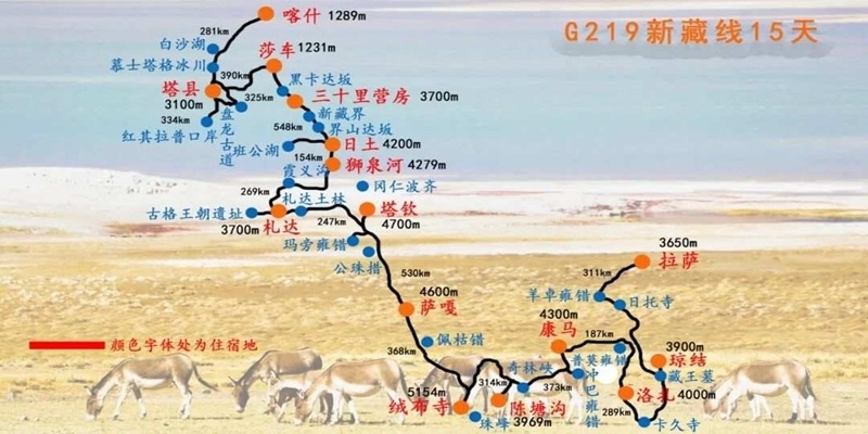
The G219 National Highway is the most iconic and earliest-built route connecting Xinjiang and Tibet, earning its reputation as a legendary “heavenly road” among global travelers. Stretching 2,140 kilometers from the Zero Kilometer Monument in Yecheng County, Kashgar Prefecture of Xinjiang in the north to Chawu Township, Lhatse County, Xigazê City of Tibet in the south, it ranks among the highest-altitude national highways in the world.
The G219 National Highway
Road Conditions and Altitude Profile
This route boasts an average altitude of over 4,500 meters, with travelers needing to cross 16 ice passes and ford 44 glacial rivers along the way. Five of these passes exceed 5,000 meters in elevation. Starting at just 1,480 meters in Yecheng, the highway climbs dramatically to over 5,000 meters within a few hundred kilometers, making it the steepest altitude ascent of any Tibet-bound route. Its highest point, Jieshan Pass, reaches 5,347 meters above sea level. In recent years, the opening of Kunlun Tunnel No.1, No.2 and No.3 has drastically improved safety on the once-notorious Kudi, Mazar and Heiqia passes, significantly cutting travel time. Over 95% of the entire route is now paved, making it passable for regular sedans, though extra caution is advised on high-altitude sections where snow and ice persist in winter.
Departing Yecheng: First Glimpses of Gobi and Snow-Capped Peaks
The greatest allure of traveling the G219 lies in its dense and diverse natural and cultural landscapes. Setting off from Yecheng, you will first traverse the Karakash River Valley, flanked by tawny Gobi deserts and barren mountains with sparse vegetation, exuding a desolate yet majestic atmosphere. As the highway winds upward along the valley, snow-capped peaks in the distance gradually come into sharper focus. After crossing the three major passes, you will enter the heart of the Karakoram Mountains, where towering snow-capped mountains and glaciers dominate the horizon. The pure white snow peaks glow brilliantly against the blue sky, and sunlight reflects off the glaciers in dazzling rays.
Sanshili Yingfang: Key Resupply Hub and High-Altitude Introduction
Sanshili Yingfang is the most important resupply point in the Xinjiang section and a storied military stronghold. Here, you will see numerous military vehicles and soldiers, feeling the sacredness and solemnity of the border region. About 120 kilometers south of Sanshili Yingfang lies Qitai Pass, standing at 5,248 meters—the first pass on the G219 to exceed 5,000 meters. At the summit, the panoramic views are breathtaking, with surrounding snow-capped mountains stretching as far as the eye can see and clouds rolling beneath your feet, making you feel as if you have stepped into a fairyland.
Jieshan Pass: Crossing into Tibet and Encountering Pangong Lake
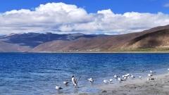
Continuing south through Hongliutan and Quanshui Lake, you will reach Jieshan Pass, the natural boundary between Xinjiang and Tibet. Standing before the Jieshan Pass stone monument, you will feel an indescribable excitement as you finally set foot on Tibetan soil. Entering Ngari Prefecture of Tibet, the first major attraction is the famous Pangong Lake. This long, narrow lake stretches approximately 150 kilometers from east to west, and its most remarkable feature is its split water chemistry: the Chinese side is freshwater, crystal clear and teeming with Tibetan schizothoracin, while the Indian side is saltwater and unfit for drinking. The lake is dotted with more than a dozen small islands, which become home to thousands of brown-headed gulls, bar-headed geese and other migratory birds every summer, creating a spectacular bird island phenomenon with flocks of birds soaring above the water.
Shiquanhe: Rest, Resupply and Wildlife Spotting on the Tibetan Grasslands
South of Pangong Lake, passing through Rutog County, you will arrive at Shiquanhe Town, the capital of Ngari Prefecture. As the largest resupply point on the Xinjiang-Tibet overland journey, Shiquanhe offers comprehensive facilities including supermarkets, restaurants, hotels and hospitals, making it the perfect place to rest for a day, replenish supplies and acclimatize to the high altitude. Continuing south along the G219 from Shiquanhe, you will traverse the vast Northern Tibetan Grasslands, where herds of Tibetan antelopes, Tibetan wild asses and wild yaks roam freely. Sometimes, these curious creatures will pause to watch passing vehicles, offering unforgettable wildlife encounters.
Sacred Mountain and Lake: Mount Kailash and Lake Manasarovar
Further south lies the most sacred part of the entire route: Mount Kailash and Lake Manasarovar. Standing at 6,656 meters, Mount Kailash is the main peak of the Gangdise Mountains, revered as the “King of Sacred Mountains” by Tibetan Buddhism, Hinduism, Jainism and Bon. Every year, countless pilgrims from around the world come to circumambulate the mountain, prostrating themselves step by step to measure this sacred land with their bodies. Lake Manasarovar, located south of Mount Kailash at an altitude of 4,588 meters, is China’s clearest freshwater lake and one of the three sacred lakes of Tibetan Buddhism. Its sapphire-blue waters are surrounded by snow-capped mountains and grasslands, creating stunning scenery. Believers hold that the lake’s waters can wash away sins and troubles, bringing good fortune and happiness.
Final Stretch: Merging with G318 in Lhatse and Scenic Finale
Continuing southeast through Payang Town, Zhongba County and Saga County, you will finally reach Chawu Township in Lhatse County, where the G219 merges with the G318 National Highway. From here, you can take the G318 to Xigazê and Lhasa, passing by Shishapangma Peak and Peiku Lake along the way. Shishapangma Peak, at 8,012 meters, is the only 8,000-meter peak entirely within Chinese territory, perpetually covered in snow and imposing in its grandeur. Peiku Lake, the largest lake in Xigazê Prefecture, boasts deep blue waters that contrast beautifully with the surrounding snow-capped mountains, creating a mesmerizing final scene for your G219 journey.
G216 Second Xinjiang-Tibet Highway: The Miracle Road Through Qiangtang
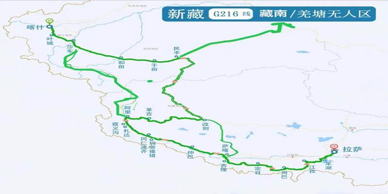
The Minfeng to Gaize section of the G216 National Highway, officially opened in 2023, is the second regular overland route from Xinjiang to Tibet, hailed as the “10th route into Tibet”. Stretching approximately 820 kilometers from Minfeng County in Hotan Prefecture of Xinjiang to Gaize County in Ngari Prefecture of Tibet, it is currently the only legal highway that passes through the core area of the Qiangtang No-Man’s-Land.
The G216 National Highway
Road Conditions and Altitude Challenges
The G216 is a true engineering marvel, starting from the southern edge of the Taklamakan Desert and cutting southward through the Kunlun Mountains and Qiangtang No-Man’s-Land. Its altitude rises sharply from just over 1,300 meters in Minfeng to over 5,000 meters, with its highest point, Geming Pass, reaching 5,424 meters—higher than Jieshan Pass on the G219. Almost the entire route consists of straight, well-paved roads, with conditions far better than many people expect, making it passable for regular SUVs. However, the real challenges of this route lie in its extreme altitude and utter desolation: over 600 kilometers of the road lie above 5,000 meters, and there is almost no human habitation along the way, which can evoke a profound sense of isolation.
Departing Minfeng: From Desert Edge to Qiangtang No-Man’s-Land
Traveling the G216 offers a chance to experience the most primitive and spectacular wilderness beauty on Earth. Setting off from Minfeng, you will first pass through the edge of the Taklamakan Desert, where golden sand dunes glisten in the sun and occasional poplar trees stand resiliently in the desert, showcasing the tenacity of life. After passing the Kuyake Service Area, you will officially enter the Qiangtang No-Man’s-Land. This is one of the least human-inhabited areas on the planet, with no villages, no farmland and no cell phone signal—only endless plateaus, continuous snow-capped mountains and scattered alpine lakes stretching to the horizon.
Inside the No-Man’s-Land: Alpine Lakes and Heishi North Lake
Along the way, you will pass numerous alpine lakes including Meima Lake, Kunchuke Lake, Luotuo Lake and Heishi North Lake. These lakes are like sapphires scattered across the plateau, displaying stunning shades of deep blue, light blue and green, and looking like paradise against the backdrop of snow-capped mountains. Heishi North Lake marks the boundary between Xinjiang and Tibet, and its shores are covered with black volcanic rocks, creating a landscape that resembles the surface of Mars—an awe-inspiring sight that reminds you of nature’s grandeur and humanity’s insignificance, washing away all your worries.
Unique Charm: Up-Close Encounters with Wildlife
The entire section is incredibly rich in wildlife, with Tibetan antelopes, Tibetan wild asses, wild yaks and Tibetan foxes frequently seen running alongside the highway. On occasion, you may witness the spectacular mass migration of Tibetan antelopes, where thousands of these graceful animals form long lines and slowly cross the road—a sight that will stay with you for a lifetime. This is an experience rarely found anywhere else and is the most unique charm of the G216 Second Xinjiang-Tibet Highway.
Route Extensions: Loop Itinerary Recommendations
After reaching Gaize County, the G216 continues southward through Dong Lake, Coqen County and Saga County, eventually reaching Gyirong Port on the China-Nepal border. From Gaize County, you can also turn northwest to Shiquanhe Town, where it merges with the G219 to form a perfect loop. Many experienced travelers choose this loop itinerary, entering Tibet via the G219 and exiting via the G216 (or vice versa), allowing them to experience two distinct heavenly roads without backtracking and gain a richer travel experience.
Two Ancient Expedition Trails: For Extreme Adventurers Only
In addition to the two regular paved highways, there are two ancient historical trails connecting Xinjiang and Tibet: the Keriya Ancient Trail and the Sangzhu Ancient Trail. Neither is paved, and their road conditions are extremely treacherous, making them suitable only for professional off-road expedition teams and not recommended for casual travelers.
Keriya Ancient Trail: The Abandoned Mysterious Ancient Passage
The Keriya Ancient Trail stretches approximately 500 kilometers between Yutian County in Hotan Prefecture of Xinjiang and Gaize County in Ngari Prefecture of Tibet. Once an important trade route connecting Xinjiang and Tibet in ancient times, it was later abandoned. The trail requires crossing the 5,500-meter-plus Liuhuang Pass and Hongtu Pass, traversing the heart of the no-man’s-land with no resupply points or cell phone signal along the way. While the Keriya Ancient Trail offers incredibly primitive and magnificent scenery including volcanoes, hot springs, glaciers and abundant wildlife, it is also extremely dangerous, with only a handful of professional expedition teams successfully crossing it each year.
Sangzhu Ancient Trail: The Hidden Extreme Challenge Route
The Sangzhu Ancient Trail, stretching about 150 kilometers between Sangzhu Township in Pishan County of Xinjiang and Saitula Town in Ngari Prefecture of Tibet, is even more obscure and less known than the Keriya Ancient Trail. It requires crossing the 5,300-meter Sangzhu Pass, with rugged road conditions where many sections are only wide enough for one vehicle to pass, with sheer cliffs on one side and deep abysses on the other. Along the Sangzhu Ancient Trail, you can see ancient post station ruins and stunning snow-capped mountain scenery, but it also carries high risks and is absolutely not recommended for inexperienced travelers.
Route Selection Guide: Pick the Perfect Path for You
Choosing the right route for your Xinjiang to Tibet overland journey depends primarily on your travel preferences, vehicle condition and physical fitness. Here are our specific recommendations:
- Casual travelers / First-time Tibet visitors: Prioritize the G219 Xinjiang-Tibet Highway. This route has been open for the longest time, with relatively complete resupply and communication facilities along the way, and the most diverse landscape types—from majestic snow-capped mountains and glaciers to sacred religious sites. It is suitable for most people. We recommend setting aside 10-15 days to fully enjoy the scenery and acclimatize to the high altitude.
- Experienced self-drivers / Photography enthusiasts: Opt for the G216 Second Xinjiang-Tibet Highway. This route offers more primitive and desolate scenery, allows close access to the Qiangtang No-Man’s-Land, and has very little traffic, making it ideal for photography. Note that your vehicle must have a range of over 600 kilometers, and we recommend traveling in a convoy of at least two vehicles for mutual support.
- Extreme off-road adventurers: May attempt the Keriya Ancient Trail and Sangzhu Ancient Trail. These unpaved trails have treacherous road conditions and require extensive off-road experience, professional equipment and team support. Never enter alone or without proper preparation.
Choosing the Best Overland Route from Xinjiang to Tibet
Traveling overland from Xinjiang to Tibet is more than just a road trip—it is a once-in-a-lifetime expedition across some of the most awe-inspiring landscapes on Earth. From the iconic G219 Xinjiang–Tibet Highway to the newly opened G216 route through the Changtang Plateau, each path offers a unique blend of adventure, culture, and natural wonder. Selecting the right route based on your experience, vehicle, and travel preferences ensures both safety and an unforgettable journey.
For a seamless and well-organized experience, partnering with a professional travel agency is highly recommended. China Dragon Travel specializes in Tibet and Western China expeditions, offering expert route planning, travel permits consultation, and customized overland journeys. With professional support, you can confidently embark on an extraordinary adventure across the Roof of the World.