
Mount Namcha Barwa is one of the most striking peaks in the eastern Himalaya, rising above the forests and river valleys of Nyingchi in the Tibet Autonomous Region. Its dramatic form, often veiled by cloud, makes a clear view feel like a gift rather than a guarantee. A trip here is about more than reaching a viewpoint: it means following the Yarlung Tsangpo through a landscape where snow peaks, deep gorges, and evergreen hills meet. The most useful approach is to allow time for changing weather, choose a viewing area that suits your route, and treat local travel requirements as part of the planning rather than an afterthought. Whether you are visiting from Nyingchi city, exploring the area around the Yarlung Tsangpo Grand Canyon, or adding the mountain to a broader Tibet itinerary, preparation can make the journey calmer and more rewarding.
Key Points
- Mount Namcha Barwa stands in Nyingchi, southeastern Tibet, near the Yarlung Tsangpo Grand Canyon.
- Its summit is commonly reported at about 7,782 meters, though visitors experience it from lower valleys and designated viewpoints.
- Visibility depends on clouds and weather; allow more than one opportunity to see the peak if your schedule permits.
- The area is reached by road, but distances, driving times, and access arrangements vary by starting point and conditions.
- Check current Tibet travel requirements, park access rules, and road conditions before departure.
Why Mount Namcha Barwa Captures the Imagination
Mount Namcha Barwa, also written Namjagbarwa, is among the highest peaks in the eastern Himalaya. Its elevation is commonly given as approximately 7,782 meters. The mountain is located in Nyingchi, close to the great bend of the Yarlung Tsangpo River, where the river cuts through a vast gorge on its journey eastward. This meeting of a high Himalayan massif and a deep, forested river valley gives the area a character quite different from Tibet’s broad plateau landscapes.
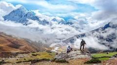
The mountain’s shape is a major part of its appeal. From the right angle, its ridges and pointed summit rise above layers of forest and cloud. Yet the peak is frequently hidden, especially when moisture gathers around the gorge. Visitors should not expect a postcard-clear view at a particular hour. The changing conditions are part of the experience: one moment the slopes may appear in fragments, and later the cloud may lift enough to reveal the upper mountain.
The name is often associated with local religious and cultural traditions, and the peak holds significance beyond its appearance. Nyingchi is home to communities with distinct languages, customs, and relationships to the surrounding mountains and rivers. Travelers can appreciate the landscape while remembering that this is also a lived-in region, not simply a backdrop for photography. Respectful behavior, careful photography, and attention to local guidance matter throughout the journey.
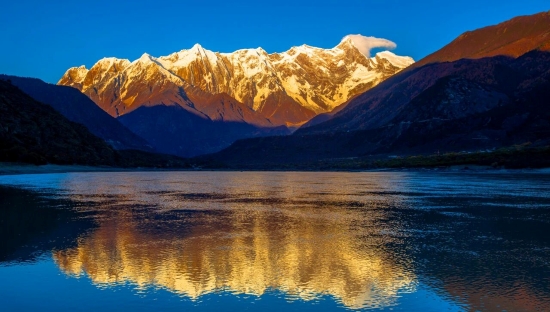
Golden Sunlit Summit of Namcha Barwa
Understanding the Landscape Around the Peak
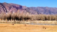
A visit to Mount Namcha Barwa usually involves several landscapes rather than one isolated mountain stop. The Yarlung Tsangpo flows through steep terrain, while surrounding valleys support forests, villages, and agricultural land. The combination of elevation, river moisture, and local topography creates noticeable changes over relatively short distances. A drive may pass through humid-looking vegetation before opening onto a broad view of a glacier-covered summit.
The Yarlung Tsangpo Grand Canyon is closely connected with the mountain’s setting. The river makes a dramatic turn around the Namcha Barwa massif, producing a region known for its exceptionally rugged relief. Exact descriptions of the canyon’s dimensions vary according to how its boundaries are measured, so it is better to focus on what travelers can directly observe: steep slopes, powerful river scenery, and roads that follow the contours of a challenging landscape.
Do not confuse a valley viewpoint with access to the summit. Mount Namcha Barwa is a serious high-altitude mountain, and the scenery most visitors enjoy comes from lower elevations. Technical mountaineering is a separate undertaking requiring appropriate experience, permits, equipment, and specialist support. For an ordinary sightseeing visit, the sensible plan is to stay on established roads and viewing areas rather than seeking an improvised route toward the mountain.
Choosing a Viewpoint
There is no single viewpoint that suits every itinerary. The best choice depends on where you are staying, how much time you have, road conditions, and whether you want a broad landscape panorama or a closer look at the surrounding gorge. Visitors commonly plan around viewpoints and scenic areas in the Yarlung Tsangpo Grand Canyon region, including locations associated with the settlement of Zhibai. Access and the precise visitor experience can change, so confirm the current arrangement locally before setting out.
Viewpoints in the Grand Canyon Area
A viewpoint in the canyon area can bring together the mountain, river, forested slopes, and the scale of the gorge. This is often the most rewarding choice for travelers who want to understand how the peak fits into the wider landscape. Rather than rushing from one photo stop to another, spend time observing how cloud moves across the ridges and how the river corridor shapes the view.
Some scenic areas operate with designated entrances, transport arrangements, or internal routes. These details may change, and not every road or village access point is necessarily open to independent visitors. Ask your hotel, local guide, or the relevant visitor service about access before building a day around a particular stop. If you are traveling with a driver, agree on pickup points and waiting arrangements in advance, especially where mobile coverage is limited.
Viewing from the Nyingchi Area
Nyingchi is a useful base for a wider regional trip, but it is not a guarantee of a close or unobstructed view of Mount Namcha Barwa. The city and the mountain are separated by a substantial journey through changing terrain. Travelers who want a meaningful chance to see the peak should plan a dedicated excursion toward the canyon region rather than treating the mountain as a quick roadside detour.
Depending on your route, you may also encounter distant mountain views while traveling through Nyingchi. These can be attractive, but distance, haze, and cloud can make it difficult to identify the summit clearly. For trip planning, distinguish between a general mountain panorama and a viewpoint specifically chosen for Namcha Barwa.

Namcha Barwa
When to Visit for the Best Chance of a View
The weather in the eastern Himalaya can change quickly, and no season guarantees a clear summit. The period from spring into autumn is often considered practical for regional travel because roads and visitor services are generally easier to use than during harsher winter conditions. However, rain, cloud, and local road interruptions remain possible. Seasonal conditions vary from year to year, so check a reliable local forecast shortly before travel.
Autumn is often favored by travelers seeking clearer air, but it is still possible for the peak to disappear into cloud. Spring can bring fresh vegetation and changing weather, while summer is greener but may include more rain and lower visibility. Winter can offer crisp views on suitable days, yet cold temperatures, icy sections, or travel disruptions may complicate the journey. These are broad patterns, not promises for a specific date.
Time of day also matters, though it is not a simple rule. A morning departure can give you more flexibility if conditions change, but cloud may gather or lift at different times depending on the day. The most useful strategy is to avoid placing your only viewing opportunity at the end of a tightly packed itinerary. If the mountain is a priority, leave room for an extra night or a second attempt when practical.
Keep expectations realistic. A partly obscured mountain can still make a memorable scene, especially when the river and forested slopes are visible. Instead of judging the trip only by whether the summit is fully exposed, pay attention to the wider atmosphere of the gorge and the way light changes across the valley.
How to Get There
Most travelers reach Nyingchi by air or overland travel, then continue by road toward the Yarlung Tsangpo Grand Canyon region. The most suitable route depends on your arrival point, itinerary, road conditions, and the access rules in force for your visit. Driving times can vary considerably with traffic, weather, roadwork, stops, and the precise destination, so avoid relying on a single estimate when arranging flights or hotel check-ins.
A private vehicle with a driver or a guided tour can simplify travel between Nyingchi and remote viewing areas. This is especially useful if you do not speak the local languages, are unfamiliar with mountain roads, or need help coordinating entry arrangements. Independent travelers should confirm whether their planned route is open to them and whether advance reservations or local transport are required. Do not assume that a road visible on a map is freely accessible or suitable for a standard rental car.
Travel from Nyingchi City
Nyingchi can work well as a staging point for exploring nearby attractions, but the canyon and mountain viewpoints require advance planning. Discuss the route, expected stops, and return time with your driver before departure. Carry water, snacks, warm layers, and any medication you may need; services can be sparse once you are away from larger settlements.
If your broader trip includes other parts of Tibet, consider the order of travel carefully. Tibet travel rules and permit arrangements can depend on nationality, route, and the structure of the itinerary. Requirements may change, and visitors should verify them through the appropriate official channels or a licensed travel provider before booking nonrefundable transport.
Road and Access Considerations
Mountain roads may include bends, narrow sections, changing surfaces, and long stretches with limited services. Rain or other weather can affect conditions, and schedules are not always predictable. Keep a flexible plan, follow the driver’s safety advice, and avoid pressuring anyone to drive faster to make a viewpoint or reservation.
Some scenic areas use shuttle buses or designated visitor routes. Ask whether tickets, transport, or a local guide are needed before arrival. If you are visiting a village or a viewpoint outside a formal scenic area, check that access is permitted and do not block local roads or entrances while taking photographs.
Practical Preparation for the Journey
Altitude and Health
Nyingchi and the surrounding region are at high elevation, although altitude varies greatly between the city, valleys, and mountain terrain. People respond differently to altitude, and even travelers who feel well initially should avoid pushing themselves too hard. Spend time adjusting to the elevation, drink fluids regularly, limit strenuous activity at first, and seek medical advice before travel if you have a health condition that may be affected.
Headache, unusual fatigue, nausea, dizziness, or shortness of breath can be signs of altitude-related illness. Symptoms should not be dismissed as ordinary travel tiredness, especially if they worsen. Tell your travel companion or guide, stop exertion, and seek medical assistance. Severe symptoms require urgent help. A travel plan should include a way to contact local support rather than assuming that help will be immediately available at a remote viewpoint.
Clothing and Daypack
Conditions can feel very different between a sunny roadside stop and a shaded, windy viewpoint. Pack layers that can be added or removed: a warm mid-layer, a wind- and rain-resistant outer layer, comfortable trousers, and sturdy shoes with good grip. A hat, sunglasses, and sunscreen are useful even when the air feels cool. Bring a small daypack for water, snacks, medication, identification, and a portable charger.
Photography gear is best kept practical. A camera with a zoom lens can help frame distant ridgelines, but weather protection matters more than carrying several heavy lenses. Keep batteries warm in cold conditions and avoid changing lenses in dusty or wet places. A smartphone may be sufficient for landscape photographs, particularly when visibility is limited and the wider scenery is the subject.
Money, Connectivity, and Essentials
Do not rely on every remote shop accepting your preferred payment method. Carry some local currency for small purchases, while keeping cash secure. Mobile coverage and data service may be inconsistent in mountain areas. Download maps and important travel details before leaving a town with reliable connectivity, and tell someone your expected route and return time.
Bring personal medicines and basic supplies, as the selection available outside larger settlements may be limited. Keep passports, permits, and other required documents accessible but protected. Requirements differ by traveler and itinerary; confirm exactly what documents apply to you before travel rather than relying on informal advice found online.
Respectful Travel in Nyingchi
The landscape around Mount Namcha Barwa is home to communities whose traditions and daily routines deserve consideration. Dress and behave respectfully at religious or culturally significant places, follow posted rules, and ask before photographing people. A friendly gesture does not replace consent, particularly for portraits or photographs taken near homes, ceremonies, or places of worship.
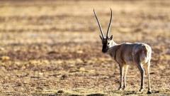
Stay on marked paths and keep a safe distance from river edges, steep slopes, and roadside drop-offs. Do not climb barriers for a better angle. Avoid picking plants, disturbing wildlife, or leaving food and rubbish behind. In remote places, even small amounts of litter can be difficult to remove and may affect animals or local water sources.
If you visit a village, treat it as a community rather than an attraction. Do not enter private property without an invitation, and avoid photographing children without permission from a parent or guardian. Purchase local products only when you genuinely want them, and ask before making assumptions about customs or meanings attached to objects and rituals.

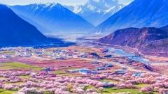
Distant View of Peach Blossoms and Snow Mountains in Nyingchi
Food and Places to Stay
Nyingchi offers the broadest choice of accommodation and dining in the area, while lodging becomes more limited as you move toward smaller settlements and scenic zones. A stay closer to your planned viewpoint can make an early departure easier, but facilities may be simpler and availability can be seasonal. Confirm the location, heating, meal options, and transport arrangements before booking, especially if your visit falls during a busy travel period.
Food options in the region can include Tibetan, Sichuan-style, and other Chinese dishes, with menus varying between towns and villages. Travelers with dietary restrictions should explain their needs clearly and carry a suitable snack for long drives. Restaurant availability may be limited outside larger centers, so ask your driver or accommodation host whether meals need to be arranged ahead of time.
A meal is also a chance to experience local flavors without assuming that every dish is available everywhere. Try regional food when it suits your preferences, and ask about ingredients if you have allergies or follow a restricted diet. In remote areas, simple planning is more useful than expecting a particular restaurant or specialty to be open.
Building Mount Namcha Barwa into a Tibet Itinerary
A visit works best when it is not squeezed between long drives. Consider allowing at least one overnight near the region you want to explore, with an additional flexible day if seeing the peak is a central goal. The exact duration depends on your starting point, road access, and other destinations in Nyingchi. A slower schedule gives you more time to respond to weather and makes the journey less tiring.
If you are combining the mountain with other attractions in Nyingchi, group destinations according to geography rather than trying to cover the whole region in a single day. Roads through the area can make apparently short distances take longer than expected. Confirm the order of stops with a local driver or guide who understands current road and visitor conditions.
China Dragon Travel can be considered when arranging a guided Tibet itinerary or seeking help with transport and route planning. Before booking with any provider, confirm what is included, which permits or tickets are handled, the accommodation standard, cancellation terms, and whether the itinerary allows enough flexibility for weather. Ask specific questions in writing so that expectations about driving time, access, and included services are clear.
The most dependable itinerary is one that leaves space for the unknown. Keep an extra layer in the vehicle, avoid scheduling an important connection immediately after a remote excursion, and treat a clear view as a possibility rather than a guaranteed outcome. That approach makes the experience worthwhile whether the summit appears in full or remains partly hidden.
Frequently Asked Questions
Where is Mount Namcha Barwa?
Mount Namcha Barwa is in Nyingchi, in the southeastern part of the Tibet Autonomous Region. It lies near the great bend of the Yarlung Tsangpo River and the Yarlung Tsangpo Grand Canyon region.
How high is Mount Namcha Barwa?
Its elevation is commonly reported at approximately 7,782 meters. Travelers generally view the peak from lower valleys and established viewpoints; reaching the summit is a technical mountaineering undertaking, not a sightseeing activity.
When is the best time to see Mount Namcha Barwa?
Spring through autumn is often practical for regional travel, while autumn is frequently preferred for the possibility of clearer air. Cloud and local weather can obscure the mountain in any season, so no date guarantees a clear view.
Do I need a guide to visit the area?
A guide is not a universal requirement for every viewpoint, but access rules, permits, and transport arrangements depend on your route and circumstances. Verify current requirements before departure. A local driver or guide can be helpful on remote roads and when coordinating scenic-area access.