
The lowest altitude place in Tibet is generally identified as the Yarlung Tsangpo Grand Canyon in Nyingchi, where the river descends to roughly 600 metres above sea level in its deepest section. That figure is often cited as a geographic reference, not as the elevation of a single roadside viewpoint or an easy-to-reach tourist stop. The canyon stretches through a remote, rugged part of southeastern Tibet, and its terrain changes sharply from high mountain slopes to a deep river valley. For travelers, the practical answer is that the lowest point lies in the lower reaches of the Yarlung Tsangpo, near the Great Bend and the canyon’s deepest gorge, rather than in Lhasa or the better-known plateau towns. This guide explains what the elevation means, where the canyon is, how visitors can approach the area, and how to plan responsibly for a journey into one of Tibet’s most dramatic landscapes.
Key Points
- The lowest altitude in Tibet is commonly associated with the deepest section of the Yarlung Tsangpo Grand Canyon, at approximately 600 metres above sea level.
- The canyon is in Nyingchi, in southeastern Tibet, where the Yarlung Tsangpo makes its famous Great Bend around Namcha Barwa.
- The quoted elevation describes a deep river-gorge area; it does not mean visitors can reach the exact lowest point by car or on a standard sightseeing route.
- Nyingchi is much lower than central Tibet, but it remains a high-altitude destination, and acclimatization and local travel requirements still matter.
- A visit is best planned around accessible canyon viewpoints and local guidance, with extra time for weather, road conditions, and permits.
Where Is the Lowest Altitude Place in Tibet?
The lowest altitude place in Tibet is found in the Yarlung Tsangpo Grand Canyon, in Nyingchi Prefecture in the southeastern part of the Tibet Autonomous Region. The river cuts through a mountain landscape near Namcha Barwa, one of the region’s most prominent peaks, before turning sharply at the Great Bend and continuing toward India, where it is known as the Brahmaputra.
The deepest part of the gorge is commonly described as being around 600 metres above sea level. This makes it exceptionally low compared with much of Tibet, where towns, roads, and settlements often sit several thousand metres above sea level. The contrast is striking: within one broad region, the landscape can shift from high, open plateau country to a humid, steep-sided river valley.
It is useful to distinguish the canyon’s lowest elevation from the lowest place an ordinary visitor can reach. The river’s deepest sections lie in difficult terrain, and access varies by location, season, road conditions, and local regulations. A viewpoint or village in the canyon area may sit considerably higher than the river itself. Travelers should therefore treat the approximately 600-metre figure as a geographic description of the gorge, not a guaranteed destination or a precise point on a public tourist map.

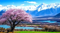
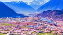
Spring Scenery of the Yarlung Zangbo River
Understanding the Yarlung Tsangpo Grand Canyon
The Yarlung Tsangpo Grand Canyon is a vast river gorge formed where the Yarlung Tsangpo passes through the eastern Himalaya. Its best-known feature is the Great Bend, where the river curves around the massif of Namcha Barwa before flowing south through a deep, narrow valley. The canyon is celebrated for its scale, steep relief, and changing environments, but its geography is complex: elevations differ greatly between the river, the valley floor, nearby settlements, and the surrounding peaks.
The river’s course helps explain why this part of Tibet reaches such a low elevation. Much of the Tibetan Plateau is elevated, but the Yarlung Tsangpo has carved a route through the mountains and descends dramatically as it approaches the eastern Himalayan region. The result is a deep gorge with a very different climate and landscape from the dry, exposed plateau farther west.
Nyingchi is often described as one of Tibet’s greener regions. Forested slopes, river valleys, and comparatively mild conditions distinguish it from the high-altitude scenery around Lhasa and the central plateau. However, “mild” is relative. The area remains mountainous, weather can change quickly, and roads may be affected by rain, landslides, or other local conditions. The canyon is not a simple lowland destination; it is a remote mountain environment with significant differences in elevation over short distances.
Why the Elevation Figures Can Differ
Different sources may give slightly different numbers for the canyon’s depth or the elevation of its lowest section. This is not necessarily a contradiction. The gorge covers a large area, and measurements may refer to different river bends, valley sections, or points along the river. Some figures describe the depth of the canyon relative to nearby peaks, while others refer to the river’s elevation above sea level.
For a travel question, the clearest wording is that the lowest altitude in Tibet is generally cited in the deepest reaches of the Yarlung Tsangpo Grand Canyon, at roughly 600 metres above sea level. Avoid assuming that every visitor site in the canyon reaches that elevation. If a tour description lists a specific altitude, check whether it refers to the river, a village, a viewpoint, or the surrounding terrain.
How the Canyon Compares With Other Places in Tibet
The canyon’s low elevation stands out because many familiar Tibetan destinations are much higher. Lhasa is around 3,650 metres above sea level, while Shigatse is also well above 3,000 metres. Even Nyingchi’s main urban area is considerably higher than the river’s lowest gorge sections. The exact elevation varies by neighborhood and measurement point, so it is better to compare broad ranges than to treat every town as having one fixed altitude.
This difference matters for both geography and travel planning. Visitors who begin in Lhasa may experience a substantial change in elevation when traveling to Nyingchi, but they should not assume that a lower destination eliminates altitude-related concerns. The journey may include high passes, elevated towns, and long drives before reaching lower parts of the river valley. A route can rise and fall repeatedly, and the elevation at an overnight stop may be very different from that of a daytime viewpoint.
The canyon also differs from the open plateau in its vegetation and atmosphere. The lower valley is shaped by river moisture, steep slopes, and a warmer regional climate. Forests and dense greenery are more visible in parts of Nyingchi than in the drier landscapes around central Tibet. These changes make the journey feel like a transition between distinct ecological zones rather than a straightforward descent from one altitude to another.
Can Travelers Visit the Lowest Point?
Most travelers should not expect to stand at the exact lowest point of Tibet. The deepest gorge is remote and physically challenging, and some sections are not accessible through ordinary tourism infrastructure. Access may be restricted or require arrangements through local authorities and operators. Even where a road or viewpoint provides access to the canyon region, it may not reach the river’s lowest elevation.
A more realistic plan is to visit accessible areas in the Yarlung Tsangpo Grand Canyon region and enjoy the landscape from approved viewpoints, villages, or established routes. The best choice depends on current access conditions and the kind of trip you want: a scenic drive, a cultural visit, a photography-focused itinerary, or a longer journey through Nyingchi. Confirm the route and permitted stops before departure rather than relying on an old map or an unverified online claim.
For visitors, the experience is not defined only by reaching a number on an altimeter. The canyon’s scale becomes clear through the relationship between the river, forested slopes, and surrounding mountains. A viewpoint that sits well above the river can still offer a powerful sense of the terrain. In many cases, a responsible, well-planned visit to an accessible location is more rewarding than trying to pursue a remote point without the right permissions or local support.
Planning a Trip to Nyingchi and the Canyon
Choose a Practical Starting Point
Nyingchi is the most practical regional base for exploring southeastern Tibet. Travelers commonly plan a route that includes the city area and selected sights in the surrounding region, then add canyon destinations according to road access and available time. The exact itinerary depends on where you arrive, the length of your stay, and whether you are traveling independently or with an organized tour.
Do not plan the trip around a single elevation figure. Instead, identify the places you can legally and realistically visit, then check the driving distances, overnight stops, and road conditions. In mountainous terrain, a short distance on a map can take much longer than expected. Weather, construction, traffic controls, and local access rules can all affect the day’s schedule.
Allow Time for the Journey
Travel in Tibet often involves long road journeys, and Nyingchi is no exception. A route from Lhasa may pass through changing landscapes and several different elevations. Build flexibility into the itinerary rather than scheduling a tight sequence of stops. This is especially important if you hope to reach remote canyon viewpoints, where a delay can affect the entire day.
A slower pace also gives travelers more time to adjust to altitude and to enjoy the scenery. Even if the canyon floor is relatively low, the route to it may include high-altitude sections. Avoid strenuous activity immediately after arrival, drink water regularly, and pay attention to how you feel. Anyone with a medical condition or concerns about altitude should seek professional medical advice before traveling.
Check Entry and Travel Requirements
Travel rules for Tibet can depend on nationality, travel status, and the route being taken. Foreign visitors generally need to arrange the required permits and travel through an authorized agency; requirements and procedures can change. Confirm the latest rules with a qualified travel provider before booking transport or accommodation. Do not assume that a permit for one area automatically covers every destination in Nyingchi or the canyon region.
Carry identification and any required travel documents, and follow instructions at checkpoints. Some areas may have restrictions on photography or access. Local rules take precedence over a tour plan, and a responsible operator should explain what is permitted before the trip begins.

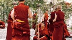
Travelers with China Dragon Travel
What to Pack and How to Stay Comfortable?
Pack for changing conditions rather than for the canyon’s lowest elevation alone. A light rain layer, warm clothing, sun protection, comfortable walking shoes, and any personal medication are useful for a Nyingchi itinerary. The valley may feel warmer than the plateau, but temperatures can drop in the evening or at higher stops. Sun exposure can also be strong at altitude, even on cool or cloudy days.
Bring enough water and snacks for long drives, especially if your route includes remote stretches with limited services. Keep essential documents and valuables secure, and carry a power bank if you rely on your phone for navigation or photography. Mobile coverage may be unreliable in some areas, so save key travel information offline and make sure your driver or guide knows the day’s plan.
Respect local communities and the natural environment. Stay on permitted paths, avoid leaving litter, and do not approach the river or unstable slopes for a closer photograph. The gorge’s steep terrain can be hazardous, and wet ground may become slippery. A safe viewpoint is preferable to an unplanned detour toward the water.
A Note on Responsible and Guided Travel
The Yarlung Tsangpo Grand Canyon is a sensitive and remote landscape, so a guided visit can make logistics easier and help travelers understand local conditions. A knowledgeable operator can advise on permitted routes, realistic driving times, suitable stops, and changes in access. This is especially helpful for visitors unfamiliar with Tibet’s travel requirements or the region’s road network.
China Dragon Travel can be considered when comparing organized Tibet itineraries, particularly if you want help coordinating permits, transport, and a route through Nyingchi. Before booking with any provider, ask which canyon locations are included, how much time is spent on the road, what is covered in the price, and whether the itinerary can change due to weather or access restrictions. Confirm all arrangements in writing and make sure the proposed route matches your interests and physical comfort.
A good itinerary should not promise access to the exact lowest point unless that access has been verified and is legally available. It should explain what visitors can actually see, where they will stop, and how the operator handles route changes. Clear expectations make for a safer and more satisfying trip.
Common Questions About Tibet’s Lowest Altitude
Is the Lowest Point in Tibet in Lhasa?
No. Lhasa is a high-altitude city at roughly 3,650 metres above sea level. Tibet’s lowest commonly cited area is in the Yarlung Tsangpo Grand Canyon in southeastern Tibet, where the river reaches much lower elevations.
Is the Lowest Point Exactly 600 Metres Above Sea Level?
Around 600 metres is a commonly cited approximate elevation for the deepest section of the canyon. The precise figure depends on the location and measurement being described. It should not be treated as the guaranteed altitude of a visitor viewpoint or a specific accessible stop.
Is Nyingchi Low Enough to Avoid Altitude Concerns?
No. Nyingchi is lower than many parts of Tibet, but much of the region is still at substantial elevation, and journeys may pass through higher terrain. Travelers should take altitude seriously, pace themselves, and seek medical advice if they have health concerns.
Can I Reach the River’s Lowest Section by Car?
Not necessarily. The deepest gorge is remote, and access varies. Standard tourist routes may reach viewpoints or settlements above the river rather than the lowest point itself. Confirm current access with a qualified local operator before making plans.
What Is the Most Useful Way to Visit?
Plan a flexible Nyingchi itinerary around accessible, permitted viewpoints and local guidance. Allow enough time for road travel, check conditions before departure, and focus on the canyon landscape rather than treating the lowest elevation as a point that every visitor can reach.